Toronto · North York

North York

Condo towers on Yonge Street, quiet streets of postwar houses, the estates of the Bridle Path, and the Don Valley running through it all.

Map of North York in Toronto: the City’s neighbourhoods in this part of the city are shaded, with the subway and LRT lines, main roads, parks, and ravines. Each neighbourhood in this guide is marked; choose one to jump to it.Aga Khan Park & MuseumAlbionAvenueBayviewBroadviewCaledoniaCedarvaleCoxwellDavisvilleDon MillsDownsview ParkDriftwoodDuncanwoodsFinchFinch WestGlencairnHighway 407LairdLawrenceLawrence WestLeslieMount PleasantPioneer VillageRosedaleSheppard-YongeSt. ClairSummerhillSunnybrook ParkVaughan Metropolitan CentreWilsonYorkdaleNorth York CentreBayview VillageBridle PathHoggs HollowDon MillsArmour HeightsLawrence Manor, Clanton Park,DownsviewYork University HeightsNewtonbrookParkwoods
Point to a neighbourhood or tap it; tap again to open itCity of Toronto Open Data and OpenStreetMap
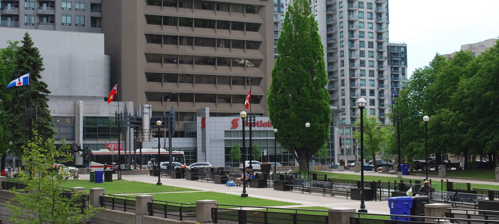
Mel Lastman Square, with office and condo towers on Yonge Street behind it
Mel Lastman Square, North York Centre.
Photo: Enoch Leung from Canada, CC BY-SA 2.0

About North York

North York is the northern part of the city, from the Humber River east to Victoria Park Avenue and up to Steeles Avenue. It became a township in 1922, out of the northern part of the old Township of York, and grew into a city of its own before it joined the new City of Toronto in 1998. Most of it was farmland until the 1950s, when the postwar boom filled it with bungalows, split levels, and the planned town of Don Mills.

Yonge Street is its main street. Line 1 runs up the middle to Finch, with a branch on the west side to York University and Vaughan, Line 4 runs east along Sheppard Avenue, and Line 6 Finch West opened along Finch Avenue West in December 2025. The two branches of the Don River cut through it, so many streets back onto ravine parks.

Schools. Public schools are run by the Toronto District School Board and Catholic schools by the Toronto Catholic District School Board, with French language schools from Conseil scolaire Viamonde and MonAvenir. Catchments follow the address, so it is worth checking one with the board before you buy.

Yonge Street, the 401 north to Steeles Avenue

North York Centre and Willowdale

Willowdale grew from three postal villages along Yonge Street, Newtonbrook, Willowdale, and Lansing. David Gibson, a surveyor who fled after the Rebellion of 1837 and came back in 1848, pushed for the Willow Dale post office. The Georgian house he built in 1851, Gibson House, still stands on Yonge Street as a City museum.

Today North York Centre, around Yonge Street between Sheppard and Finch, is a second downtown, with office and condo towers, the North York Civic Centre, Mel Lastman Square, the North York Central Library, and the Meridian Arts Centre. The side streets behind it are lined with houses.

Homes

Condo towers line Yonge Street, and the side streets east and west have houses from the 1910s to the 1950s, many of them rebuilt in recent years as large new detached houses.

Streets and landmarks

Mel Lastman Square, which hosts events and a winter rink, the Meridian Arts Centre, Gibson House, and York Cemetery, where Tim Horton is buried.

Parks and green space

Earl Bales Park, with a small ski hill, and the West Don ravine, along with Willowdale Park and the many small local parks.

Getting around

Sheppard-Yonge, North York Centre, and Finch stations on Line 1, with Line 4 east from Sheppard-Yonge, and the 401 close by.

Day to day

Yonge Street’s towers, shops, and restaurants, Mel Lastman Square, and the subway at North York Centre and Sheppard-Yonge sit beside quiet streets of houses on either side.

On the City’s neighbourhood map: Yonge-Doris, East Willowdale, Willowdale West, Lansing-Westgate, Avondale, Newtonbrook East, Newtonbrook West. A smaller local name here is North York City Centre.

Bayview Avenue to Leslie Street, the 401 to Finch Avenue East

Bayview Village

Bayview Village was planned in 1954 by a group of developers and sold as contemporary living in the countryside. Its curving streets run down to the East Don ravine, and the Bayview Village Association, a residents’ group, was founded in 1956. Bayview Village Shopping Centre, at the northeast corner of Bayview Avenue and Sheppard Avenue, opened in 1963.

Homes

Detached ranch bungalows and split levels on large lots, many of them replaced by large new houses, with condo towers along Sheppard Avenue near the subway.

Parks and green space

The East Don Parkland and its trails, Bayview Village Park, and Old Cummer GO station at the north edge.

Getting around

Bayview, Bessarion, and Leslie stations on Line 4, Oriole and Old Cummer stations on the Richmond Hill GO line, and the 401.

Day to day

Curving streets run down to the East Don ravine, the shopping centre is at Bayview and Sheppard, and Line 4 is close.

On the City’s neighbourhood map: Bayview Village.

Bayview Avenue east to Wilket Creek

The Bridle Path and Sunnybrook

The Bridle Path is the city’s best known enclave of estates, with houses on lots of two to four acres. It was little more than farmland until 1929, when the Bayview Bridge was built across the West Don valley. Few roads pass through it, and it is wrapped by ravines and parks.

To the north, E. P. Taylor, who also planned Don Mills, bought the Windfields estate in 1937. His house is now the Canadian Film Centre, and the land behind it is Windfields Park. Sunnybrook Health Sciences Centre, which opened as a military hospital in 1948, lies to the south.

Homes

Large detached estates, including modern houses from the 1950s and 1960s and very large newer houses, along with some houses on more usual lots in St. Andrew-Windfields.

Parks and green space

Edwards Gardens and the Toronto Botanical Garden, Sunnybrook Park, Wilket Creek Park, and Windfields Park, all linked by trails along the Don.

Getting around

Mostly by car, with buses along Bayview Avenue and Lawrence Avenue East and York Mills station on Line 1 to the west.

Schools

Several private schools are close by.

Day to day

Large estate lots, quiet roads, and the Don Valley trails, Edwards Gardens, and Sunnybrook Park close by.

On the City’s neighbourhood map: Bridle Path-Sunnybrook-York Mills, St. Andrew-Windfields.

Yonge Street and York Mills Road, in the West Don valley

Hoggs Hollow and York Mills

Hoggs Hollow is named for James Hogg, a Scottish settler who came in 1824 and ran a whisky distillery and a grist mill where Yonge Street crosses the West Don. His sons subdivided the estate in 1856, but the land was boggy and only a few houses were built until the 1920s, when the winding roads and English country style houses that define it today were laid out.

York Mills is the larger area around Yonge Street and York Mills Road, where office towers stand at the intersection and the houses spread out into the ravines. The City’s Don Valley golf course is here too, on Yonge Street near the 401.

Homes

Detached houses on large, often sloping lots, from 1920s country style houses in the hollow to large newer houses, and condos near the subway.

Parks and green space

The West Don ravine, York Mills Valley Park, and the trails that run south toward Sunnybrook.

Getting around

York Mills station on Line 1, with a bus terminal, and the 401 right at the top of the hill.

Day to day

Hoggs Hollow and the York Mills valley are leafy and quiet, with the subway at York Mills and the 401 close.

On the City’s neighbourhood map: Bridle Path-Sunnybrook-York Mills, St. Andrew-Windfields, Lansing-Westgate.

Don Mills Road and Lawrence Avenue East

Don Mills

Don Mills was designed between 1952 and 1965 as a self supporting new town, the idea of industrialist E. P. Taylor. It was built in four neighbourhood quadrants around a central shopping centre, each with its own school, church, and park, and its plan was copied by suburbs across Canada.

The original Don Mills Centre was rebuilt as the Shops at Don Mills, which opened in 2009. On Wynford Drive, the Aga Khan Museum and the Ismaili Centre opened in 2014, with a public park between them.

Homes

Modernist bungalows, split levels, and link houses from the 1950s and 1960s on curving streets, with townhouses, apartment towers, and newer condos near the shopping centre.

Parks and green space

Wilket Creek Park, the Charles Sauriol Conservation Area along the East Don, and the Don Mills Trail.

Getting around

Line 5 Eglinton has stops at Aga Khan Park & Museum, Wynford, and Don Valley, the Don Valley Parkway is close, and buses run north to Line 4.

Day to day

The Shops at Don Mills is the centre, the streets are curving and mid century, and the Don valley trails are close.

On the City’s neighbourhood map: Banbury-Don Mills, Parkwoods-O’Connor Hills, Victoria Village.

Wilson Avenue, Bathurst Street east to the West Don

Armour Heights

Armour Heights is named for John Armour, a farmer who bought land west of Yonge Street from James Hogg in 1838. It runs from Wilson Avenue north across the 401, between Bathurst Street and the West Don. The City groups it with Lansing in its Lansing-Westgate neighbourhood.

Homes

Detached houses on generous lots, many from the 1930s to the 1950s and many rebuilt, with some condos near Yonge Street.

Parks and green space

Earl Bales Park and the West Don ravine.

Getting around

York Mills and Sheppard-Yonge stations on Line 1 to the east, and the 401 close by.

Day to day

Streets of detached houses near Avenue Road, Yonge Street’s shops close by, and the 401 just to the north.

On the City’s neighbourhood map: Lansing-Westgate.

Along Bathurst Street, Lawrence Avenue to Finch Avenue

Lawrence Manor, Clanton Park, and Bathurst Manor

Along Bathurst Street north of Lawrence Avenue is a string of postwar neighbourhoods. Lawrence Manor, between Bathurst Street and the Allen, has shops along Bathurst and Lawrence Plaza, which opened in 1953. Bathurst Manor, built between 1954 and the early 1960s on a plateau above the West Don, is one of several neighbourhoods on Bathurst Street with a large Jewish community and several synagogues.

Homes

Detached bungalows and side splits from the 1950s, many rebuilt as large new houses, with low rise apartments and some condos along Bathurst Street.

Parks and green space

G. Ross Lord Park and the West Don trails, Earl Bales Park, and Baycrest Park.

Getting around

Lawrence West, Yorkdale, Wilson, and Sheppard West stations on Line 1 on the Allen, and buses along Bathurst Street. Glencairn station is at the south end.

Day to day

Bathurst Street’s synagogues, schools, bakeries, and community centres are part of daily life, with Earl Bales Park nearby.

On the City’s neighbourhood map: Englemount-Lawrence, Clanton Park, Bathurst Manor. A smaller local name here is Wilson Heights.

Keele Street and Wilson Avenue

Downsview

Downsview takes its name from the Downs View farm, set up around 1842 near Keele Street and Wilson Avenue. In 1929 de Havilland built an aircraft plant here, and the land later became Canadian Forces Base Downsview. Since the base closed, much of it has become Downsview Park, and the rest is being planned for new housing.

West of Downsview Park, several postwar residential areas, including Maple Leaf, Rustic, Brookhaven-Amesbury, and Pelmo Park-Humberlea, run west toward the Humber River.

Homes

Postwar bungalows and semis from the late 1940s into the 1960s, with newer houses and condos near Sheppard West station and the park.

Parks and green space

Downsview Park, with its lake and trails, and Downsview Dells Park along the Black Creek.

Getting around

Sheppard West and Downsview Park stations on Line 1, with Barrie GO at Downsview Park, and the 401 to the south. Wilson Avenue has the Wilson Village BIA.

Day to day

Downsview Park’s lake, trails, and orchard are close, Line 1 is at Sheppard West and Downsview Park, and Wilson Avenue has its village shops.

On the City’s neighbourhood map: Downsview, Oakdale-Beverley Heights, Yorkdale-Glen Park, Maple Leaf, Rustic, Brookhaven-Amesbury, Pelmo Park-Humberlea. A smaller local name here is Lawrence Heights.

Steeles Avenue, Keele Street to Jane Street

York University Heights and the Jane and Finch area

York University Heights, also called Northwood Park, is named for the main campus of York University on Keele Street. The neighbourhood has a mix of bungalows, semis, and townhouses, and The Village at York University was one of the last large new home developments in the city.

West of it, the Jane and Finch area grew quickly in the 1960s and 1970s with apartment towers and townhouse complexes, and it is one of the city’s most diverse communities. Black Creek Pioneer Village, a living history museum, is beside the university.

Homes

Detached and semi detached bungalows, townhouses, apartment towers, and newer houses at The Village at York University.

Parks and green space

The Black Creek Parkland, Northwood Park, and Downsview Park to the south.

Getting around

Line 1 has York University, Pioneer Village, and Finch West stations, and Line 6 Finch West, which opened in December 2025, runs along Finch Avenue West from Finch West station to Humber College.

Day to day

York University is the centre of the area, with Line 1 stations on campus, and the Black Creek Parkland and Black Creek Pioneer Village are nearby.

On the City’s neighbourhood map: York University Heights, Glenfield-Jane Heights, Black Creek, Humber Summit, Humbermede. A smaller local name here is Emery.

Yonge Street and Finch Avenue, north to Steeles

Newtonbrook and the Steeles corridor

Newtonbrook sits around Yonge Street and Finch Avenue, between the east and west branches of the Don. Settled in the early 1800s, it had saw and grist mills, and in the 1950s it was subdivided for a large residential development. The old Newtonbrook Schoolhouse and the general store were among the few early buildings kept.

Homes

Detached and semi detached houses from the 1950s, many replaced by larger new houses, with condo towers along Yonge Street and Finch Avenue.

Parks and green space

Newtonbrook Park, the East Don Parkland, and G. Ross Lord Park to the west.

Getting around

Finch station, the northern end of the Yonge branch of Line 1, with a large bus terminal, and Old Cummer GO on the Richmond Hill line.

Day to day

Line 1 ends at Finch, Yonge Street has shops and restaurants of many cuisines, and York Region is just across Steeles Avenue.

On the City’s neighbourhood map: Newtonbrook East, Newtonbrook West, Bayview Woods-Steeles, Hillcrest Village, Westminster-Branson.

The Don Valley Parkway east to Victoria Park Avenue

Parkwoods and Victoria Village

Parkwoods, sometimes called Parkwoods-Donalda, runs from the Don Valley Parkway to Victoria Park Avenue, between Lawrence Avenue East and the 401. Its northwest corner, Graydon, is built on hillsides beside the Donalda golf club. To the south, Victoria Village sits around Victoria Park Avenue and Eglinton Avenue East, and to the north, Henry Farm and Don Valley Village surround Fairview Mall.

Flemingdon Park, a planned community of apartment towers and townhouses from the 1960s beside the Don, is officially in North York. We cover it with Thorncliffe Park on our York and East York page.

Homes

Detached bungalows and split levels from the 1950s and 1960s, townhouse complexes, and apartment and condo towers, especially around Fairview Mall.

Parks and green space

The East Don Parkland, the Charles Sauriol Conservation Area, Brookbanks Park, and Three Valleys Park.

Getting around

Don Mills and Leslie stations on Line 4, Line 5 Eglinton stops at O’Connor and Sloane, and the Don Valley Parkway and the 401.

Day to day

Postwar streets, the East Don Parkland and Charles Sauriol Conservation Area for walks, and Fairview Mall and the highways close by.

On the City’s neighbourhood map: Parkwoods-O’Connor Hills, Fenside-Parkwoods, Victoria Village, Don Valley Village, Henry Farm, Pleasant View, Flemingdon Park. Smaller local names here include Parkway Forest, the Peanut, and Graydon Hall.

Sources

We wrote this guide from the public sources listed here, and checked each fact against at least two of them. Neighbourhood names follow local usage, and the City of Toronto’s 158 official neighbourhoods are listed under each entry. The streets named are examples rather than boundaries. Details such as school catchments, zoning, and transit routes change, so please check anything important with the City, the TTC, or the school board.