Toronto · Downtown west

Queen West to Little Italy

Victorian row houses, busy main streets, and Trinity Bellwoods and Dufferin Grove parks, between Spadina Avenue and Lansdowne Avenue.

Map of Queen West to Little Italy in Toronto: the City’s neighbourhoods in this part of the city are shaded, with the subway and LRT lines, main roads, parks, and ravines. Each neighbourhood in this guide is marked; choose one to jump to it.BathurstBayChristieDufferinMuseumOsgoodeOssingtonQueen's ParkSpadinaSt. GeorgeSt. PatrickQueen WestKensington MarketTrinity BellwoodsOssingtonLittle ItalyHarbord VillageLittle PortugalDufferin Grove
Point to a neighbourhood or tap it; tap again to open itCity of Toronto Open Data and OpenStreetMap
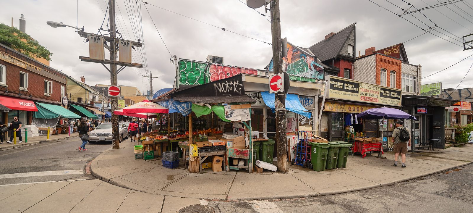
Fruit and vegetable stands and colourful shopfronts at Augusta Avenue and Baldwin Street in Kensington Market
Kensington Market.
Photo: Arild Vågen, CC BY-SA 4.0

About Queen West to Little Italy

West of Spadina Avenue the towers give way to the old streetcar city: long rows of Victorian and Edwardian houses, narrow lots, front porches, and main streets on Queen Street, Dundas Street, and College Street that are lined with restaurants, cafés, and small shops. Each wave of newcomers left a mark here, from the Jewish market streets of Kensington to the Italian cafés of College Street and the Portuguese bakeries of Dundas Street West.

Most homes here are freehold houses, semi detached and row houses more than detached ones, with condos along the main streets. The subway runs along Bloor Street at the north edge, and streetcars on Queen, Dundas, College, Spadina, and Bathurst do most of the work in between.

Schools. Public schools are run by the Toronto District School Board and Catholic schools by the Toronto Catholic District School Board, with French language schools from Conseil scolaire Viamonde and MonAvenir. Catchments follow the address, so it is worth checking one with the board before you buy.

Queen Street West, Spadina Avenue to Gladstone Avenue

Queen West and West Queen West

Queen Street West has long been a centre for Canadian broadcasting, music, fashion, performance, and the visual arts. The stretch from University Avenue to Bathurst Street is the older Queen West, with its clothing shops and music clubs such as the Horseshoe Tavern and the Cameron House.

West of Bathurst Street is West Queen West, which the City and the business association sometimes call the Art and Design District. It has galleries, design shops, and two restored hotels, the Drake and the Gladstone. The big grounds of the Centre for Addiction and Mental Health, on the site of the old provincial asylum of the 1850s, sit on the south side of the street.

Homes

Behind the main street are Victorian row houses and semis, many of them on narrow lots, along with a few larger detached houses. Condo buildings and lofts have gone up along Queen Street West itself, and the CAMH lands have new streets and housing.

Streets and landmarks

Queen Street West is the main street. Ossington Avenue meets it at the west end of Trinity Bellwoods Park, and the Drake and the Gladstone are close to Dufferin Street and Gladstone Avenue.

Parks and green space

Trinity Bellwoods Park is the big one. Stanley Park, Massey Harris Park, and the small parks on the CAMH grounds are close too.

Getting around

The 501 Queen streetcar runs the length of the street, and the 505 Dundas, 511 Bathurst, and 63 Ossington bus cross it. Osgoode station on Line 1 is at the east end. The Ontario Line, under construction, is planned to run under Queen Street here, with a station at Spadina Avenue.

Day to day

Queen Street has galleries, record shops, and clothing stores, Trinity Bellwoods Park is close, and the 501 streetcar runs all day and all night.

On the City’s neighbourhood map: Kensington-Chinatown, Trinity-Bellwoods, West Queen West. A smaller local name here is Niagara.

Spadina Avenue and Dundas Street West

Kensington Market and Chinatown

Kensington Market is one of the city’s best known neighbourhoods, and it was designated a National Historic Site in 2006. It runs roughly from College Street down to Dundas Street West, between Spadina Avenue and Bathurst Street. The Denison estate was subdivided here in the 1850s, and in the 1880s small houses went up for Irish and Scottish labourers. In the early 20th century eastern European Jewish families moved in from the crowded Ward, and the market streets grew from the shops they opened in front of their homes.

Chinatown is centred at Spadina Avenue and Dundas Street West. It grew here after the city’s first Chinatown was expropriated in the late 1950s for the new City Hall and Nathan Phillips Square, and businesses and families moved west to Spadina Avenue through the 1950s and 1960s.

Homes

Kensington is mostly Victorian row houses on small lots, many with shops on the ground floor and flats above. East of Spadina, small workers’ houses are often rented to students from the University of Toronto, OCAD University, and Toronto Metropolitan University. There are condos along Spadina Avenue and in the rebuilt Alexandra Park community to the west.

Streets and landmarks

Augusta Avenue, Kensington Avenue, Baldwin Street, and Nassau Street have the market’s shops and cafés. The Art Gallery of Ontario is on Dundas Street West, and the Grange, its historic house, sits behind it on Grange Park.

Parks and green space

Bellevue Square Park, in the middle of the market, Grange Park behind the AGO, and Alexandra Park to the west.

Getting around

The 510 Spadina streetcar runs up Spadina Avenue from Union Station to Spadina station, and the 505 Dundas and 506 College streetcars cross it. St. Patrick station on Line 1 is a short walk east.

Schools

Kensington Community School is in the market.

Day to day

A fishmonger, a cheese shop, a bakery, and fruit stands are all within a block or two, and Chinatown is at Spadina. Some market streets close to cars on summer Sundays.

On the City’s neighbourhood map: Kensington-Chinatown.

Bathurst Street to Dovercourt Road

Trinity Bellwoods

Trinity Bellwoods runs from Bathurst Street west to Dovercourt Road, between Queen Street West and College Street. It takes its name from Trinity Bellwoods Park, laid out around the old Garrison Creek ravine on the grounds where Trinity College once stood. The college and its grounds drew new houses to the surrounding streets by 1900.

The neighbourhood has a large Portuguese community, with many Portuguese Canadian businesses along Dundas Street West, a stretch that continues west into Little Portugal and is known as Rua Açores.

Homes

Most streets are filled with tall, narrow houses in the bay and gable and Gothic Revival styles that are typical of Victorian Toronto, many of them semis and row houses. A lot of them have been renovated inside, some divided into flats, and lanes behind some streets have laneway houses.

Streets and landmarks

Queen Street West runs along the south edge, Dundas Street West through the middle, and College Street along the top. The old gates of Trinity College still stand at the Queen Street entrance to the park.

Parks and green space

Trinity Bellwoods Park is one of the busiest parks in the city on a summer weekend, with tennis courts, a community recreation centre, and a sunken valley where Garrison Creek once ran. Fred Hamilton Playground and Osler Playground are smaller local parks.

Getting around

The 501 Queen, 505 Dundas, 506 College, and 511 Bathurst streetcars all touch the neighbourhood, and Bathurst and Ossington stations on Line 2 are a short ride north.

Day to day

Trinity Bellwoods Park is busy all year, with picnics and dogs in summer and the rink in winter. Queen Street and Ossington Avenue are on either side for dinner or a coffee.

On the City’s neighbourhood map: Trinity-Bellwoods.

Ossington Avenue, Queen Street to Bloor Street

Ossington

Ossington Avenue is named for the Nottingham home of the Denison family, early landowners near its south end. Its southern stretch, between Queen Street West and Dundas Street West, is known as the Ossington Strip, one of the city’s busiest streets for restaurants, bars, and small shops. North of Dundas Street the avenue is mostly residential, running up through Little Italy to Bloor Street.

Homes

The side streets have Victorian and Edwardian semis and row houses, with some detached houses. Along the strip itself, many buildings have shops or restaurants on the ground floor and flats upstairs. There are also a few newer boutique condo buildings on Ossington Avenue, and a few more on the streets nearby.

Parks and green space

Trinity Bellwoods Park is just east of the strip, and Dufferin Grove Park and Bickford Park are a short walk north.

Getting around

The 63 Ossington bus runs the length of the avenue to Ossington station on Line 2, and the 501 Queen and 505 Dundas streetcars cross it.

Day to day

Ossington Avenue has a well curated mix of shops, many carrying goods from around the world, along with good cafés. In the evening the restaurants and bars fill up, while the side streets of Victorian houses a block or two away stay quiet. Trinity Bellwoods and Little Italy are on either side.

On the City’s neighbourhood map: Trinity-Bellwoods, Little Portugal, Palmerston-Little Italy, Dufferin Grove.

College Street, Bathurst Street to Ossington Avenue

Little Italy and Palmerston

Little Italy is centred on the restaurant, bar, and shopping strip along College Street, roughly between Bathurst Street and Ossington Avenue. College Street was laid out here by 1900, and its two and three storey buildings, with shops on the ground floor, date mostly from the early 1900s. Italian Canadian businesses gave it its name, and there are strong Portuguese and Latin American communities here as well.

It sits within the City’s larger Palmerston-Little Italy neighbourhood, which reaches north to Bloor Street and takes in Palmerston Boulevard, with its trees and old lamp standards, and the streets around Bickford Park.

Homes

The side streets are mostly detached and semi detached Edwardian houses with front porches on smaller lots, typical of the early 1900s. Some have been divided into flats, and a few small condo buildings have gone up on College Street.

Streets and landmarks

College Street is the main street, with its patios and the Royal Cinema, and Palmerston Boulevard is one of the prettiest residential streets downtown.

Parks and green space

Bickford Park and the larger Christie Pits Park, just across Bloor Street, are close, and Trinity Bellwoods Park is a short walk south.

Getting around

The 506 College streetcar runs along College Street, and the 511 Bathurst streetcar and 63 Ossington bus cross it. Bathurst, Christie, and Ossington stations on Line 2 are along the north edge.

Schools

Montrose Junior Public School is in the neighbourhood.

Day to day

Most houses have front porches and back gardens, and College Street, with its patios, cafés, and the Royal Cinema, is at the end of the block. Bickford Park and Christie Pits are a short walk.

On the City’s neighbourhood map: Palmerston-Little Italy.

Spadina Avenue to Bathurst Street, College Street to Bloor Street

Harbord Village

Harbord Village is the residential pocket west of the University of Toronto, between Spadina Avenue and Bathurst Street, from College Street up to Bloor Street. Harbord Street runs across the middle with its bakeries, bookshops, and cafés, and the university’s athletic centre and Robarts Library are close by on the east side.

Homes

Mostly Victorian row houses and semis, many of them handsome brick houses from the late 1800s, along with some divided into flats for students. There are few condos inside the neighbourhood itself.

Streets and landmarks

Harbord Street is the local main street, and at its west end Bloor Street and Bathurst Street meet at the old Honest Ed’s site, now rebuilt as housing.

Parks and green space

Margaret Fairley Park and a handful of small parkettes, with Bickford Park and Christie Pits to the west.

Getting around

Spadina and Bathurst stations on Line 2 are at the north edge, the 510 Spadina streetcar runs along the east side, and the 506 College streetcar along the south.

Day to day

The university is a short walk, Harbord Street has bakeries and bookshops, and the residential streets behind it are quiet.

On the City’s neighbourhood map: University, Palmerston-Little Italy.

Dundas Street West, Ossington Avenue to Lansdowne Avenue

Little Portugal and Brockton Village

Little Portugal runs from Ossington Avenue west to Lansdowne Avenue, between College Street and the rail corridor. It is mostly residential, with Portuguese businesses, bakeries, and churches along Dundas Street West and College Street.

The part west of Dufferin Street was once the Village of Brockton, incorporated in 1880 and annexed by the City of Toronto in 1884. The name lives on in Brockton Village and in Brock Avenue, which was laid out in 1850 along the centre of the Brock family’s land.

Homes

Victorian and Edwardian semis and row houses fill most streets, with some detached houses and well kept front gardens. The old Ideal Bread bakery on Dovercourt Road is now the Argyle Lofts, and a few newer condo and townhouse buildings have gone up near the main streets.

Streets and landmarks

Dundas Street West is the main street, and the Portuguese churches and bakeries are along it and on College Street. The West Toronto Railpath runs along the west edge.

Parks and green space

McCormick Park, with its arena and pool, Lisgar Park, and the Railpath.

Getting around

The 505 Dundas and 506 College streetcars run across it, and the 501 Queen runs along the south. Dundas West station on Line 2 and Bloor GO station, on the Kitchener line and the UP Express, are a short ride north.

Day to day

Dundas Street West has the bakery, the butcher, and the café, and the West Toronto Railpath runs along the west edge.

On the City’s neighbourhood map: Little Portugal. A smaller local name here is Beaconsfield Village.

Bloor Street to College Street, Ossington Avenue to Dufferin Street

Dufferin Grove

Dufferin Grove runs from Ossington Avenue to Dufferin Street, between Bloor Street West and College Street. It is very green, with many trees and deep gardens and big yards for the old city, and there are restaurants on Bloor Street and College Street at either end.

The area was first settled by the Denison family, who came from England in 1792. Most of its houses were built between 1890 and 1930.

Homes

Mostly two and three storey detached and semi detached houses at a medium density. They tend to be a bit larger than the houses in neighbourhoods to the east, and many have deep lots.

Streets and landmarks

Bloor Street West and College Street have the shops and restaurants, and the Dufferin Mall is on the west side of Dufferin Street, south of Bloor.

Parks and green space

Dufferin Grove Park, across from the mall, is a real community park, with a rink in winter and a farmers’ market.

Getting around

Dufferin, Ossington, and Lansdowne stations on Line 2 are along Bloor Street, the 29 Dufferin bus runs north and south, and the 506 College streetcar runs along the bottom.

Day to day

Dufferin Grove Park has a rink in winter, a Thursday farmers’ market, and gardens, and the shops of Bloor Street and College Street are at either end.

On the City’s neighbourhood map: Dufferin Grove.

Sources

We wrote this guide from the public sources listed here, and checked each fact against at least two of them. Neighbourhood names follow local usage, and the City of Toronto’s 158 official neighbourhoods are listed under each entry. The streets named are examples rather than boundaries. Details such as school catchments, zoning, and transit routes change, so please check anything important with the City, the TTC, or the school board.