Toronto · Central

The Annex to Rosedale

Big Victorian houses under tall trees, the shops of Yorkville, and the ravines of Rosedale, all a short ride from downtown.

Map of The Annex to Rosedale in Toronto: the City’s neighbourhoods in this part of the city are shaded, with the subway and LRT lines, main roads, parks, and ravines. Each neighbourhood in this guide is marked; choose one to jump to it.BathurstBayBloor-YongeCastle FrankChristieCollegeDavisvilleDupontMuseumRosedaleSherbourneSpadinaSt. ClairSt. Clair WestSt. GeorgeWellesleyThe AnnexSeaton VillageYorkvilleRosedale and Moore ParkSummerhillDeer Park
Point to a neighbourhood or tap it; tap again to open itCity of Toronto Open Data and OpenStreetMap
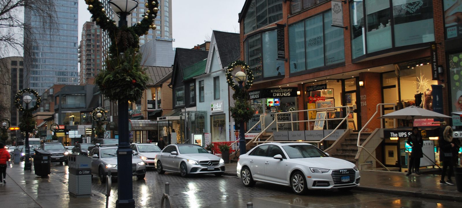
Cumberland Street in Yorkville on a rainy day, with shops in old houses and towers behind
Cumberland Street, Yorkville.
Photo: Enoch Leung from Canada, CC BY-SA 2.0

About The Annex to Rosedale

North of Bloor Street the old city changes again. Here are some of Toronto’s oldest suburbs, laid out on the estates of the town’s first families in the 1800s and joined to the city as it grew north. The Annex and Yorkville sit on either side of Avenue Road, Rosedale and Moore Park wind around the ravines east of Yonge Street, and Summerhill and Deer Park climb toward St. Clair Avenue.

Homes are mostly freehold, from Victorian and Edwardian semis to large detached houses, with low and mid rise apartments and condos along Bloor Street, Avenue Road, and Yonge Street. Lines 1 and 2 meet at Bloor-Yonge and St. George, so the subway is close almost everywhere.

Schools. Public schools are run by the Toronto District School Board and Catholic schools by the Toronto Catholic District School Board, with French language schools from Conseil scolaire Viamonde and MonAvenir, and this part of the city also has several well known independent schools. Catchments follow the address, so it is worth checking one with the board.

Bloor Street to Dupont Street, Bathurst Street to Avenue Road

The Annex

The Annex runs north from Bloor Street to Dupont Street, between Bathurst Street and Avenue Road. It borders the University of Toronto’s St. George campus, so it has long been a student quarter and home to many of the university’s faculty. The City’s own Annex neighbourhood is larger and takes in Seaton Village and Yorkville as well.

The streets are lined with tall trees over large Victorian and Edwardian houses, most of them built between 1880 and the early 1900s. Many are in the Romanesque Revival style that gives the Annex its look, with deep porches, turrets, and red sandstone and brick. In the 1950s and 1960s some houses were replaced with apartment buildings, and a large share of what is left is now protected by heritage designation.

Homes

Large detached and semi detached Victorian and Edwardian houses, many divided into flats and others restored as single family homes, with mid rise rental buildings from the postwar years and condos along Bloor Street and Avenue Road.

Streets and landmarks

Bloor Street between Avenue Road and Bathurst Street has restaurants, bookshops, and the Hot Docs Ted Rogers Cinema, with homes above many of the shops. Spadina Road and Huron Street run north through the middle.

Parks and green space

Taddle Creek Park, Jean Sibelius Square, and Ramsden Park, which is at the east end along Yonge Street.

Getting around

Bloor Street has Spadina, St. George, and Bathurst stations on Line 2, with Spadina and St. George also on Line 1, and Dupont station is at the north edge.

Day to day

Bloor Street’s bookshops, cafés, and the Hot Docs cinema are a short walk, and the university is at the foot of the street. The side streets are quiet and treed.

On the City’s neighbourhood map: Annex. A smaller local name here is Mirvish Village.

Bloor Street to the railway, Bathurst Street to Christie Street

Seaton Village

Seaton Village is a former village west of the Annex, named for John Colborne, Lord Seaton, Lieutenant Governor of Upper Canada from 1828 to 1836. It runs from Bloor Street up to the Canadian Pacific tracks, between Bathurst Street and Christie Street, and it is sometimes called the West Annex. It shares a lot with the Annex but is often seen as quieter and more family oriented.

Homes

Mostly semi detached single family houses from the start of the 20th century, many of solid brick, with mature trees planted when the houses were built.

Streets and landmarks

Bloor Street along the south edge has the shops and restaurants of Koreatown, and Christie Pits is at the southwest corner.

Parks and green space

Vermont Square Park, near the middle of the village, has a playground, off leash dog hours, an arena, and the St. Alban’s Boys and Girls Club. Christie Pits is close by.

Getting around

Christie and Bathurst stations on Line 2 are on Bloor Street, and Dupont station on Line 1 is a short walk east of the north end.

Day to day

Christie Pits and Vermont Square are the local parks, and the shops and subway on Bloor Street are a block or two south.

On the City’s neighbourhood map: Annex.

Bloor Street to Davenport Road, Avenue Road to Yonge Street

Yorkville

Yorkville is a former village founded in 1830 by Joseph Bloor, for whom Bloor Street is named, and William Botsford Jarvis. It was annexed by Toronto in 1883. It runs from Bloor Street up to Davenport Road, between Avenue Road and Yonge Street, and today it mixes homes, offices, and some of the most expensive shopping in the country.

The Mink Mile, the stretch of Bloor Street West with the luxury brands and the big department stores, is here. In the 1960s Yorkville was the centre of the city’s folk music and counterculture scene, and its little Victorian houses later became galleries, boutiques, and restaurants.

Homes

Mostly condos, many of them in the city’s most expensive towers, along with Victorian row houses and townhouses on side streets such as Hazelton Avenue and Berryman Street.

Streets and landmarks

Yorkville Avenue and Cumberland Street have the galleries and restaurants, and the Royal Ontario Museum is at the southwest corner, at Bloor Street and Queen’s Park.

Parks and green space

The Village of Yorkville Park, on Cumberland Street, is built in a row of small gardens, with a large granite rock at its centre. Ramsden Park is a short walk north.

Getting around

Bay and Bloor-Yonge stations are on Bloor Street, St. George is at the west end, and Lines 1 and 2 meet at Bloor-Yonge.

Day to day

Most things are within walking distance: the shops of Bloor Street and Yorkville Avenue, the Royal Ontario Museum, galleries, and restaurants. Two subway lines and the Village of Yorkville Park are right in the neighbourhood.

On the City’s neighbourhood map: Annex.

East of Yonge Street, around the ravines

Rosedale and Moore Park

Rosedale was the estate of William Botsford Jarvis, and it was named by his wife, Mary, for the wild roses that grew here. It is one of the city’s oldest suburbs, built among three ravines that are preserved as parkland. The ravines, the bridges, and a maze of crescents and dead ends keep through traffic low, which is part of its appeal.

South Rosedale is the older part, closer to Bloor Street. North Rosedale, past the Park Drive ravine, has slightly newer houses. Moore Park, farther north on either side of St. Clair Avenue East, takes its name from its developer, John T. Moore, who built two bridges in 1891 to win buyers across the ravines.

Homes

Large detached houses on generous lots, from Victorian and Edwardian houses in South Rosedale to Georgian and Tudor Revival houses farther north, with some semis and a handful of low rise apartments near Yonge Street. Much of South Rosedale is a heritage conservation district, which shapes what owners can change.

Streets and landmarks

Chorley Park, in North Rosedale, is the site of the old Government House built in 1915 for the Lieutenant Governor and torn down in the early 1960s. Mount Pleasant Cemetery is along the north edge of Moore Park.

Parks and green space

The Rosedale ravines, David A. Balfour Park, Craigleigh Gardens, Chorley Park, and Rosedale Park, with its rink and tennis courts. The trails lead down to the Evergreen Brick Works in the Don Valley.

Getting around

Rosedale station on Line 1 is at Yonge Street and Crescent Road, Castle Frank and Sherbourne stations on Line 2 are at the south, and Summerhill and St. Clair stations are close to the west side.

Day to day

The ravine trails are a few minutes from most streets, the shops on Yonge Street near Rosedale station cover daily errands, and the subway is a few stops from downtown.

On the City’s neighbourhood map: Rosedale-Moore Park.

Yonge Street, between Rosedale and Deer Park

Summerhill

Summerhill is named for Summer Hill, the house Charles Thompson built in 1842. The neighbourhood grew up in the 1880s around the North Toronto railway station on Yonge Street, which was rebuilt in 1916 and lost its regular passenger trains in 1930. Growth was slow after that, until Summerhill station opened on the Yonge subway in 1954.

The old station building, with its clock tower, is now a well known LCBO store, and the stretch of Yonge Street around it has a village feel, with food shops, restaurants, and small boutiques.

Homes

Victorian and Edwardian semis and row houses on narrow streets on either side of Yonge Street, some detached houses, and a few low rise condos and townhouses.

Parks and green space

Ramsden Park is just south, and the Rosedale ravines and the Kay Gardner Beltline Park are close.

Getting around

Summerhill station on Line 1 is right on Yonge Street, with Rosedale and St. Clair stations either side.

Day to day

Yonge Street here has food shops and the old station, now an LCBO, with quiet side streets, Ramsden Park, and the subway at the corner.

On the City’s neighbourhood map: Rosedale-Moore Park, Yonge-St.Clair.

Yonge Street and St. Clair Avenue

Deer Park

Deer Park is centred on Yonge Street and St. Clair Avenue. It reaches east to the Vale of Avoca in the Rosedale ravine, west to Avenue Road and Oriole Parkway, and north to the Beltline Trail. It was annexed by the City of Toronto in 1908, and by the 1930s it had become the comfortable residential district it still is.

The corner of Yonge Street and St. Clair Avenue is a busy hub of office and apartment towers, while the streets away from it are quiet and residential. De La Salle College has been at Oaklands, the old estate of Senator John Macdonald, since 1931.

Homes

One of the denser parts of midtown, with many rental and condo apartment towers near Yonge Street and St. Clair Avenue, and detached and semi detached houses on the side streets and up the hill toward Avenue Road.

Parks and green space

The Kay Gardner Beltline Park runs along the north edge, David A. Balfour Park and the ravine trails are to the east, and Lionel Conacher Park is a local green.

Getting around

St. Clair station on Line 1 is at the corner, and the 512 St. Clair streetcar runs west along St. Clair Avenue from there.

Day to day

Towers along Yonge Street and St. Clair Avenue sit beside quiet streets of houses, the subway is at St. Clair, and the Kay Gardner Beltline Park and the ravines are a short walk away.

On the City’s neighbourhood map: Yonge-St.Clair, Rosedale-Moore Park.

Sources

We wrote this guide from the public sources listed here, and checked each fact against at least two of them. Neighbourhood names follow local usage, and the City of Toronto’s 158 official neighbourhoods are listed under each entry. The streets named are examples rather than boundaries. Details such as school catchments, zoning, and transit routes change, so please check anything important with the City, the TTC, or the school board.