Toronto · Scarborough

Scarborough

Houses on top of the Bluffs, quiet streets by the Rouge, and some of the best food in the city along its main roads.

Map of Scarborough in Toronto: the City’s neighbourhoods in this part of the city are shaded, with the subway and LRT lines, main roads, parks, and ravines. Each neighbourhood in this guide is marked; choose one to jump to it.Aga Khan Park & MuseumBirchmountBroadviewCoxwellDon MillsLairdLeslieMain StreetSunnybrook ParkWardenBirch CliffCliffcrestGuildwoodWest Hill, Highland Creek,Port UnionRouge and MalvernAgincourt, L’Amoreaux,Scarborough City CentreWexford
Point to a neighbourhood or tap it; tap again to open itCity of Toronto Open Data and OpenStreetMap
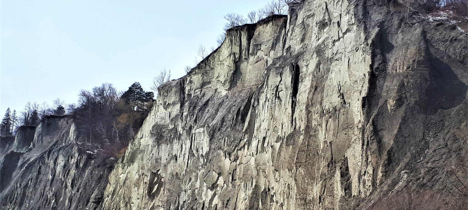
The pale, steep face of the Scarborough Bluffs at Bluffer’s Park
The Scarborough Bluffs at Bluffer’s Park.
Photo: Mhsheikholeslami, CC BY-SA 4.0

About Scarborough

Scarborough is the eastern part of the city, from Victoria Park Avenue to the Rouge River and from the lake to Steeles Avenue. It takes its name from the English town, chosen in 1793 by Elizabeth Simcoe because the cliffs reminded her of it. The Scarborough Bluffs rise up to 90 metres above the lake for about 15 kilometres, and Bluffer’s Park is the one park below them with a beach.

Most of Scarborough was built after the Second World War, so its neighbourhoods are mostly detached bungalows, back splits, and two storey houses, with apartment towers and townhouses along the main roads. It is one of the most diverse parts of the city, and its plazas are known for food from around the world.

Scarborough has golf as well, from the City’s Tam O’Shanter course to the private Scarboro club, which opened in 1912.

Schools. Public schools are run by the Toronto District School Board and Catholic schools by the Toronto Catholic District School Board, with French language schools from Conseil scolaire Viamonde and MonAvenir. Catchments follow the address, so it is worth checking one with the board before you buy.

Kingston Road, Victoria Park Avenue to Brimley Road

Birch Cliff and Cliffside

Birch Cliff, along the top of the western Bluffs, grew up around the Toronto Hunt Club, which arrived in 1895 when the area was still farms and woods. One of the cottages built near the club was named Birch Cliff, for the birches along the edge of the cliffs, and the post office and the neighbourhood took its name. Cliffside, to the east, was built as a postwar subdivision in the early 1950s.

Kingston Road is the main street, with shops, restaurants, and some newer mid rise condos.

Homes

Detached houses, from early 1900s cottages and older houses near the lake to postwar bungalows, with some newer infill houses and mid rise condos along Kingston Road.

Parks and green space

Rosetta McClain Gardens on the edge of the Bluffs, Scarborough Heights Park, Birchmount Park, and the Bluffs trails.

Getting around

Scarborough GO station on the Lakeshore East line, buses along Kingston Road, and Victoria Park and Warden stations on Line 2 to the north.

Day to day

Kingston Road has the shops, the Bluffs are at the end of many streets, and Rosetta McClain Gardens overlooks the lake.

On the City’s neighbourhood map: Birchcliffe-Cliffside, Oakridge, Clairlea-Birchmount.

Along the Bluffs, Midland Avenue to Markham Road

Cliffcrest and Scarborough Village

Cliffcrest runs along the top of the Bluffs from Midland Avenue east to Bellamy Road, and its name refers to the cliffs. Many of its houses are smaller, cottage like detached houses on deep lots, and some streets look more like cottage country than the city. Below it, Bluffer’s Park has the only beach at the foot of the Bluffs, along with a marina and trails.

Scarborough Village, to the east, has ravines such as Gates Gully running down to the lake, and the Scarboro golf club along Kingston Road.

Homes

Mostly detached houses with a high share of owners, from small postwar bungalows to larger houses on cliff top lots, with few high or mid rise buildings.

Parks and green space

Bluffer’s Park, Cathedral Bluffs Park, Sylvan Park and Gates Gully, and the Bluffs trails.

Getting around

Eglinton and Guildwood GO stations on the Lakeshore East line, Kennedy station, where Line 2 meets Line 5 Eglinton and the Stouffville GO line, and buses along Kingston Road.

Day to day

Bluffer’s Park and the Bluffs trails are close, the lots are deep, and the streets near the lake are quiet.

On the City’s neighbourhood map: Cliffcrest, Scarborough Village, Kennedy Park, Eglinton East, Ionview.

South of Kingston Road, on the Bluffs

Guildwood

Guildwood Village grew out of the Guild Inn estate, built as a country house in 1914, which Rosa and Spencer Clark turned into an artists’ colony and inn from 1932. In the 1950s the Clarks sold much of their land for the Guildwood Village subdivision. Guild Park and Gardens, on the Bluffs, is known for its collection of architectural fragments saved from demolished downtown buildings.

The Osterhout Log Cabin, on the Bluffs, is one of the oldest buildings still standing in the city, though its exact age is unknown.

Homes

Mostly detached houses from the 1950s and 1960s on curving, treed streets, many on large lots near the Bluffs.

Parks and green space

Guild Park and Gardens and the Bluffs trails, with East Point Park to the east.

Getting around

Guildwood GO station on the Lakeshore East line, also served by VIA Rail, and buses along Kingston Road.

Day to day

Guild Park and Gardens, quiet streets, and the lake, with Guildwood GO and VIA for the trip downtown.

On the City’s neighbourhood map: Guildwood.

Around the Highland Creek valley

West Hill, Highland Creek, and Morningside

West Hill takes its name from its high ground on the west side of the Highland Creek ravine, and the part east of Manse Road is often called Manse Valley. Highland Creek, to the east, has old shops and a church on Old Kingston Road, and its western side is home to the University of Toronto Scarborough campus, with the Toronto Pan Am Sports Centre beside it.

Homes

Postwar detached houses and bungalows, townhouses, and apartment towers along Kingston Road and Lawrence Avenue East.

Parks and green space

Morningside Park in the Highland Creek valley, Colonel Danforth Park, and East Point Park on the lake.

Getting around

Guildwood GO to the south, buses to Kennedy and Scarborough Centre, and the 401 close by.

Schools

The University of Toronto Scarborough and Centennial College’s Morningside campus are nearby.

Day to day

The Highland Creek ravines and trails, the University of Toronto Scarborough and the Toronto Pan Am Sports Centre close by, and Kingston Road for errands.

On the City’s neighbourhood map: West Hill, Highland Creek, Morningside, Woburn North, Golfdale-Cedarbrae-Woburn.

Kingston Road to the lake, Highland Creek to the Rouge

Port Union and West Rouge

Port Union, also called Centennial Scarborough, began as a small 19th century lakefront town and grew into a postwar bedroom community. Since the 1990s, old industrial land on the waterfront has turned into new subdivisions, with a paved path along the lake. West Rouge, beside the Rouge River, was part of Pickering Township until 1974.

Homes

Mostly detached houses with a high share of owners, from postwar bungalows to newer two storey houses near the lake.

Parks and green space

The Port Union Waterfront Park trail, Rouge Beach at the mouth of the Rouge River, and Rouge National Urban Park.

Getting around

Rouge Hill GO station on the Lakeshore East line, and the 401 close by.

Day to day

Rouge Beach and the waterfront trail, Rouge Hill GO for the train downtown, and quiet streets near the lake.

On the City’s neighbourhood map: Centennial Scarborough, West Rouge.

The northeast corner, around the Rouge valley

Rouge and Malvern

Malvern began in 1856 as a post office in a general store at Finch Avenue and Markham Road, named for the English resort town. Today it is a large, diverse community, and among the youngest in the country.

East of it, Morningside Heights, the City’s name for the Rouge area and one of its largest neighbourhoods by area, has newer suburban houses north of Sheppard Avenue and a huge stretch of protected land in Rouge National Urban Park, along with the Toronto Zoo.

Homes

Detached and semi detached houses and townhouses from the 1970s on, with newer subdivisions in Morningside Heights and apartment towers in Malvern.

Parks and green space

Rouge National Urban Park, the Toronto Zoo, and Malvern Park.

Getting around

Buses to Kennedy and Scarborough Centre, and the 401 close by. An extension of Line 2 north to Sheppard Avenue and McCowan Road is under construction.

Day to day

Rouge National Urban Park and the Toronto Zoo are close, with trails, campgrounds, and farmland at the edge of the city.

On the City’s neighbourhood map: Malvern East, Malvern West, Morningside Heights. A smaller local name here is Armadale.

Sheppard Avenue East north to Steeles

Agincourt, L’Amoreaux, and Milliken

Agincourt was a village on Sheppard Avenue East and today gives its name to a large part of northwest Scarborough. Agincourt Mall is in Tam O’Shanter, to the west. To the north, L’Amoreaux and Milliken run up to Steeles Avenue, with many malls and plazas known for Chinese, South Asian, and other foods from around the world.

Homes

Postwar detached houses, back splits, and semis, along with townhouse complexes and condo towers near Sheppard Avenue and Steeles Avenue.

Parks and green space

L’Amoreaux North Park, Milliken Park, Brimley Woods, and the Highland Creek trails.

Getting around

Agincourt and Milliken GO stations on the Stouffville line, buses along Sheppard and Finch, and the 401 and the 404.

Day to day

Malls and plazas with food from all over the world, Agincourt and Milliken GO, and parks such as L’Amoreaux North Park and Milliken Park.

On the City’s neighbourhood map: Agincourt North, Agincourt South-Malvern West, Tam O’Shanter-Sullivan, L’Amoreaux West, East L’Amoreaux, Steeles, Milliken. A smaller local name here is Bridlewood.

McCowan Road and the 401

Scarborough City Centre

Scarborough City Centre was the downtown of the old City of Scarborough, and it is still one of the main business districts outside the core. At its heart are the Scarborough Civic Centre, Albert Campbell Square, and Scarborough Town Centre, with condo towers around them.

Line 3 closed in 2023, and buses now link Scarborough Centre with Kennedy station. The Line 2 extension under construction is planned to have a station here.

Homes

Condo towers around the Civic Centre and the mall, and postwar houses in Bendale and Dorset Park.

Parks and green space

Albert Campbell Square, Thomson Memorial Park, and the Highland Creek ravines.

Getting around

A large bus terminal at Scarborough Centre and the 401 at the door.

Day to day

Scarborough Town Centre, the Civic Centre and Albert Campbell Square, the 401, and the Line 2 extension being built.

On the City’s neighbourhood map: Bendale-Glen Andrew, Bendale South, Dorset Park.

Lawrence Avenue East and Eglinton Avenue East, west Scarborough

Wexford and the Golden Mile

Wexford, named for County Wexford in Ireland, spans Lawrence Avenue East between Victoria Park Avenue and Birchmount Road. The Church of St. Jude, built in 1848, survives from the old village. The Wexford Heights BIA runs the Taste of Lawrence street festival each summer.

To the south, the Golden Mile along Eglinton Avenue East grew as a postwar industrial and shopping strip, and it is now being rebuilt around the Line 5 Eglinton stops.

Homes

Postwar bungalows and semis, with apartment buildings on the main roads and new condos planned around the Golden Mile.

Parks and green space

Wexford Park, Warden Woods Park, and the Taylor Massey Creek trails.

Getting around

Line 5 Eglinton has stops at Pharmacy, Hakimi Lebovic, Golden Mile, and Birchmount, and Victoria Park and Warden stations on Line 2 are to the south.

Day to day

Lawrence Avenue East’s shops and the Taste of Lawrence festival in summer, and Line 5 Eglinton close by to the south.

On the City’s neighbourhood map: Wexford/Maryvale, Clairlea-Birchmount, Ionview.