Toronto · Midtown

Midtown

Garden suburbs, castle views, and the busy corner of Yonge and Eglinton, now crossed by the Eglinton line.

Map of Midtown in Toronto: the City’s neighbourhoods in this part of the city are shaded, with the subway and LRT lines, main roads, parks, and ravines. Each neighbourhood in this guide is marked; choose one to jump to it.AvenueBathurstBayBloor-YongeBroadviewCastle FrankCedarvaleChaplinDavisvilleDon ValleyDonlandsDupontFairbankGlencairnLairdLawrenceLawrence WestLeasideMuseumPapeRosedaleSpadinaSt. ClairSt. Clair WestSummerhillSunnybrook ParkWellesleyWilsonYork MillsYorkdaleForest HillSouth Hill and Casa LomaWychwood and HillcrestYonge and EglintonDavisville VillageLeasideLawrence ParkBedford Park
Point to a neighbourhood or tap it; tap again to open itCity of Toronto Open Data and OpenStreetMap
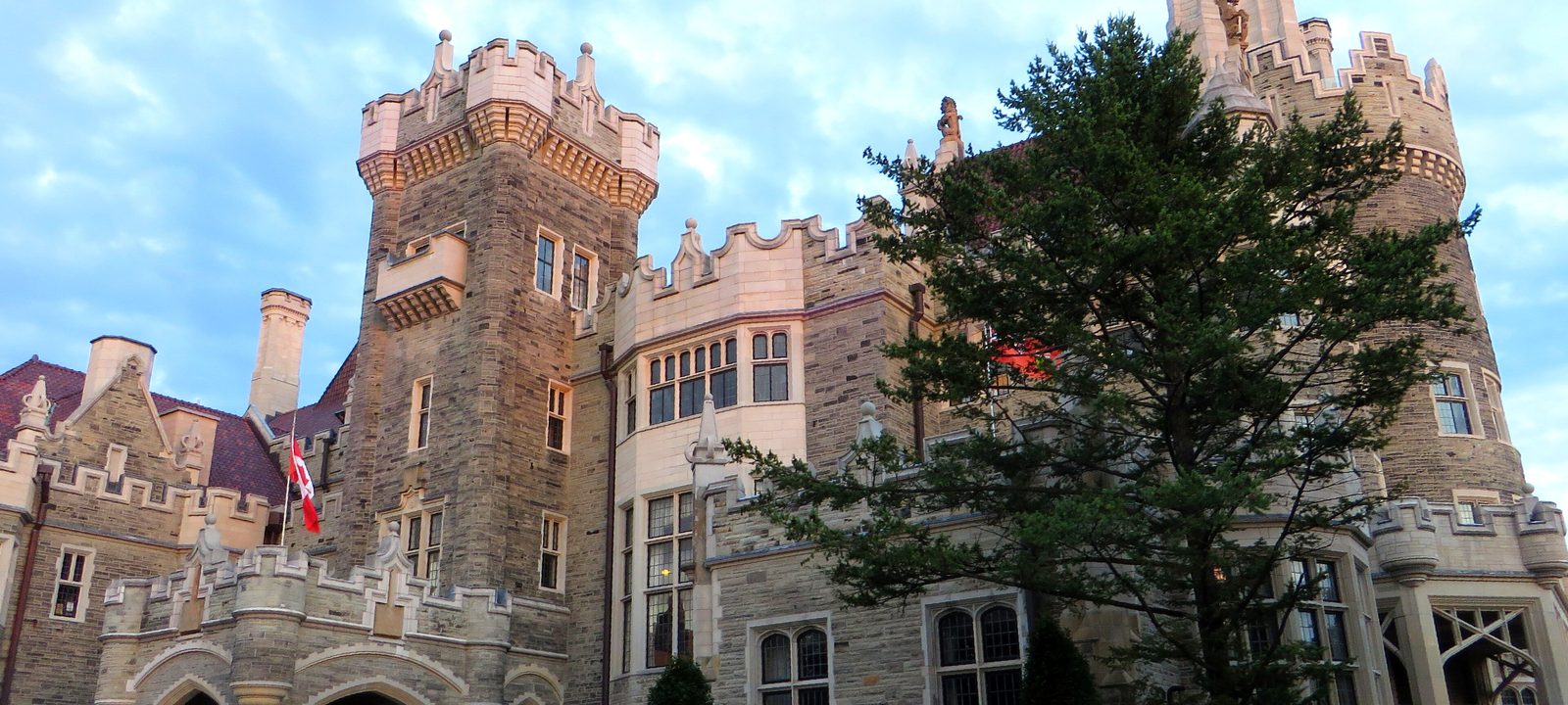
The stone towers of Casa Loma behind a large evergreen, under a blue sky
Casa Loma, on the hill above Davenport Road.
Photo: Ken Lund from Reno, Nevada, USA, CC BY-SA 2.0

About Midtown

Midtown is the band of the city between about St. Clair Avenue and Lawrence Avenue, from Bathurst Street east to the Don Valley. Much of it was built as streetcar suburbs and planned garden suburbs in the early 20th century, and it is still mostly houses on quiet streets, with taller buildings gathering along Yonge Street, Eglinton Avenue, and St. Clair Avenue.

Line 1 runs up Yonge Street, and since February 2026 Line 5 Eglinton has run across the middle of midtown, connecting with Line 1 at Eglinton and at Cedarvale. Mount Pleasant Cemetery, the Beltline Trail, and the ravines give midtown more green space than its density would suggest.

Schools. Public schools are run by the Toronto District School Board and Catholic schools by the Toronto Catholic District School Board, with French language schools from Conseil scolaire Viamonde and MonAvenir. Midtown also has many independent schools. Popular public schools can fill, so it is worth checking an address with the board before you buy.

Avenue Road to Bathurst Street, around Spadina Road

Forest Hill

Forest Hill was its own village, incorporated in 1923 and joined to the City of Toronto in 1967. It was named for the summer home of John Wickson. Along with Rosedale and the Bridle Path, it is one of the city’s wealthiest neighbourhoods.

Its two halves are often called Lower and Upper Forest Hill. The shops of the Lower Village are on Spadina Road near Heath Street, and the Upper Village is on Eglinton Avenue West around Spadina Road. In the late 1960s Forest Hill and the Annex fought the planned Spadina Expressway, which would have run down the Cedarvale Ravine and Spadina Road. It was cancelled in 1971.

Homes

Large detached houses, many of them Georgian, Tudor, and English cottage styles from the 1920s and 1930s, on wide lots with mature trees. Some have been replaced with larger new houses. There are low rise apartments and condos along Spadina Road, Bathurst Street, and Eglinton Avenue.

Streets and landmarks

Spadina Road is the main street of Lower Forest Hill. Upper Canada College and Bishop Strachan School, two of the city’s best known independent schools, are here, along with Forest Hill Collegiate Institute, a public high school.

Parks and green space

Cedarvale Ravine runs along the west edge, the Kay Gardner Beltline Park crosses the middle, and Forest Hill Road Park and Suydam Park are local greens.

Getting around

Line 5 Eglinton has Forest Hill and Chaplin stops on Eglinton Avenue, with Cedarvale station at Allen Road, where it meets Line 1. St. Clair West station on Line 1 is at the south edge.

Day to day

The Cedarvale Ravine and the Beltline are close for walks, the Village on Spadina Road has the daily shops, and several well known public and independent schools are nearby.

On the City’s neighbourhood map: Forest Hill South, Forest Hill North.

Above Davenport Road, Bathurst Street to Yonge Street

South Hill and Casa Loma

Casa Loma, Spanish for hill house, is the Gothic Revival castle Sir Henry Pellatt built between 1911 and 1914 on the old shoreline bluff above Davenport Road. E. J. Lennox was the architect. Pellatt lost it within about a decade, and it is now a historic house museum owned by the City.

The City’s Casa Loma neighbourhood runs from the rail tracks up to St. Clair Avenue West, between Bathurst Street and Spadina Road. East of Spadina Road, South Hill climbs the same hill toward Avenue Road and Poplar Plains Road. The castle’s fame drew a building boom of large houses around it.

Homes

Large detached houses and semis from the early 20th century, many on the slope with views south over the city, with some low rise apartments and condos near St. Clair Avenue West and Avenue Road.

Streets and landmarks

The Baldwin Steps climb from Davenport Road to Spadina House, a museum beside Casa Loma, and Austin Terrace runs past the castle.

Parks and green space

Sir Winston Churchill Park, on St. Clair Avenue West, sits over a reservoir and leads into the Nordheimer Ravine. Wells Hill Park and Roycroft Park are close.

Getting around

Dupont and St. Clair West stations on Line 1 are at the bottom and top of the hill, and the 512 St. Clair streetcar runs along St. Clair Avenue West.

Day to day

The castle and Spadina House are neighbours, the Baldwin Steps lead down to Davenport Road, and the hilltop streets are quiet, with views back over the city.

On the City’s neighbourhood map: Casa Loma, Yonge-St.Clair.

Bathurst Street to Christie Street, Davenport Road to St. Clair Avenue

Wychwood and Hillcrest

The City’s Wychwood neighbourhood takes its name from Wychwood Park, a private enclave on the north side of Davenport Road, west of Bathurst Street. It was founded as an artists’ colony in the late 1800s by the painter Marmaduke Matthews and the businessman Alexander Jardine, with irregular lots around a central pond. It joined the City in 1909 and is still a private community, with its roads paid for by the residents. Marshall McLuhan lived there.

Around it, Hillcrest and the streets toward St. Clair Avenue West are busy family neighbourhoods. The Wychwood Barns, old streetcar repair barns, now hold artist studios, a greenhouse, and a weekly farmers’ market.

Homes

Detached and semi detached houses from the early 20th century, many with front porches, and the Arts and Crafts houses of Wychwood Park itself. There are a few low rise apartments along St. Clair Avenue West.

Streets and landmarks

St. Clair Avenue West has the shops and restaurants along the north edge, and Geary Avenue, at the south, has become a street of bakeries, studios, and small breweries.

Parks and green space

Wychwood Barns Park, Hillcrest Park, and the Garrison Creek Park, with the ravine at Nordheimer close by.

Getting around

The 512 St. Clair streetcar runs along the top, St. Clair West station on Line 1 is at the northeast corner, and Dupont station is at the southeast.

Day to day

The Wychwood Barns hold a Saturday farmers’ market and artists’ studios, and St. Clair Avenue West’s shops and the 512 streetcar are a short walk north.

On the City’s neighbourhood map: Wychwood.

Midtown’s centre

Yonge and Eglinton

Yonge and Eglinton, once part of the Town of North Toronto, is the centre of midtown and one of the city’s business districts outside the core. Canadian Tire and TVOntario have their head offices at the intersection, around the Canada Square towers and the Yonge Eglinton Centre.

The area has grown fast, with condo towers rising on and near Yonge Street and Eglinton Avenue. Behind the main streets, many side streets are still lined with detached and semi detached houses, which gives the neighbourhood its mix of busy and quiet. Its old nickname, Young and Eligible, is a play on the names of the two streets.

Homes

Condo towers, both new and older, near the intersection, with detached and semi detached houses from the 1910s to the 1930s on the side streets, among them Chaplin Estates and the streets around Eglinton Park.

Streets and landmarks

Yonge Street has shops and restaurants for blocks in both directions, and Eglinton Avenue has more to the west. Mount Pleasant Road and Bayview Avenue have their own strips of local shops to the east.

Parks and green space

Eglinton Park, with its sports fields and the North Toronto Memorial Community Centre, Oriole Park, and the Kay Gardner Beltline Park.

Getting around

Eglinton station is where Line 1 meets Line 5 Eglinton, which opened in February 2026 and runs east to Kennedy and west to Mount Dennis. Davisville station is just south.

Day to day

Two subway lines meet at the corner, with shops, a cinema, and restaurants around it, and Eglinton Park, its sports fields, and the North Toronto Memorial Community Centre a short walk west.

On the City’s neighbourhood map: Yonge-Eglinton, South Eglinton-Davisville, North Toronto.

Between St. Clair Avenue and Eglinton Avenue

Davisville Village and Chaplin Estates

Davisville was founded by John Davis, who opened its first post office in 1840 and started the Davisville Pottery Company, for years the area’s largest employer. Today Davisville Village is centred on Davisville Avenue and Yonge Street, right beside Mount Pleasant Cemetery. Many large apartment and condo buildings went up here between the 1970s and the 2000s.

Chaplin Estates covers the southwest part of the Yonge and Eglinton area, west of Yonge Street, between Eglinton Avenue and Chaplin Crescent, which follows the old Beltline railway. East of Mount Pleasant Road, the City’s Mount Pleasant East neighbourhood takes in the streets around Sherwood Park.

Homes

Apartment and condo towers along Davisville Avenue and Yonge Street, and detached and semi detached houses on the side streets, the Chaplin Estates houses among the larger of them.

Streets and landmarks

Mount Pleasant Cemetery, one of the city’s great green spaces, is along the south edge, and Mount Pleasant Road and Bayview Avenue have local shops.

Parks and green space

June Rowlands Park, Sherwood Park with its ravine, and the Kay Gardner Beltline Park, which runs along Chaplin Crescent on the old rail line.

Getting around

Davisville station on Line 1 is at Yonge Street and Chaplin Crescent, with Eglinton station just north, and Line 5 Eglinton has a stop at Mount Pleasant Road.

Day to day

The Kay Gardner Beltline Park and Mount Pleasant Cemetery are close for walks, Bayview Avenue and Mount Pleasant Road have shops, and the subway is at Davisville.

On the City’s neighbourhood map: South Eglinton-Davisville, Mount Pleasant East, Yonge-Eglinton.

Bayview Avenue and Eglinton Avenue East

Leaside

Leaside takes its name from William Lea and the Lea family, who settled here in the early 1800s. In 1912 the owners of the Canadian Northern Railway hired the landscape architect Frederick Todd to plan a new town around their railway yard, with homes, shops, and a town centre west of Laird Drive and industry to the east. Leaside was incorporated as a town in 1913 and became part of East York in 1967.

It is close to Sunnybrook and the Don Valley, with a main street of shops along Bayview Avenue.

Homes

Mostly detached and semi detached houses, many built in the 1930s and 1940s, often in brick with Georgian or Tudor details. Many have been renovated or replaced with larger new houses. Low rise apartments and newer condos are along Eglinton Avenue and near Laird Drive.

Streets and landmarks

Bayview Avenue is the local main street, Laird Drive has the bigger stores, and the Leaside Memorial Community Gardens arena is on Millwood Road.

Parks and green space

Trace Manes Park, Howard Talbot Park, and the trails down into the Don Valley, Serena Gundy Park, Wilket Creek, and Sunnybrook Park.

Getting around

Line 5 Eglinton has Leaside and Laird stops on Eglinton Avenue East, and Davisville and Eglinton stations on Line 1 are a short bus ride west. The Don Valley Parkway is close.

Day to day

Bayview Avenue has the shops, there is an arena and sports fields, and Sunnybrook Park and the Don Valley trails are close.

On the City’s neighbourhood map: Leaside-Bennington. A smaller local name here is Governor’s Bridge.

Yonge Street to Bayview Avenue, Blythwood Ravine to Lawrence Avenue

Lawrence Park

Lawrence Park runs from Yonge Street to Bayview Avenue, from the Blythwood Ravine up to Lawrence Avenue. It was one of Toronto’s first planned garden suburbs, begun in the early 20th century but not fully built until after the Second World War. Its first advertisement called it an aristocratic neighbourhood, four hundred feet above Lake Ontario.

Howard and Lorrie Dunington-Grubb, who later founded Sheridan Nurseries, did much of the landscape work for its boulevards and parks. Lytton Park, around Lytton Boulevard on the west side of Yonge Street, is a neighbour with a similar feel.

Homes

Large detached houses on wide, deep lots, in English cottage, Tudor, and Georgian styles, on winding streets that follow the ravines. Many have been extended or rebuilt. There are condos along Yonge Street.

Parks and green space

The Blythwood, Chatsworth, and Lawrence Park ravines, Alexander Muir Memorial Gardens on Yonge Street, and Sherwood Park to the south.

Getting around

Lawrence station on Line 1 is at Yonge Street and Lawrence Avenue, and Eglinton station is a short ride south.

Schools

Lawrence Park Collegiate Institute and Northern Secondary School are well known public high schools in the area.

Day to day

Lots are large, the streets curve with the ravines, and Yonge Street and Alexander Muir Memorial Gardens are close.

On the City’s neighbourhood map: Lawrence Park South, Lawrence Park North.

Yonge Street, Lawrence Avenue to the 401

Bedford Park and North Toronto

Bedford Park began as a hamlet where farmers stopped on the way to market, and it was likely named for the Bedford Park Hotel, which opened in 1873 at Yonge Street and Fairlawn Avenue. In 1890 it joined Davisville and Eglinton to form the Town of North Toronto, which Toronto annexed in 1912. The name North Toronto is still used for the whole area.

Its first houses were built between 1890 and 1940 as a middle class suburb at the northern edge of the city, and Yonge Street between Lawrence Avenue and the 401 is lined with shops and restaurants.

Homes

Mid sized detached and semi detached houses from 1890 to 1940, with many newer replacement houses, and low rise condos along Yonge Street.

Parks and green space

Woburn Park, Ledbury Park, Brookdale Park, and the York Mills Valley to the north.

Getting around

Lawrence station on Line 1 is at the south end, and York Mills station is to the north.

Day to day

Yonge Street’s shops and restaurants are the main street, Lawrence station is close, and the side streets of older detached houses are quiet.

On the City’s neighbourhood map: Lawrence Park North, Bedford Park-Nortown, North Toronto. Smaller local names here include Wanless Park and Cricket Club.

Sources

We wrote this guide from the public sources listed here, and checked each fact against at least two of them. Neighbourhood names follow local usage, and the City of Toronto’s 158 official neighbourhoods are listed under each entry. The streets named are examples rather than boundaries. Details such as school catchments, zoning, and transit routes change, so please check anything important with the City, the TTC, or the school board.