Toronto · York and East York

York and East York

Two smaller former boroughs with brick houses from before the war, the Don and Humber valleys, and the new stops of Line 5 Eglinton.

Map of York and East York in Toronto: the City’s neighbourhoods in this part of the city are shaded, with the subway and LRT lines, main roads, parks, and ravines. Each neighbourhood in this guide is marked; choose one to jump to it.Aga Khan Park & MuseumAvenueBathurstBayBroadviewCollegeCoxwellDavisvilleDufferinDupontGlencairnHigh ParkIslingtonJaneKingKiplingLairdLawrenceLawrence WestMain StreetMount PleasantRosedaleSherbourneSt. ClairSt. PatrickSummerhillSunnybrook ParkWellesleyWilsonYork MillsYorkdaleOld East YorkWoodbine HeightsO’Connor-ParkviewThorncliffe ParkHumewood-CedarvaleOakwood Village, Fairbank,Mount DennisWestonBaby Point and Lambton
Point to a neighbourhood or tap it; tap again to open itCity of Toronto Open Data and OpenStreetMap
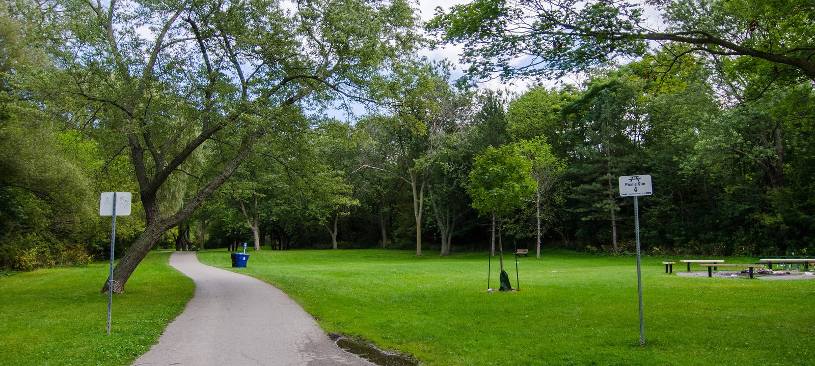
A paved path curving across a mown meadow under tall trees in Taylor Creek Park
Taylor Creek Park, East York.
Photo: Jeff Hitchcock from Seattle, WA, USA, CC BY 2.0

About York and East York

East York and York were the two smallest of the six municipalities that joined in 1998 to form today’s City of Toronto. East York, across the Don from the old city, was a borough from 1967 to 1998 and was Ontario’s last remaining borough. York, northwest of the old city, began as York Township and absorbed villages such as Weston and Lambton Mills before it became the City of York.

Both are close to the core, with plenty of brick houses built before the Second World War, and both have big valleys, the Don in East York and the Humber in York. Leaside, which was part of East York, is covered on our midtown page.

Schools. Public schools are run by the Toronto District School Board and Catholic schools by the Toronto Catholic District School Board, with French language schools from Conseil scolaire Viamonde and MonAvenir. Catchments follow the address, so it is worth checking one with the board before you buy.

North of the Danforth, the Don Valley to Victoria Park Avenue

Old East York and Pape Village

Old East York is the southern, urban part of the former borough, running just north of the Danforth from the Don Valley to Victoria Park Avenue. Most of it, especially south of Cosburn Avenue, was built before the Second World War on a walkable grid. It was first settled largely by British and Irish families and is now home to Greek, Bangladeshi, Chinese, and many other communities.

Pape Village is the small shopping street along Pape Avenue between Mortimer Avenue and Gamble Avenue, with cafés, restaurants, and local services, and many people use the name for the streets around it too.

Homes

Detached and semi detached brick houses and bungalows from the 1920s to the 1940s on modest lots, many renovated or rebuilt, with low rise apartments on the main streets.

Parks and green space

The Don Valley trails, Taylor Creek Park, and Stan Wadlow Park.

Getting around

Pape, Donlands, Greenwood, and Coxwell stations on Line 2 are a short walk south, and the Ontario Line is planned to stop at Cosburn Avenue and continue to Thorncliffe Park.

Day to day

Pape Village has the local shops, and the Danforth and Line 2 are a short walk south.

On the City’s neighbourhood map: Old East York, Danforth East York, Broadview North.

Woodbine Avenue to Victoria Park Avenue, above Taylor Creek

Woodbine Heights and Taylor-Massey

The eastern part of Old East York, around Woodbine Avenue, is often called Woodbine Heights. To the east, the City’s Taylor-Massey neighbourhood includes the Crescent Town towers beside Victoria Park station, built in the early 1970s.

Homes

Detached houses and semis from before and after the war on the side streets, with apartment towers at Crescent Town.

Parks and green space

Taylor Creek Park, a long ravine park running west to the Don, and Dentonia Park.

Getting around

Main Street and Victoria Park stations on Line 2, and Danforth GO on the Lakeshore East line.

Day to day

The subway at Woodbine and Main Street, Taylor Creek Park’s trails, and Stan Wadlow Park’s sports fields are all close.

On the City’s neighbourhood map: Woodbine-Lumsden, Taylor-Massey.

O’Connor Drive, north of Taylor Creek

O’Connor-Parkview

O’Connor-Parkview is the City’s name for the north end of East York, above Taylor Creek. Locals tend to use the smaller names inside it. Topham Park, in the northeast, was built by Wartime Housing Limited between 1944 and 1946, and Parkview Hills sits on wooded hills above the ravine.

Homes

Wartime and postwar bungalows and two storey houses, some on large lots, with apartment towers along O’Connor Drive and St. Clair Avenue East.

Parks and green space

Taylor Creek Park and Topham Park.

Getting around

Buses along O’Connor Drive and Woodbine Avenue to Line 2, and Line 5 Eglinton stops at O’Connor and Pharmacy to the north.

Day to day

Houses here have yards, and the Taylor Creek ravine trails are close.

On the City’s neighbourhood map: O’Connor-Parkview.

Inside the forks of the Don, south of Eglinton Avenue East

Thorncliffe Park and Flemingdon Park

Thorncliffe Park takes its name from Thorn Cliff House, an early family home at the forks of the Don. From 1920 the land was a racetrack, and after the last race in 1953 it was developed as a planned community of apartment towers. It is one of the most densely populated neighbourhoods in the city, with a large South Asian community.

Across the West Don, Flemingdon Park, officially in North York, is named for former Toronto mayor Robert John Fleming, whose family owned the farm there. It was planned in the late 1950s as an apartment city, with towers and townhouses from the early 1960s, and it has long been a first home for newcomers to Canada.

Homes

Mostly rental apartment towers, with some condos and townhouses, and new buildings planned near the coming transit.

Parks and green space

E. T. Seton Park, R. V. Burgess Park, and the Don Valley trails.

Getting around

Line 5 Eglinton has stops at Don Valley, Aga Khan Park & Museum, and Wynford, and the Ontario Line is planned to have stations at Thorncliffe Park and Flemingdon Park.

Day to day

Apartment towers sit around the shops and services of Thorncliffe Park Drive, with the Don Valley trails close and the Ontario Line being built nearby.

On the City’s neighbourhood map: Thorncliffe Park, Flemingdon Park.

Bathurst Street west to Arlington Avenue, St. Clair to Eglinton

Humewood-Cedarvale

Humewood-Cedarvale is two areas divided by Vaughan Road and Cedarvale Ravine. Humewood, to the south, is sometimes called the Woods for its many streets ending in wood, such as Humewood, Cherrywood, Valewood, and Pinewood. Cedarvale, to the north, runs up to Eglinton Avenue West.

Homes

Detached and semi detached brick houses from the 1910s to the 1930s, many with leaded windows and front porches, with apartment buildings on the main roads.

Parks and green space

Cedarvale Ravine, with its long path, Cedarvale Park, and Humewood Park.

Getting around

Cedarvale station, where Line 1 meets Line 5 Eglinton, and St. Clair West station to the south, with the 512 St. Clair streetcar.

Day to day

The Cedarvale Ravine trail runs through the middle, St. Clair West station is close, and Wychwood and Forest Hill are next door.

On the City’s neighbourhood map: Humewood-Cedarvale.

Eglinton Avenue West, Marlee Avenue to Keele Street

Oakwood Village, Fairbank, and Little Jamaica

Little Jamaica runs along Eglinton Avenue West from Marlee Avenue to Keele Street. Jamaican and Caribbean families began settling here in the late 1950s, and the street has long been a hub for Caribbean food, music, and businesses. Fairbank grew around a postal village at Dufferin Street and Eglinton, and Oakwood Village to the south, with its Five Points intersection, has a BIA and an arts festival.

Years of Eglinton construction were hard on the strip, and the new stops on Line 5 now serve it.

Homes

Detached and semi detached brick houses from the 1910s to the 1940s on modest lots, along with low rise apartments and some newer condos on Eglinton.

Parks and green space

Fairbank Memorial Park, Charles Caccia Park, and the York Beltline Trail to the north.

Getting around

Line 5 Eglinton stops at Oakwood, Fairbank, Caledonia, and Keelesdale, with buses north and south on Dufferin and Oakwood.

Day to day

Eglinton Avenue West has its Caribbean bakeries, record shops, and restaurants, and Line 5 Eglinton now runs underneath.

On the City’s neighbourhood map: Caledonia-Fairbank, Briar Hill-Belgravia, Keelesdale-Eglinton West, Oakwood Village. A smaller local name here is Silverthorn.

Eglinton Avenue West and Weston Road

Mount Dennis

Mount Dennis grew along Eglinton Avenue West between the Humber River and the rail line. Kodak bought land near Eglinton Avenue and Weston Road in 1913 and built its Canadian plant there, and the plant, known as Kodak Heights, defined the area for decades. Workers at Kodak, the nearby stockyards, and other factories built many of its houses. Part of the old Kodak site is now Mount Dennis station, the western end of Line 5 Eglinton.

Homes

Small detached houses and bungalows from the early to mid 1900s, with apartment towers on the main roads and new buildings planned near the station.

Parks and green space

The Humber River trails, Eglinton Flats, and Smythe Park.

Getting around

Mount Dennis station, the western end of Line 5 Eglinton, built beside the Kitchener rail line, and Weston GO and UP Express to the north.

Day to day

Line 5 Eglinton starts here at Mount Dennis station, and the Humber River trails, Eglinton Flats, and Smythe Park are close by.

On the City’s neighbourhood map: Mount Dennis, Rockcliffe-Smythe, Beechborough-Greenbrook. A smaller local name here is Eglinton Hill.

Weston Road, north of Lawrence Avenue West

Weston

Weston was a village in the 1800s on the east bank of the Humber, and it joined the Borough of York in the late 1960s. Its historic core is Weston Road just north of Lawrence Avenue West, with small shops and services, and a farmers’ market has long been held here.

Homes

Victorian and Edwardian houses on the older streets near the Humber, postwar houses, and apartment towers along Weston Road.

Parks and green space

The Humber River trails, Cruickshank Park, and Weston Lions Park.

Getting around

Weston GO station at Weston Road and Lawrence Avenue, on the Kitchener line and the Union Pearson Express, with Mount Dennis station on Line 5 to the south.

Day to day

Weston Road’s village shops and the Thursday farmers’ market, the Humber River trails below, and the UP Express to Union and Pearson from Weston station.

On the City’s neighbourhood map: Weston, Weston-Pelham Park. Smaller local names here include Carleton Village and St. Clair Gardens.

The Humber River at Jane Street and Dundas Street West

Baby Point and Lambton

Baby Point sits on a high bend of the Humber. It was once the site of Teiaiagon, a Seneca village of the late 1600s, and in the 1800s the land of James Baby, an Upper Canada official, after whom it is named. It was laid out as a residential enclave in the 20th century.

North of it, Lambton grew around the old Lambton Mills on the Humber. Lambton House on Old Dundas Street, once a hotel, is the last remnant of the village and is open part time as a museum.

Homes

Detached houses from the early 20th century in Baby Point, many on large lots above the river, and postwar houses in Lambton and Warren Park.

Parks and green space

The Humber River trails, Étienne Brûlé Park, and Magwood Park.

Getting around

Jane and Old Mill stations on Line 2 are close by, and Bloor West Village is a short walk south.

Day to day

Quiet streets above a bend in the Humber, with Étienne Brûlé Park below and Bloor West Village a short drive or walk away.

On the City’s neighbourhood map: Lambton Baby Point.

Sources

We wrote this guide from the public sources listed here, and checked each fact against at least two of them. Neighbourhood names follow local usage, and the City of Toronto’s 158 official neighbourhoods are listed under each entry. The streets named are examples rather than boundaries. Details such as school catchments, zoning, and transit routes change, so please check anything important with the City, the TTC, or the school board.