Toronto · Etobicoke

Etobicoke

Tudor style houses above the Humber, the old lakeshore towns, and the condo towers of Humber Bay Shores.

Map of Etobicoke in Toronto: the City’s neighbourhoods in this part of the city are shaded, with the subway and LRT lines, main roads, parks, and ravines. Each neighbourhood in this guide is marked; choose one to jump to it.AlbionCaledoniaCedarvaleDownsview ParkDriftwoodDufferinDuncanwoodsFinch WestGlencairnHigh ParkJaneKiplingLawrence WestMount DennisRoyal YorkSheppard WestSignet ArrowWilsonYork UniversityYorkdaleKingswayHumber Valley VillageIslington VillageHumber Bay ShoresMimicoNew TorontoLong BranchMarkland WoodRexdale
Point to a neighbourhood or tap it; tap again to open itCity of Toronto Open Data and OpenStreetMap
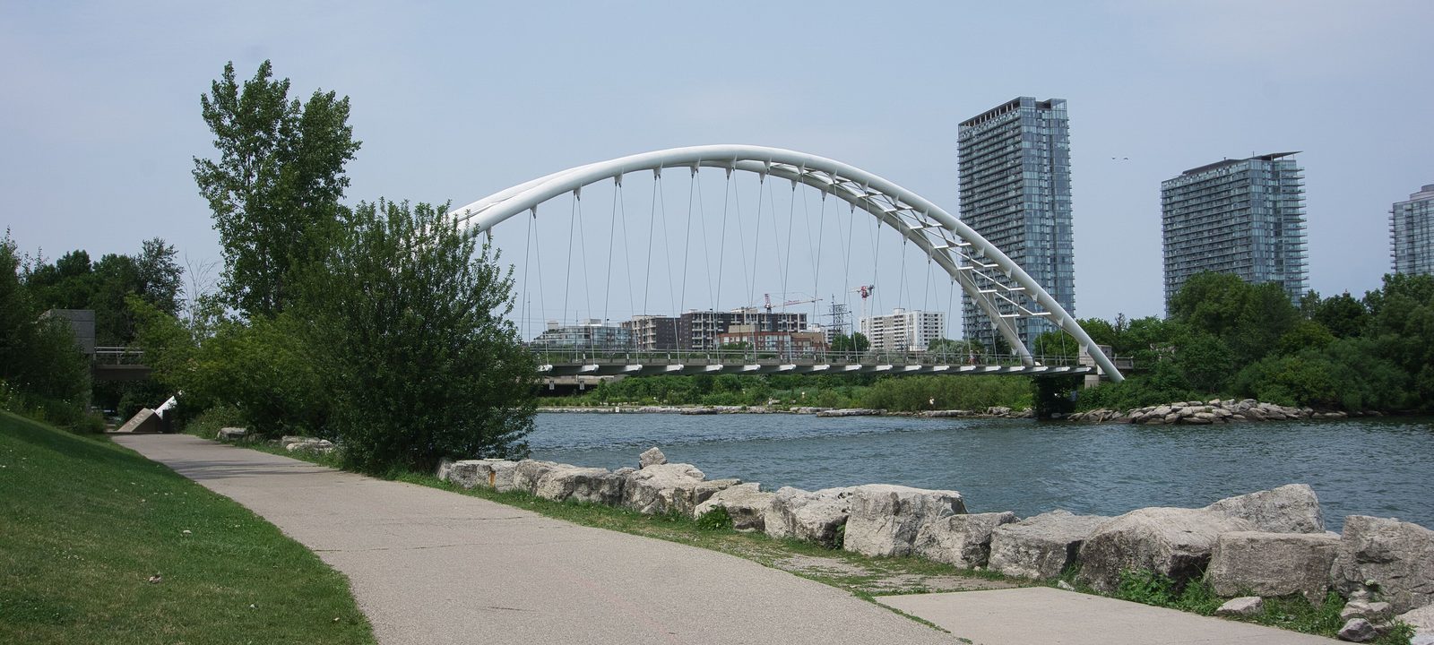
The Humber Bay Arch Bridge with the condo towers of Humber Bay Shores behind it
The Humber Bay Arch Bridge and Humber Bay Shores.
Photo: Chicken4War, CC BY-SA 4.0

About Etobicoke

Etobicoke is the western part of the city, from the Humber River west to Etobicoke Creek and north to Steeles Avenue. It became a township in 1850, and the three lakeshore towns of Mimico, New Toronto, and Long Branch were their own municipalities until 1967, when they joined it in a new Borough of Etobicoke. It became a city in 1984 and part of the new City of Toronto in 1998.

Its south end has some of the city’s older neighbourhoods, from the Kingsway above the Humber to the small lakeshore towns. The middle and north are mostly postwar suburbs, with Line 2 along Bloor Street, Lakeshore West and Milton GO lines, and Line 6 Finch West now reaching Humber College in the north.

Schools. Public schools are run by the Toronto District School Board and Catholic schools by the Toronto Catholic District School Board, with French language schools from Conseil scolaire Viamonde and MonAvenir. Catchments follow the address, so it is worth checking one with the board before you buy.

Bloor Street to Dundas Street, the Humber River to Mimico Creek

The Kingsway and the Old Mill

The Kingsway was laid out by Robert Home Smith, an Etobicoke lawyer who bought the old King’s Mill on the Humber in the early 1900s. Smith loved all things English, and by the 1920s his Kingsway Park was being built with English cottage and Tudor style houses, winding streets, and careful landscaping. The Old Mill, rebuilt as an inn, still stands at the bottom of the hill.

Bloor Street West through the Kingsway has a village feel, with shops, cafés, and restaurants. Sunnylea, south of Bloor beside Mimico Creek, is a quieter pocket of postwar houses.

Homes

Detached houses from the 1920s to the 1940s in English cottage, Tudor, and Georgian styles on treed lots, with some larger newer houses and a few condos on Bloor Street.

Streets and landmarks

Bloor Street West and Royal York Road are the main streets, and the Old Mill sits by the river.

Parks and green space

The Humber valley trails, Étienne Brûlé Park across the river, and the parks along Mimico Creek.

Getting around

Old Mill, Royal York, and Islington stations on Line 2 along Bloor Street, and the Gardiner and the QEW to the south.

Day to day

Tudor style houses, the Humber valley and the Old Mill close by, and Bloor Street’s shops and the subway at Royal York.

On the City’s neighbourhood map: Kingsway South, Edenbridge-Humber Valley, Stonegate-Queensway.

Dundas Street to Eglinton Avenue, Islington Avenue to the Humber

Humber Valley Village

Humber Valley Village runs from Dundas Street north to Eglinton Avenue, between Islington Avenue and the Humber River. It was little developed until Robert Home Smith built his own house, Edenbridge, above the valley and his company slowly subdivided the land. Smaller communities inside it include Chestnut Hills and Lincoln Woods.

To the east of Royal York Road, Frederick James bought land for his family estate in 1908, and it is now James Gardens, a City park known for its flowers, rock garden, and streams.

Homes

Detached houses on large lots, from 1930s to 1960s houses to large newer houses, with ravine lots along the Humber.

Parks and green space

James Gardens, Lambton Woods, and the Humber valley trails.

Getting around

Royal York and Islington stations on Line 2 are a short bus ride south, and Line 5 Eglinton’s west end is at Mount Dennis, across the river.

Day to day

Big lots, the Humber valley at the end of the street, James Gardens for a quiet walk, and the shops of Humbertown.

On the City’s neighbourhood map: Edenbridge-Humber Valley, Princess-Rosethorn. A smaller local name here is Thorncrest Village.

Dundas Street West and Islington Avenue, west to Six Points

Islington Village and Etobicoke City Centre

Islington Village grew around Montgomery’s Inn, built in 1832 at Dundas Street West and Islington Avenue to serve travellers on Dundas, and it is now a City museum. The township of Etobicoke first met there after it was incorporated in 1850.

West of it, the old Six Points intersection, where Kipling Avenue, Dundas Street West, and Bloor Street West met, has been rebuilt as part of Etobicoke City Centre, a growing cluster of condos and offices around Kipling station.

St. George’s, the Stanley Thompson golf course that has hosted six Canadian Opens, is on Islington Avenue.

Homes

Postwar bungalows and older houses on the side streets of Islington Village, and condo towers near Islington and Kipling stations.

Parks and green space

Mimico Creek and its parks, and Centennial Park to the northwest.

Getting around

Islington and Kipling stations on Line 2, with Kipling GO on the Milton line and a large bus terminal, plus the 427 and the Gardiner close by.

Day to day

Islington Village’s murals and shops, Kipling station with Line 2 and GO together, and the towers of the city centre nearby.

On the City’s neighbourhood map: Islington, Etobicoke City Centre, Eringate-Centennial-West Deane.

Lake Shore Boulevard West, west of the Humber River

Humber Bay Shores

Humber Bay Shores is the cluster of condo towers along Lake Shore Boulevard West on the old motel strip just west of the Humber River. It sits between the Gardiner and the lake, beside Humber Bay Park and the Humber Bay Arch Bridge, which carries the Martin Goodman Trail over the river.

Homes

Almost all condo towers and some townhouses, many with lake and skyline views.

Parks and green space

Humber Bay Park East and West, the Martin Goodman Trail, and the waterfront path to downtown.

Getting around

Streetcars run along Lake Shore Boulevard West, Mimico GO is a short walk north, and the Gardiner is at the door.

Day to day

The lake, Humber Bay Park, and the Martin Goodman Trail are steps from the towers, with the Gardiner close for a drive downtown.

On the City’s neighbourhood map: Mimico-Queensway, Humber Bay Shores.

Lake Shore Boulevard West, the Humber to Dwight Avenue

Mimico

Mimico, named after the passenger pigeon, is the oldest of the old lakeshore towns. It was laid out in 1856, became a village in 1911 and a town in 1917, and joined Etobicoke in 1967. Today it is mostly residential, with shops along Royal York Road and along Lake Shore Boulevard West.

Homes

Detached houses and semis from the early 1900s through the postwar years, many renovated, with low rise apartments and newer condos along the lake.

Parks and green space

Amos Waites Park on the lake, the Mimico waterfront linear park, and Humber Bay Park to the east.

Getting around

Mimico GO station on the Lakeshore West line, streetcars along Lake Shore Boulevard West, and the Gardiner.

Day to day

Small town streets by the lake, Mimico GO for a quick train downtown, and the waterfront trail along Lake Shore Boulevard West.

On the City’s neighbourhood map: Mimico-Queensway, Humber Bay Shores.

Lake Shore Boulevard West around Islington Avenue

New Toronto

New Toronto was planned in 1890 as an industrial town by Toronto businessmen who had visited Rochester, New York, and its streets are numbered, from First Street west. Factories such as Goodyear lined the railway for decades. Many have gone, and Lakeshore Village, a co operative housing community, was built on the old Goodyear site.

South of Lake Shore Boulevard West, the grounds of the old Mimico asylum, later the Lakeshore Psychiatric Hospital, are now the Lakeshore Campus of Humber College.

Homes

Small detached houses and semis from the early 1900s to the 1950s on the numbered streets, along with some apartment buildings.

Parks and green space

Colonel Samuel Smith Park, with its marsh, skating trail, and lake views, and Prince of Wales Park.

Getting around

Streetcars along Lake Shore Boulevard West, and Mimico and Long Branch GO stations on either side.

Day to day

Lake Shore Boulevard West has the shops, Colonel Samuel Smith Park has the marsh, the skating trail, and the lake views.

On the City’s neighbourhood map: New Toronto.

The southwest corner of the city, at Etobicoke Creek

Long Branch and Alderwood

Long Branch, in the southwest corner of the city, began as a summer resort in the late 1800s on land once granted to Colonel Samuel Smith, and was a village from 1930 to 1967. It is mostly detached houses, with a low rise strip of shops on Lake Shore Boulevard West.

North of the tracks, Alderwood grew as a suburb of New Toronto and is today a quiet area of postwar houses, close to Sherway Gardens and the QEW.

Homes

Detached houses from cottages to postwar bungalows and newer infill, with houses running down to the lake south of Lake Shore Boulevard West.

Parks and green space

Marie Curtis Park at the mouth of Etobicoke Creek, Long Branch Park, and Colonel Samuel Smith Park.

Getting around

Long Branch GO station on the Lakeshore West line, with the streetcar loop beside it, and the QEW and the 427 close by.

Day to day

Long Branch GO, the lakefront parks, and Marie Curtis Park at Etobicoke Creek are close, with Mississauga just across the creek.

On the City’s neighbourhood map: Long Branch, Alderwood.

Bloor Street West and Burnhamthorpe Road, by Etobicoke Creek

Markland Wood and the Centennial Park area

Markland Wood, near the city’s western edge by Etobicoke Creek, is a postwar suburb on the Mississauga border, wrapped around the Markland Wood golf club. To the north, the neighbourhoods of central Etobicoke are mostly postwar subdivisions around Centennial Park, one of the largest parks in the city.

Homes

Detached bungalows, back splits, and two storey houses from the 1950s to the 1970s, with townhouses and apartment towers along the main roads.

Parks and green space

Centennial Park, with its conservatory, toboggan hill, and sports fields, and the Etobicoke Creek trails.

Getting around

Mostly by car, with the 427, the 401, and the Gardiner close by, and buses to Kipling station.

Day to day

Quiet crescents, good yards, Centennial Park and its conservatory, and the highways close at hand.

On the City’s neighbourhood map: Markland Wood, Eringate-Centennial-West Deane, Etobicoke West Mall, Islington, Kingsview Village-The Westway, Willowridge-Martingrove-Richview. Smaller local names here include Eatonville and West Deane Park.

North of Eglinton Avenue West, around Kipling Avenue and Finch

Rexdale and north Etobicoke

Rexdale is the large northern part of Etobicoke, a mix of postwar suburbs, apartment towers, and industrial land. It is home to Woodbine Racetrack, the Toronto Congress Centre, and the North Campus of Humber College, which shares its campus with the University of Guelph-Humber.

Line 6 Finch West, which opened in December 2025, runs from Humber College along Finch Avenue West to Line 1 at Finch West station.

Homes

Detached houses and semis from the 1950s to the 1970s, townhouse complexes, and apartment towers, with Humber Heights and Westmount near the Humber valley.

Parks and green space

The Humber Arboretum beside Humber College, the West Humber trails, and Claireville Conservation Area to the northwest.

Getting around

Line 6 Finch West to Humber College, Etobicoke North GO on the Kitchener line, and the 427, the 401, and the 409 close to Pearson.

Schools

Humber College’s North Campus is here.

Day to day

Humber College and its arboretum, Line 6 Finch West, the West Humber trails, and Woodbine Racetrack nearby.

On the City’s neighbourhood map: West Humber-Clairville, Mount Olive-Silverstone-Jamestown, Thistletown-Beaumond Heights, Rexdale-Kipling, Elms-Old Rexdale, Kingsview Village-The Westway, Humber Heights-Westmount, Willowridge-Martingrove-Richview.

Sources

We wrote this guide from the public sources listed here, and checked each fact against at least two of them. Neighbourhood names follow local usage, and the City of Toronto’s 158 official neighbourhoods are listed under each entry. The streets named are examples rather than boundaries. Details such as school catchments, zoning, and transit routes change, so please check anything important with the City, the TTC, or the school board.