Toronto · The core

Downtown and the waterfront

The towers, the theatres, the market, and the lake. Most homes downtown are condos, with pockets of Victorian row houses between them.

Map of Downtown and the waterfront in Toronto: the City’s neighbourhoods in this part of the city are shaded, with the subway and LRT lines, main roads, parks, and ravines. Each neighbourhood in this guide is marked; choose one to jump to it.BathurstBayBloor-YongeCastle FrankChristieDupontOssingtonQueenQueen's ParkSpadinaSt. GeorgeSt. PatrickTMUUnionThe Financial DistrictEntertainment DistrictKing WestSt. Lawrence, the Distillery,waterfront, CityPlace,The Toronto IslandsChurch and WellesleyBay Street CorridorGarden District
Point to a neighbourhood or tap it; tap again to open itCity of Toronto Open Data and OpenStreetMap
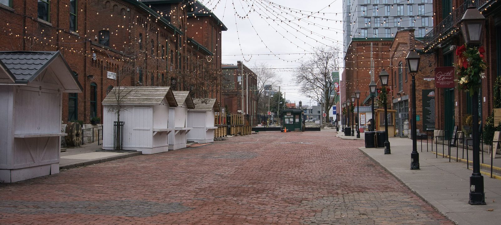
Trinity Street in the Distillery District, a brick paved lane lined with red brick Victorian industrial buildings and lamp posts
Trinity Street, in the Distillery District.
Photo: Chicken4War, CC BY-SA 4.0

About Downtown and the waterfront

Downtown is where Toronto began. The Town of York was laid out near the mouth of the Don in 1793, and the old town grew west along the harbour into what is now the Financial District. Today the core runs roughly from the lake up to Bloor Street, between Bathurst Street and the Don Valley, and it holds the office towers, the theatres, the universities, the big hospitals, and a large share of the city’s condos.

Living downtown usually means a condo, a loft in a converted warehouse, or, on the older side streets, a Victorian row house. Almost everything is within walking distance or a short ride on the subway or a streetcar, and Union Station puts GO trains, VIA Rail, and the UP Express to Pearson within reach.

Schools. Downtown has fewer schools than the residential neighbourhoods around it. Public schools are run by the Toronto District School Board, Catholic schools by the Toronto Catholic District School Board, and there are French language schools from Conseil scolaire Viamonde and MonAvenir. Catchments change as new towers fill, so it is worth checking an address with the board before you count on a school.

Bay Street and King Street

The Financial District

The Financial District is the business heart of the city, centred on King Street and Bay Street. It was first planned in 1796 as New Town, an extension of the Town of York, and it is now the main financial district in Canada. The big bank towers stand here, along with the law and accounting firms and corporate head offices that cluster around them.

Under the streets, the PATH links the towers in a long chain of underground walkways lined with shops and food courts. It is busy through the working day and much quieter in the evenings and on weekends.

Homes

Most of the district is offices, and the homes here are condos in towers along its edges, toward Yonge Street, Front Street, and the St. Lawrence area. Some of the newer buildings connect to the PATH, which is a real comfort in January.

Streets and landmarks

Union Station on Front Street is the city’s main transit hub. Old City Hall and Nathan Phillips Square, with the curved towers of City Hall behind it, are at Queen Street West and Bay Street.

Parks and green space

Green space is small and scattered: Cloud Gardens, a quiet conservatory and garden off Bay Street, and Nathan Phillips Square, which turns into a skating rink in winter.

Getting around

Line 1 runs right through it, with King, Queen, St. Andrew, Osgoode, and Union stations. Union has GO trains on every line, VIA Rail, and the UP Express to Pearson, and the King and Queen streetcars cross the district.

Day to day

The PATH links the towers to Union Station, so the office, the UP Express to the airport, and GO and VIA trains are all a short walk from home. Evenings and weekends are quieter once the offices close.

On the City’s neighbourhood map: Yonge-Bay Corridor.

King Street West, University Avenue to Spadina Avenue

The Entertainment District

The Entertainment District sits around King Street West between University Avenue and Spadina Avenue. In the first half of the 20th century it was the Garment District, almost wholly industrial, and much of it was rebuilt after the great fire of 1904. The Royal Alexandra Theatre opened on King Street West in 1907, and Ed Mirvish’s purchase of it in the 1960s started the change into the theatre and restaurant district it is today.

Roy Thomson Hall, the Princess of Wales Theatre, and the TIFF Lightbox, home of the Toronto International Film Festival, are all along King Street West. South of Front Street, the CN Tower and the Rogers Centre, where the Blue Jays play, mark the skyline.

Homes

Condo towers have filled many of the old parking lots, and a number of warehouses have been converted to lofts. Units range from compact studios close to the action to larger suites higher up with lake views.

Streets and landmarks

King Street West is the main street, with the theatres and restaurants on both sides. Front Street has the Metro Toronto Convention Centre and Roy Thomson Hall’s neighbour, the CBC Broadcasting Centre.

Parks and green space

Clarence Square and Victoria Memorial Square are small Victorian squares on the west side of the district, and the waterfront parks are a short walk south.

Getting around

St. Andrew and Osgoode stations on Line 1 are at the east edge, the 504 King streetcar runs along King Street, and Union Station is a short walk away.

Day to day

The theatres, Roy Thomson Hall, the Rogers Centre, and King Street’s restaurants are all within walking distance, and the streets stay busy late. The lake and the Martin Goodman Trail are a few blocks south.

On the City’s neighbourhood map: Wellington Place.

West of Spadina Avenue, to Dufferin Street

King West and Liberty Village

West of Spadina Avenue, King Street West changes from theatres to restaurants, bars, and design offices in old brick factories. Farther west, past Strachan Avenue, Liberty Village fills the land between King Street West and the Gardiner Expressway, out to Dufferin Street.

Liberty Village was cut off by railway lines in the 1850s, and instead of houses it got institutions and industry. The Toronto Central Prison opened here in 1873, and John Inglis and Company started building heavy machinery in 1884. The factories closed through the late 20th century, and since the early 2000s the area has filled with condos, converted lofts, offices, and shops. The Liberty Village Business Improvement Area was founded in 2001.

Homes

Mostly condos, many of them built since 2004, plus hard lofts in old factory buildings, among them the former Irwin Toy factory. There are some stacked and row townhouses as well. In King West, between Spadina and Bathurst, a few blocks of older houses survive behind the main street.

Streets and landmarks

The Toronto Carpet Factory complex on Liberty Street is a good example of the turn of the century industrial buildings that give the area its look. Lamport Stadium stands on the site of the old Andrew Mercer Reformatory, and Exhibition Place and BMO Field are just across the tracks.

Parks and green space

Liberty Village Park is the neighbourhood’s own green, and Stanley Park, Trinity Bellwoods Park, and the waterfront trail are all close.

Getting around

The 504 King streetcar runs along King Street West, and Exhibition GO station, on the Lakeshore West line, is at the south edge of Liberty Village. The roads in and out can be crowded at rush hour, which is worth knowing if you drive.

Day to day

Most errands are a short walk, with coffee, groceries, and gyms on the ground floors of the condos, and Liberty Village Park and Stanley Park for green space. The King streetcar and Exhibition GO take you downtown or out of town.

On the City’s neighbourhood map: Wellington Place, Fort York-Liberty Village. A smaller local name here is the Fashion District.

Old Town, east of Yonge Street

St. Lawrence, the Distillery, and Corktown

The oldest part of the city sits east of Yonge Street. St. Lawrence Market has been a public market since a proclamation in 1803, and Toronto’s first city hall stood at the corner of King Street East and Jarvis Street. St. Lawrence Hall and the narrow Gooderham Building, the Flatiron, built in 1892 where Wellington Street meets Front Street, are two of the landmarks.

In the 1970s, under Mayor David Crombie, the old rail and industrial land south of Front Street was rebuilt as a planned neighbourhood of co-ops, rental buildings, and condos around the Esplanade. Farther east, the Distillery District fills the old Gooderham and Worts distillery, founded in 1832. Its more than forty buildings are the largest collection of Victorian industrial architecture in North America, and it has been a National Historic Site since 1988. The district reopened as a car free area of shops, galleries, and restaurants in 2003.

Corktown, north of the Distillery, was named for the Irish immigrants who settled here, many said to be from County Cork, and worked in the local breweries and brickyards. Little Trinity Anglican Church, begun in 1843, is the city’s oldest surviving church building, and the Enoch Turner Schoolhouse of 1848 was Toronto’s first free school.

Homes

A real mix: the 1970s co-ops and townhouses of the St. Lawrence neighbourhood, condo towers along Front Street and the Esplanade, lofts in old warehouses, and late 19th century row houses and workers’ cottages on Corktown side streets such as Bright Street and Trinity Street. New condos are still going up around the Distillery.

Streets and landmarks

Front Street East has the market and the Flatiron, the Esplanade is lined with restaurants and cafés, and King Street East has St. James Cathedral. St. Paul’s Basilica is at Queen Street East and Power Street.

Parks and green space

David Crombie Park runs along the Esplanade, Berczy Park has its dog fountain, and St. James Park sits beside the cathedral.

Getting around

King and Union stations on Line 1 are at the west side, the 504 King streetcar runs along King Street East, and the Distillery Loop serves the streetcars at the east end. The Don Valley Parkway and the Gardiner are close.

Schools

St. Paul Catholic School, on Sackville Street behind St. Paul’s Basilica, traces its classes back to 1842, which makes it one of the oldest Catholic schools in Ontario.

Day to day

St. Lawrence Market is the local grocery run, busiest on Saturdays. The Esplanade and David Crombie Park are close, the Distillery District is a short walk east, and the older streets are quieter than the towers to the west.

On the City’s neighbourhood map: St Lawrence-East Bayfront-The Islands, Moss Park.
Queens Quay and the Railway Lands

The waterfront, CityPlace, and Fort York

Much of the waterfront was built on water lots filled in during the early 1900s for the port. When shipping moved away, the federal government announced the Harbourfront project in 1972 to turn the old port lands between York Street and Bathurst Street into a cultural and residential district. Harbourfront Centre, on Queens Quay West, now runs a busy year of festivals, concerts, and skating.

North of the Gardiner, CityPlace was built on the former Railway Lands, the old Canadian National rail yards west of the Rogers Centre. It is one of the largest residential developments in the city’s history, almost all of it condo towers. Next door is Fort York, a fort since 1793 and a National Historic Site, with new towers rising around its grounds. The Bentway, a public space under the Gardiner Expressway, links them.

Homes

Nearly all condos, from older buildings on Queens Quay West to the dense towers of CityPlace and the newer ones around Fort York, with some townhouses at the base of the buildings. Many have lake or skyline views. Fees and building age vary a lot, so the status certificate is one of the first things we read with you.

Streets and landmarks

Queens Quay runs along the water with a wide promenade, the Martin Goodman Trail, and the streetcar. The Rogers Centre and the CN Tower are at the east end of CityPlace, and Billy Bishop Toronto City Airport is just offshore at the foot of Bathurst Street.

Parks and green space

Canoe Landing Park in CityPlace, designed with the artist Douglas Coupland, the Toronto Music Garden, HTO Park with its sand and umbrellas, and Sugar Beach farther east.

Getting around

The 509 Harbourfront and 510 Spadina streetcars run along Queens Quay from Union Station. Union is a short walk from the east end, and Exhibition GO is at the west.

Schools

CityPlace has a public and a Catholic elementary school in a shared building beside Canoe Landing Park. Beyond that, schools are thin on the ground in the core.

Day to day

The Martin Goodman Trail, the boardwalks, Sugar Beach, and the island ferries are all close, and Union Station is a short walk north.

On the City’s neighbourhood map: Harbourfront-CityPlace, Fort York-Liberty Village. A smaller local name here is South Core.

Across the harbour

The Toronto Islands

The Toronto Islands are a chain of 15 small islands just offshore from downtown. They were a peninsula until a storm in 1858 cut the channel that made them an island for good. Today they hold Toronto Island Park, Centreville Amusement Park, beaches at Hanlan’s Point, Centre Island, and Ward’s Island, the Gibraltar Point Lighthouse of 1809, and Billy Bishop Toronto City Airport at the west end.

On Ward’s and Algonquin Islands there is a year round residential community, the largest urban car free community in North America. The homes there survived the demolitions of the mid 20th century after a long campaign by the islanders.

Homes

Island homes are mostly small cottages and houses, and they do not trade the way homes on the mainland do. The land is leased, and homes can only be sold through the Toronto Islands Residential Community Trust Corporation, to people on its Purchasers’ List, at a price set by a formula rather than by bidding.

Parks and green space

Almost the whole of the islands is parkland, with beaches, picnic areas, boardwalks, lagoons for paddling, and the gardens at Centre Island.

Getting around

Public ferries run all year from the Jack Layton Ferry Terminal at the foot of Bay Street, and water taxis run in the warmer months. There are no private cars, so islanders get around on foot and by bicycle.

Schools

The Island Public/Natural Science School is on Centre Island. For high school, students cross to the mainland.

Day to day

There are no private cars, so residents get around by bike and by ferry. Few homes come up for sale, and for most people the islands are a day trip.

On the City’s neighbourhood map: St Lawrence-East Bayfront-The Islands.

The Village

Church and Wellesley

Church and Wellesley, often just called the Village, is the centre of Toronto’s LGBTQ community. Its main strip runs along Church Street, south from Wellesley Street, and Pride Toronto, the largest event of its kind in Canada, fills the streets every June.

The centre of gay life in the city moved here after the bathhouse raids of 1981 galvanized the community. Behind the shops, it is also an old residential neighbourhood, with Victorian houses and apartments from the late 19th and early 20th centuries.

Homes

Victorian houses, many divided into flats, sit beside older rental apartment towers and newer condos, especially toward Yonge Street and Bloor Street.

Streets and landmarks

Church Street has the bars, restaurants, and shops, and The 519, the community centre, is on Church Street beside Barbara Hall Park.

Parks and green space

Barbara Hall Park, Cawthra Square, and the AIDS Memorial are together behind The 519, and Allan Gardens is a short walk southeast.

Getting around

Wellesley and College stations on Line 1 are a block west, and Bloor-Yonge, where Lines 1 and 2 meet, is close to the north end. The 506 Carlton streetcar runs along Carlton Street and College Street.

Day to day

Pride fills the streets in June and the Church Street patios are busy all summer. The subway at Wellesley and College is a few blocks away, and Cawthra Square is the local park.

On the City’s neighbourhood map: Church-Wellesley.

Bay Street, Queen’s Park, and the hospitals

The Bay Street Corridor and the Discovery District

North of the Financial District, Bay Street turns into a long corridor of condo towers running up toward Bloor Street. To the west, the Discovery District holds the main research hospitals along University Avenue, among them the Hospital for Sick Children, Toronto General Hospital, Princess Margaret Cancer Centre, and Mount Sinai Hospital, alongside the University of Toronto’s St. George campus.

Queen’s Park, with the Ontario Legislative Building, sits at the top of University Avenue, and the Royal Ontario Museum is at Bloor Street and Queen’s Park.

Homes

Almost all condos, from older buildings of the 1970s and 1980s to new towers, with a wide range of unit sizes. Many residents walk to class, to the hospitals, or to the office.

Streets and landmarks

Bay Street is the main residential corridor, University Avenue is lined with hospitals, and College Park, the old Eaton’s College Street store, is at Yonge Street and College Street.

Parks and green space

Queen’s Park is the big green space, and College Park has a pond that becomes a skating rink in winter.

Getting around

Line 1 runs on both sides: Queen’s Park, St. Patrick, and Museum stations under University Avenue, and College and Wellesley under Yonge Street. Bay and St. George stations on Line 2 are at the north end.

Day to day

Everything is close: the universities, the hospitals on University Avenue, the Eaton Centre, and the subway lines underneath. Many residents walk to class or work and hardly need a car.

On the City’s neighbourhood map: Bay-Cloverhill, Yonge-Bay Corridor, University.

Yonge Street east to Sherbourne Street

The Garden District and Moss Park

The Garden District takes its name from Allan Gardens, the indoor botanical garden at Carlton Street and Jarvis Street. The name was chosen by the local residents’ association and made official by City Council in 2001. The district runs from Yonge Street east to Sherbourne Street, between Carlton Street and Queen Street, and takes in the southern part of the Village, Toronto Metropolitan University, and the Mackenzie House museum.

Moss Park, to the southeast, was named for the estate of the Allan family, whose mansion stood on Sherbourne Street. Much of it was rebuilt in the 1960s, including the public housing towers at Queen Street East and Parliament Street.

Homes

A wide mix: renovated Victorian villas and Edwardian row houses on the side streets east of Jarvis, apartment co-ops, subsidized housing, older rental towers, and new condos along Yonge Street and Jarvis Street.

Streets and landmarks

Jarvis Street was once one of the grandest streets in the city, and some of its mansions still stand. Yonge Street has the Eaton Centre and Massey Hall at the west edge, and Toronto Metropolitan University’s campus fills the blocks around Gould Street.

Parks and green space

Allan Gardens, with its Palm House and greenhouses, and Moss Park, with its sports fields and the Moss Park Armoury beside it.

Getting around

TMU, Queen, and College stations on Line 1 are along Yonge Street, and the 505 Dundas and 506 Carlton streetcars cross the district.

Day to day

Allan Gardens and its greenhouses are the local park, TMU and the Eaton Centre are a short walk west, and the side streets still have Victorian houses among the newer buildings.

On the City’s neighbourhood map: Downtown Yonge East, Moss Park.