South Huron · Huron County

Exeter

A Huron County market town on Highway 4 and the Ausable River, with a hospital, a long Main Street, and a famous population of white squirrels.

8 minute read

Map of Exeter: every one of the County urban area is shaded by the part of Exeter it belongs to in our guide, with the rivers, main roads, and parks. Choose one to open it in our guide.Main StreetMacNaughtonParkNorth endEast sideSouth end
Huron County open data and OpenStreetMap
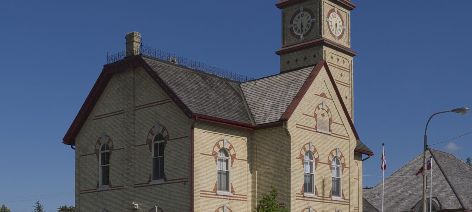
Exeter’s yellow brick town hall with its clock tower, on Main Street
Exeter’s town hall, built in 1887.
Photo: JustSomePics, CC BY-SA 4.0

About Exeter

Exeter is the largest community in the Municipality of South Huron, in the southern tip of Huron County, about 45 minutes north of London on Highway 4. Main Street is the highway, and the Ausable River winds through the north end of town.

For most of its history it has been the service and market centre for some of the most productive farmland in Canada, and it still has the things a town needs: a hospital, schools from kindergarten through high school, an arena, and a long Main Street of local businesses. Grand Bend and the Lake Huron shore are about 25 minutes west.

Below you’ll find the town’s story, the river trails, the white squirrels, the schools, and how people get around, then a walk through Exeter itself: Main Street, the river and the north end, and the newer streets to the east and south.

Exeter in depth

Francistown, Exeter, and the town hall

Exeter grew out of the Huron Tract, the land the Canada Company opened for settlement in the 1820s. James Willis and William McConnell and their families were the first settlers here in the early 1830s, and McConnell soon built mills on the Ausable, where a settlement called Francistown grew up. South of it, near Willis’s land on the London Road, Isaac Carling opened a store and tannery in 1847, and many of the families who followed came from Devon in England, so the village laid out in the 1850s took the name Exeter.

Expecting the railway, Exeter and Francistown joined as the Village of Exeter in 1873, and the London, Huron and Bruce Railway arrived a few years later. The town hall on Main Street was built in 1887, the year of Queen Victoria’s Golden Jubilee, and local people later saved it from demolition; it was restored and serves the municipality again. Exeter became a town in 1951 and joined the townships of Stephen and Usborne as the Municipality of South Huron in 2001.

Street names such as Willis Way, McConnell Street, Carling Street, and Pickard Road share their names with the first settlers and storekeepers.

Exeter in depth

The white squirrels

Exeter calls itself the Home of the White Squirrel. They aren’t albinos but a rare white form of the grey squirrel. The town’s mascot, Willis the White Wonder, turns up at Canada Day, the Exeter Rodeo, and the Santa Claus Parade.

Exeter in depth

The Ausable River, MacNaughton Park, and Morrison Dam

The Ausable River runs through the north end of town, and MacNaughton Park, at the end of Hill Street, is the Exeter end of the MacNaughton Morrison Trail. The trail follows the river valley east to the Morrison Dam Conservation Area, run by the Ausable Bayfield Conservation Authority; the dam there was completed in 1959.

The South Huron Recreation Centre is home to the Exeter Hawks junior hockey team and to public skating through the winter.

Exeter in depth

Schools, the library, and the hospital

Children can go from kindergarten through Grade 12 in Exeter. Public schools are run by the Avon Maitland District School Board: Exeter Elementary School on Victoria Street East, and South Huron District High School on Gidley Street East, which has been the high school for southern Huron County since 1949 and now also takes Grade 7 and 8 students. Precious Blood Catholic School, on Sanders Street West, is run by the Huron-Perth Catholic District School Board. There is no Catholic high school in town. Boundaries change, so it is worth checking an address with the board before you buy.

The Huron County Library’s Exeter branch is at 330 Main Street South, beside the town hall, and South Huron Hospital is on Huron Street West.

Exeter in depth

Getting around

Almost everyone drives. Highway 4 runs straight down to London, about 45 minutes away, with Lucan on the way, and at the north end of town it meets County Road 83, the busiest intersection in Huron County and the road most people take west to Grand Bend and Lake Huron. Hensall is just up Highway 4.

Along Highway 4

Main Street and the old town

The old town lines Main Street, from the town hall and the library south of the river to the older brick streets on either side.

Map of Main Street and the old town in Exeter: the County urban area in this part are shaded, with the rivers, main roads, and parks. Each place in our guide is marked; choose one to read about it.Main Street
Huron County open data and OpenStreetMap

The centre of town

Main Street and the town hall

Main Street is Highway 4, and most of Exeter’s shops and restaurants are along it. The town hall of 1887 stands at the corner of Main and Sanders streets, with the library beside it, and South Huron Hospital is close by on Huron Street West.

Homes

Older brick homes near Main Street, some from the late 1800s, on mature, tree lined lots.

Streets and landmarks

Main Street South, Sanders Street, Huron Street, and Carling Street.

Schools

Precious Blood Catholic School, on Sanders Street West.

On the County’s urban area map: Exeter urban area.

Old Francistown

The river and the north end

North of Wellington Street, the town drops to the Ausable, where Francistown once stood, and climbs again toward Thames Road and County Road 83.

Map of The river and the north end in Exeter: the County urban area in this part are shaded, with the rivers, main roads, and parks. Each place in our guide is marked; choose one to read about it.MacNaughton ParkNorth end
Huron County open data and OpenStreetMap

Where Francistown stood

The Ausable and MacNaughton Park

North of downtown, Main Street crosses the Ausable, where McConnell’s mills and the settlement of Francistown once stood. A plaque on the founding of Exeter is in a small park on the east side of Main Street North, just south of the bridge, and MacNaughton Park, at the end of Hill Street, starts the trail east along the river.

Homes

Homes of different ages on the streets near the river.

Streets and landmarks

Main Street North, Hill Street, MacNaughton Drive, and Riverside Drive.

Parks and green space

MacNaughton Park and the MacNaughton Morrison Trail.

On the County’s urban area map: Exeter urban area.

Toward Thames Road

North of the river

Across the river, the north end runs up to Thames Road and the junction of Highway 4 and County Road 83. Riverview Estates and Riverview Meadows, communities for adults and retirees, are off Kalisch Avenue.

Homes

Family homes and adult lifestyle communities.

Streets and landmarks

Kalisch Avenue, Devon Drive, Alexander Street, and Thames Road.

Getting around

County Road 83 leads west to Grand Bend.

On the County’s urban area map: Exeter urban area.

The schools and the newer streets

The east side and the south end

East of Main Street are the schools and the arena, with newer subdivisions beyond them, and the south end has newer streets of its own.

Map of The east side and the south end in Exeter: the County urban area in this part are shaded, with the rivers, main roads, and parks. Each place in our guide is marked; choose one to read about it.East sideSouth end
Huron County open data and OpenStreetMap

The schools, the arena, and Windermere

Gidley Street and the east side

East of Main Street, Exeter Elementary School and South Huron District High School share neighbouring sites on Victoria Street East and Gidley Street East, and the South Huron Recreation Centre is close by. Further east, the Windermere subdivision, around Pryde Boulevard, Kingscourt Crescent, and Eastern Avenue, is planned for about 243 homes.

Homes

Postwar bungalows and side splits, with newer homes toward the east edge.

Streets and landmarks

Gidley Street, Victoria Street, Pryde Boulevard, and Eastern Avenue.

Schools

Exeter Elementary School and South Huron District High School.

On the County’s urban area map: Exeter urban area.

South of Huron Street

The south end

South of Huron Street, the streets run toward the south edge of town. The South Pointe subdivision, on Rowe, Lawson, and Albert streets, is one of the newer additions here.

Homes

Newer bungalows, two storey homes, and townhouses, with some older houses closer to Huron Street.

Streets and landmarks

Albert Street, Simcoe Street, and Jessica Avenue.

Getting around

Highway 4 leads south toward Lucan and London.

On the County’s urban area map: Exeter urban area.

Sources

Written from our work with clients here and the time we have spent getting to know the town, and checked against the sources below.

Each fact was checked against at least two sources. Neighbourhood names follow local usage, and the official areas each entry covers are listed under it. The streets named are examples rather than boundaries. Details such as school boundaries, zoning, and bus routes change, so please check anything important with the municipality, the transit agency, or the school board.