Perth County

Stratford

A small city built around the Avon River and its parks, with four Festival theatres and a historic downtown.

10 minute read

Map of Stratford: every one of the city boundary is shaded by the part of Stratford it belongs to in our guide, with the rivers, main roads, and parks. Choose one to open it in our guide.DowntownLakesideDriveDevon StreetRomeo NorthDufferin ParkJohn StreetSouthWest edgeNorthwest
OpenStreetMap contributors
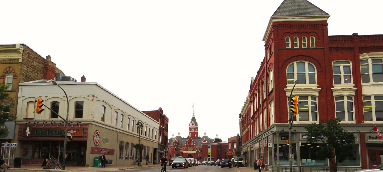
Stratford City Hall, a red brick building with a clock tower, beside the Gordon Block downtown
City Hall and the Gordon Block, Stratford.
Photo: Ken Lund from Reno, Nevada, USA, CC BY-SA 2.0

About Stratford

Stratford is a city of about 33,000 in Perth County, west of Kitchener on Highways 7 and 8. The Canada Company settled it in 1832 and named it for Stratford-upon-Avon, and the river through town became the Avon. It grew up as a railway town, and for many years the Grand Trunk locomotive repair shops were its biggest employer.

In 1953 the Stratford Festival staged its first season in a tent by the river. It now plays in four theatres from spring into fall, and the parks along the Avon, the downtown, and much of the city’s life have grown up around it.

Below you’ll find the Festival and the river parks, the schools, the hospital, and how people get around, including the new GO train, then a walk through the city: downtown and the river, the east end, the south end, and the west side. Most of Stratford’s neighbourhoods don’t have official names, so ours follow the main streets and local usage.

Stratford in depth

The Festival and its four theatres

The Stratford Festival began in 1953 with a season in a tent beside the Avon. The Festival Theatre, on Queen Street, opened in 1957, and the Festival now plays across four stages: the Festival and the Tom Patterson in the parkland by the river, and the Avon Theatre on Downie Street and the Studio Theatre on George Street East, downtown.

The Festival sets the rhythm of the year here. From spring into fall, theatregoers fill the restaurants and shops downtown.

Stratford in depth

The Avon River and the parks

The Avon runs through the middle of the city, widening into Lake Victoria, and the city keeps the land along its banks as parkland: about 115 acres of formal parks, with Upper Queen’s Park and the bandshell where the Stratford Concert Band plays free outdoor concerts in summer. Swans have lived on the river since a pair arrived as a gift in 1918, and the city releases them back onto the water every spring.

Away from the river, the Avon Trail runs through the T.J. Dolan Natural Area on the west side and continues out into the country.

Stratford in depth

Shakespeare on the street signs

You’ll find Shakespeare all over the map. The old wards were Avon, Falstaff, Hamlet, Romeo, and Shakespeare, and the public schools include Anne Hathaway, Hamlet, Romeo, and Shakespeare. Romeo Street, Falstaff Street, and Portia Boulevard are on the map too.

Stratford in depth

Schools, the college campuses, and the hospital

Public schools are run by the Avon Maitland District School Board: Anne Hathaway, Avon, Bedford, Hamlet, Romeo, and Shakespeare public schools, Stratford Intermediate School, and Stratford District Secondary School on Forman Avenue. Catholic schools are run by the Huron-Perth Catholic District School Board: Jeanne Sauvé, St. Aloysius, St. Ambrose, and St. Joseph, with St. Michael Catholic Secondary School on Oakdale Avenue. Boundaries change, so it is worth checking an address with the board before you buy.

The University of Waterloo’s Stratford School opened its campus in 2010, and the Stratford Chef School trains cooks here. Stratford General Hospital is on the west side of the city.

Stratford in depth

Getting around

Highway 7 and Highway 8 meet in Stratford: Erie Street brings Highway 7 in from the south, Huron Street brings Highway 8 in from the west, and Ontario Street carries both east toward Kitchener. Stratford Transit runs the city buses.

The station on Shakespeare Street has VIA Rail trains on the line between Toronto and Sarnia, and since July 6, 2026, GO Transit has run one train each way every day on an extension of the Kitchener line to Union Station.

Market Square, the theatres, and the parks

Downtown and the river

Downtown sits just south of the Avon around City Hall and Market Square, and the river parks curve along the water to the north and east, past the Festival Theatre.

Map of Downtown and the river in Stratford: the city boundary in this part are shaded, with the rivers, main roads, and parks. Each place in our guide is marked; choose one to read about it.DowntownLakeside Drive
OpenStreetMap contributors

The heritage core

Downtown and Market Square

Downtown is the heritage core around City Hall and Market Square. City Hall opened in 1900 and was named a National Historic Site in 1976. The Avon Theatre is on Downie Street and the Studio Theatre on George Street East, with independent shops and restaurants at street level, and the library is on St. Andrew Street.

Homes

Some of the city’s oldest housing, including Victorian brick homes on streets such as Waterloo, Albert, and Ontario.

Streets and landmarks

Ontario, Downie, Wellington, Waterloo, and Albert streets.

Schools

Romeo Public School, Jeanne Sauvé Catholic School, and Stratford Intermediate School are close by.

Day to day

The most walkable part of the city, with the river parks a few minutes away.

On the city map: City of Stratford.

Along the Avon

Lakeside Drive and the river

The parkland along the Avon runs from downtown past the Tom Patterson Theatre and Tom Patterson Island to the Festival Theatre and Upper Queen’s Park. The homes facing it, along Lakeside Drive and, on the north shore, William Street, look out over the water and the park.

Homes

Older and updated homes of many styles, with park and river views.

Streets and landmarks

Lakeside Drive, William Street, Cobourg Street, and Water Street.

Parks and green space

Upper Queen’s Park, the North Shore parkland, and Tom Patterson Island.

On the city map: City of Stratford.

Devon Street and Romeo Street North

The east end

East of downtown, Ontario Street is the main commercial strip, with established streets behind it and newer homes north toward the Stratford Country Club.

Map of The east end in Stratford: the city boundary in this part are shaded, with the rivers, main roads, and parks. Each place in our guide is marked; choose one to read about it.Devon StreetRomeo North
OpenStreetMap contributors

Behind the Ontario Street shops

Devon Street

Behind the Ontario Street commercial strip, Devon Street and the avenues around it are established streets with mature trees and postwar bungalows and raised ranches. The Ontario Street shops and grocery stores are a block or two away, and the Devon Street West parkland runs behind.

Homes

Postwar bungalows and raised ranches on good sized lots.

Streets and landmarks

Devon Street, Willow Street, and Ontario Street.

Getting around

Ontario Street leads east toward Kitchener, and city buses run nearby.

On the city map: City of Stratford.

North of the river

Romeo Street North

North of the river, along both sides of Romeo Street North beyond the Stratford Country Club, newer subdivisions of detached homes and condominium townhouses run out toward Vivian Line. Bedford Public School is on Bedford Drive.

Homes

Newer detached homes and condominium townhouses.

Streets and landmarks

Romeo Street North, Bedford Drive, and Vivian Line.

Schools

Bedford Public School.

On the city map: City of Stratford.

Around Dufferin Park

The south end

South of downtown, the streets around Dufferin Park and Lorne Avenue mix homes of many ages with parks, an arena, and schools.

Map of The south end in Stratford: the city boundary in this part are shaded, with the rivers, main roads, and parks. Each place in our guide is marked; choose one to read about it.Dufferin Park
OpenStreetMap contributors

Under the old water tower

Dufferin Park and the south end

The south end spreads around Dufferin Park, from Dufferin Street toward Downie Street, with mature trees and houses of many ages. The Dufferin arena is here, Lorne Avenue runs along the south with shops and industry, and Shakespeare Public School, St. Ambrose Catholic School, and Anne Hathaway Public School are close by.

Homes

Houses of many ages on tree lined streets.

Streets and landmarks

Dufferin Street, Downie Street, Lorne Avenue, and Mowat Street.

Parks and green space

Dufferin Park.

Getting around

Highway 7 is close by on Erie Street.

On the city map: City of Stratford.

From the hospital to the newest streets

The west side

West of downtown, the city runs past the hospital and the T.J. Dolan Natural Area to newer subdivisions at the northwest and west edges, near the high schools and the Rotary Complex.

Map of The west side in Stratford: the city boundary in this part are shaded, with the rivers, main roads, and parks. Each place in our guide is marked; choose one to read about it.John Street SouthWest edgeNorthwest
OpenStreetMap contributors

By the hospital

John Street South

Along John Street South, near the hospital and the river in the southwest of the city, heritage homes sit on large, treed lots, and the streets beyond are younger, with curved roads and crescents. Stratford General Hospital is next door, and Avon Public School and Hamlet Public School are nearby.

Homes

Heritage homes on John Street South, with younger houses on the crescents beyond.

Parks and green space

The Avon Trail and the T.J. Dolan Natural Area are close.

Schools

Avon Public School, Hamlet Public School, and St. Joseph Catholic School.

On the city map: City of Stratford.

Avon West, Sir Adam Beck Road, and Poet & Perth

The west edge

On the west edge, around O’Loane Avenue between Huron Street and Lorne Avenue West, newer subdivisions back onto countryside and forest, among them Avon West and the streets off Sir Adam Beck Road beside the T.J. Dolan Natural Area. Further out, Poet & Perth is a newer community of bungalows near Perth Line 36.

Homes

Newer detached homes, townhouses, and bungalows.

Streets and landmarks

O’Loane Avenue, Sir Adam Beck Road, and Huron Street.

Parks and green space

The T.J. Dolan Natural Area.

On the city map: City of Stratford.

The northwest

Forman Avenue and McCarthy Road

In the northwest, the two high schools sit side by side: Stratford District Secondary School on Forman Avenue and St. Michael Catholic Secondary School on Oakdale Avenue. The Rotary Complex is close by, with the Saturday farmers’ market, and newer streets around Forman Avenue and McCarthy Road, including the Knightsbridge subdivision, are still being built out.

Homes

Newer detached homes and townhouses.

Streets and landmarks

Forman Avenue, McCarthy Road, and Oakdale Avenue.

Schools

Stratford District Secondary School, St. Michael Catholic Secondary School, Avon Public School, and St. Aloysius Catholic School.

On the city map: City of Stratford.

Sources

Written from our work with clients here and the time we have spent getting to know the city, and checked against the sources below.

Each fact was checked against at least two sources. Neighbourhood names follow local usage, and the official areas each entry covers are listed under it. The streets named are examples rather than boundaries. Details such as school boundaries, zoning, and bus routes change, so please check anything important with the municipality, the transit agency, or the school board.