North Dumfries · Waterloo Region

Ayr

A nineteenth century mill village on the Nith River, with a historic main street at its centre and newer family streets around it.

8 minute read

Map of Ayr: every one of the Region settlement areas is shaded by the part of Ayr it belongs to in our guide, with the rivers, main roads, and parks. Choose one to open it in our guide.DowntownHall StreetHilltopPiper’s GlenGreenfieldNorth tothe 401
Region of Waterloo Open Data and OpenStreetMap
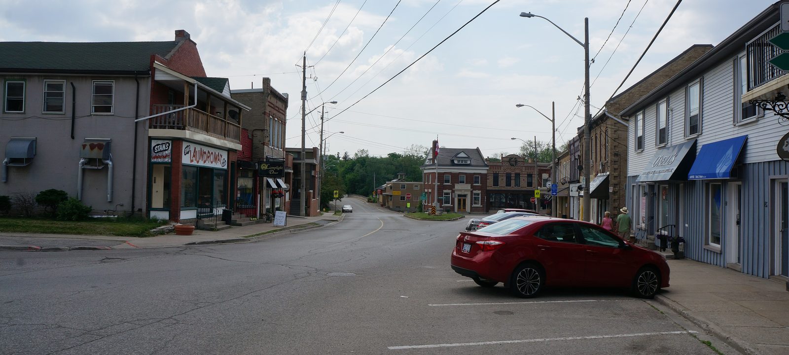
Older brick storefronts on a main street in Ayr, Ontario
Downtown Ayr.
Photo: Jfvoll, CC BY-SA 4.0

About Ayr

Ayr is the main village of North Dumfries Township, in Waterloo Region, south of Kitchener and west of Cambridge. It sits where Cedar Creek meets the Nith River, and about 5,400 people lived here at the 2021 census.

It began in 1824 as Mudge’s Mills, around Abel Mudge’s sawmill and grist mill, with Jedburgh to the east and Nithvale to the west. Over the next sixty years the three grew into one village, and the name Ayr, which came with the post office, is the one that stuck.

Below you’ll find the village’s story, the pond and the parks, the schools, and how people get around, then a walk through Ayr itself: the old village, the newer streets on either side, and the settlement areas at the edges.

Ayr in depth

Three mill settlements and a foundry

Abel Mudge dammed Cedar Creek where it enters the Nith in 1824, and Mudge’s Mills grew around his sawmill and grist mill. Two years later a road was built north to Roseville; it is Northumberland Street today. John Hall, from Scotland, founded Jedburgh to the east in 1832, and Nithvale grew to the west in the 1830s. Most of the early settlers were Scottish.

In the 1840s John Watson opened a foundry by the Nith that made iron pots and stoves and later mowers, reapers, and other farm machinery. In 1868 he bought the old Mudge property and built the dam that still holds Watson’s Pond. The Credit Valley Railway reached Ayr in 1879, and when the village was incorporated in 1884, Watson became its first reeve.

Growth slowed after 1900, and from the 1950s on Ayr began adding homes for people working in Cambridge, Kitchener, and beyond. Much of the nineteenth century village survives along Stanley, Swan, and Northumberland streets.

Ayr in depth

Watson’s Pond, the parks, and the community complex

Watson’s Dam stands where Cedar Creek enters the Nith, on Northumberland Street just north of Stanley Street. In 1965 the Watson company handed its water rights to the Grand River Conservation Authority and the village, and the pond became a park. Today it’s the village’s spot by the water, and the marker beside the dam explains its part in the Grand being named a Canadian Heritage River.

Victoria Park, on Rose Street just beyond the downtown, has two ball diamonds used by Ayr Minor Softball. Jim Schmidt Memorial Park, on Hilltop Drive, opened in 1999, and Piper’s Glen, on Nith River Way, and Douglas Park are on the northwest side.

The North Dumfries Community Complex, at 2958 Greenfield Road, opened in 2011 and holds the Ayr Farmers Mutual Arena, where the Ayr Centennials play junior hockey. The Ayr Curling Club is on Northumberland Street.

Ayr in depth

Schools and the library

Ayr has three elementary schools. Ayr Public School, on Hall Street, dates from 1890 and was the village’s only school for nearly a century. Cedar Creek Public School, on Hilltop Drive, opened in 1999, and St. Brigid Catholic Elementary School, on Broom Street, opened in 1998. The public schools are run by the Waterloo Region District School Board and the Catholic school by the Waterloo Catholic District School Board.

There is no high school in Ayr, so students go into Cambridge. Boundaries change, so it is worth checking an address with the board before you buy. The Region of Waterloo Library’s Ayr branch is at 137 Stanley Street.

Ayr in depth

Ayr on screen

The old main street has had its turn on screen. In June 2015, the Queen’s Tavern was dressed as a 1950s bar for 11.22.63, the Stephen King miniseries starring James Franco.

Ayr in depth

Getting around

Ayr is mostly a driving village. Northumberland Street leads north to Highway 401, Cambridge is a short drive east, and Kitchener is to the north. Public transit is limited, so most people plan on a car.

By the pond and the Nith

The old village

The old village sits around Watson’s Pond and the Nith, along Stanley, Swan, Piper, and Northumberland streets, with Hall Street and the old Jedburgh lands to the northeast.

Map of The old village in Ayr: the Region settlement areas in this part are shaded, with the rivers, main roads, and parks. Each place in our guide is marked; choose one to read about it.DowntownHall Street
Region of Waterloo Open Data and OpenStreetMap

The village core

Downtown and Watson’s Pond

This is the Ayr of the 1800s. Stanley Street and Northumberland Street meet near Watson’s Dam, and many of the buildings along them, and along Swan and Piper streets, date from the nineteenth and early twentieth centuries. The library is at 137 Stanley Street, and Victoria Park is a few blocks away on Rose Street.

Homes

Older homes close to the main street and the river; with houses this age, it pays to look closely at wiring, plumbing, and foundations.

Streets and landmarks

Stanley, Northumberland, Swan, Piper, Church, and Water streets.

Parks and green space

Watson’s Pond and Victoria Park.

Day to day

Shops and restaurants on the main street, with bigger errands in Cambridge.

On the Region’s settlement map: Ayr.

Where Jedburgh stood

Hall Street and the northeast

John Hall’s Jedburgh, with its flour mill and distillery, stood on the east side of the village, and Hall Street and Jedburgh Pond keep the memory of it. Ayr Public School, built in 1890, is at 105 Hall Street.

Homes

Village homes of different ages around the school.

Streets and landmarks

Hall, Inglis, Newell, Willison, and Cooper streets.

Schools

Ayr Public School, on Hall Street.

On the Region’s settlement map: Ayr.

East on the hill and northwest by the river

The newer streets

Ayr has grown in two directions: up the hill to the east around Hilltop Drive, and northwest along the Nith around Broom Street and Nith River Way.

Map of The newer streets in Ayr: the Region settlement areas in this part are shaded, with the rivers, main roads, and parks. Each place in our guide is marked; choose one to read about it.HilltopPiper’s Glen
Region of Waterloo Open Data and OpenStreetMap

Up the hill from the village

Hilltop and the east side

East of the old village, the streets lead up to Hilltop Drive, where Cedar Creek Public School opened in 1999 and Jim Schmidt Memorial Park the same year. Beyond them, newer streets run south and east, such as Mary Watson Street, Robert Simone Way, and Henry Maracle Street.

Homes

Newer family homes on the streets around the school and the park.

Streets and landmarks

Hilltop Drive, Watson Crescent, Robert Simone Way, Mary Watson Street, and Thomas Gemmell Road.

Parks and green space

Jim Schmidt Memorial Park, with two ball diamonds.

Schools

Cedar Creek Public School, on Hilltop Drive.

On the Region’s settlement map: Ayr.

Northwest along the river

Piper’s Glen and the Nith

Northwest of downtown, along the Nith, newer streets such as Nith River Way, Ayr Meadows Crescent, and Douglas Drive surround Piper’s Glen park and Douglas Park. St. Brigid Catholic Elementary School is at 50 Broom Street.

Homes

Family homes on newer streets near the river.

Streets and landmarks

Nith River Way, Broom Street, Douglas Drive, and Ayr Meadows Crescent.

Parks and green space

Piper’s Glen and Douglas Park.

Schools

St. Brigid Catholic Elementary School, on Broom Street.

On the Region’s settlement map: Ayr.

Toward the 401

Greenfield and the north edge

West and north of the village, the Region maps H’Ayritage, Greenfield, and two small areas on the way to Highway 401.

Map of Greenfield and the north edge in Ayr: the Region settlement areas in this part are shaded, with the rivers, main roads, and parks. Each place in our guide is marked; choose one to read about it.GreenfieldNorth to the 401
Region of Waterloo Open Data and OpenStreetMap

The west edge

Greenfield and H’Ayritage

West of Ayr, the Region maps H’Ayritage, at the village’s west edge, and Greenfield, the small village founded by the botanist John Goldie and his family. Goldie Mill Road and Mudge’s Mill Lane run nearby, and Greenfield Road leads to the community complex.

Homes

A small number of homes at the edge of the village and in the country.

Getting around

Greenfield Road and Northumberland Street lead back into the village.

On the Region’s settlement map: Greenfield and H’Ayritage.

Along Northumberland Street

North toward the 401

North of Greenfield, the Region maps a small area at Regional Road 58 and Township Road 3 and a business area at Highway 401 and Township Road 2.

Homes

A few homes, mostly on the country roads.

Getting around

Highway 401 is right here.

On the Region’s settlement map: Regional Road 58 and Township Road 3 area and Highway 401 and Township Road 2 business area.

Sources

Written from our work with clients here and the time we have spent getting to know the village, and checked against the sources below.

Each fact was checked against at least two sources. Neighbourhood names follow local usage, and the official areas each entry covers are listed under it. The streets named are examples rather than boundaries. Details such as school boundaries, zoning, and bus routes change, so please check anything important with the municipality, the transit agency, or the school board.