Oxford County

Living in Woodstock

The Friendly City on the Thames, with a museum in its 1853 town hall, Southside Park, the Pittock Reservoir, and a statue of a champion cow.

8-minute read

Map of Woodstock: every one of the city boundary is shaded by the part of Woodstock it belongs to in our guide, with the rivers, main roads, and parks. Choose one to open it in our guide.DowntownVansittartNorth endEast endSouth end
OpenStreetMap contributors

Thinking of selling in Woodstock? What is my home worth? · Book a conversation

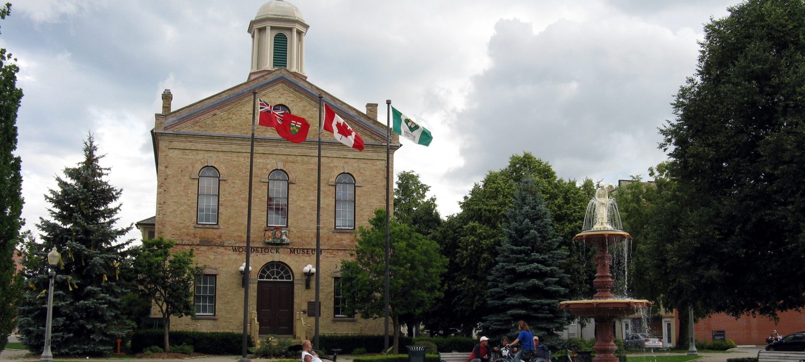
The Old Woodstock Town Hall, a yellow brick building with a cupola and flags out front, with a fountain beside it on Museum Square
The Old Town Hall on Dundas Street, now the Woodstock Museum.
Photo: Balcer, public domain

About Woodstock

Woodstock is a city of about 46,700 on the Thames River and Highway 401, and the seat of Oxford County. It began in 1800 as the Town Plot, where settlers including Zacharias Burtch and Levi Luddington took up land, and in 1834 Admiral Henry Vansittart named it after Woodstock in Oxfordshire, England. It became a town in 1851 and a city in 1901, so 2026 marks 125 years as a city.

Dairy farming shaped the county around it, and Woodstock calls itself the Dairy Capital of Canada. A statue of Springbank Snow Countess, a world champion butterfat producer, has stood on Dundas Street since 1937. It also calls itself the Friendly City. The population grew 13.6 percent between 2016 and 2021, and Toyota has built the RAV4 at its plant in the northeast end since 2008.

Below you’ll find the history, the parks and the Pittock Reservoir, the schools, the hospital, and how to get around, then a walk through the city: downtown, Vansittart Avenue and the west end, the north end, the east end, and the south end.

Woodstock in depth

The Town Plot and the Old Town Hall

Woodstock grew from the Town Plot settled in 1800, and the name came in 1834 from Admiral Henry Vansittart, after Woodstock in Oxfordshire. The town was incorporated in 1851 and became a city in 1901.

The Old Town Hall on Dundas Street at Finkle Street was built in 1853 and designated a National Historic Site in 1955. It has housed the Woodstock Museum since 1968, facing Museum Square. A short walk north, the Woodstock Public Library on Hunter Street opened in 1909 in a building paid for with a Carnegie grant.

Woodstock in depth

The Dairy Capital and the Friendly City

Oxford County is dairy country, and Woodstock calls itself the Dairy Capital of Canada. The statue of Springbank Snow Countess, a Holstein that was a world champion lifetime butterfat producer, has stood on Dundas Street at Springbank Avenue since 1937.

Industry is a big part of the city too. Toyota’s plant in the northeast end began building the RAV4 in November 2008.

Woodstock in depth

Southside Park, Pittock, and the parks

Southside Park is the largest park in Woodstock and dates to 1909. It has the Tip O’Neil ball diamond, a skate park, a bandshell, a boathouse, and a toboggan hill, and the Southside Aquatic Centre on Finkle Street is the city’s indoor pool.

North of downtown, the Upper Thames River Conservation Authority built the Pittock Dam between 1964 and 1967, and the reservoir behind it’s the centre of Pittock Conservation Area, with camping, boating, and trails, including the paved trail in Roth Park and the South Shore Trail. In the northwest, Cowan Park Sportsplex has an indoor artificial turf field and a gymnasium, with fields outside.

Woodstock in depth

Schools, the college, and the hospital

Public schools are run by the Thames Valley District School Board, with three high schools: Woodstock Collegiate Institute on Riddell Street, Huron Park Secondary School on Cromwell Street, and College Avenue Secondary School. Catholic schools are run by the London District Catholic School Board, with St. Mary’s High School on Juliana Drive, and French Catholic schools by Conseil scolaire catholique Providence, with École secondaire catholique Notre-Dame. Boundaries change, so check the address with the school boards before you buy.

Fanshawe College has a campus on Finkle Street. Woodstock Hospital moved to its building on Juliana Drive in November 2011, replacing a hospital that opened on Riddell Street in 1895.

Woodstock in depth

Getting around

Highway 401 runs along the south side of the city, and Highway 403 begins at the 401 on the southeast edge and runs east toward Brantford. VIA Rail stops at the station on Victoria Street South, just south of downtown, and Woodstock Transit runs city bus routes on weekdays and Saturdays.

Woodstock in depth

Museum Square and the Carnegie library

The Old Town Hall on Dundas Street was built in 1853, two years after Woodstock became a town, and it was designated a National Historic Site in 1955. Since 1968 it has been home to the Woodstock Museum, and it faces Museum Square.

A short walk north, at 445 Hunter Street, is the Woodstock Public Library. The city won a Carnegie grant for it in 1905, and the building opened in 1909. It is still the city’s public library.

Woodstock in depth

Vansittart Avenue and Carbide Willson

Vansittart Avenue is lined with Victorian homes. Among them is 210 Vansittart, a Queen Anne Revival house built in 1895 by the inventor Thomas “Carbide” Willson. The city designated it under the Ontario Heritage Act in 1977, and it has since been a guest house, Château la Motte.

Woodstock in depth

Pittock, on the Thames

The Upper Thames River Conservation Authority began the Pittock Dam in 1964 and finished it in 1967 for flood control on the Thames. The reservoir behind it reaches into the north end of the city.

Around the water, Pittock Conservation Area has camping, boating, and trails, Roth Park has a paved trail, and the South Shore Trail is free to use.

Dundas Street and Museum Square

Downtown

Downtown sits along Dundas Street, with the Old Town Hall, Museum Square, the library, and the train station a few blocks south.

Map of Downtown in Woodstock: the city boundary in this part are shaded, with the rivers, main roads, and parks. Each place in our guide is marked; choose one to read about it.Downtown
OpenStreetMap contributors

The Old Town Hall and Museum Square

Downtown and Dundas Street

Downtown runs along Dundas Street. The Old Town Hall, home of the Woodstock Museum, faces Museum Square at Finkle Street, and the Carnegie library is a short walk north on Hunter Street. Woodstock Collegiate Institute is on Riddell Street, and the VIA Rail station is a few blocks south on Victoria Street South.

Homes

Older homes on the streets around downtown, with Victorian homes toward Vansittart Avenue.

Schools

Woodstock Collegiate Institute and Central Public School.

Day to day

The museum, the library, and Museum Square are within a few blocks.

On the city map: City of Woodstock.

Vansittart Avenue and Pittock

The west and north

West of downtown is Vansittart Avenue and its Victorian homes, and to the north are the Pittock Reservoir and Cowan Park.

Map of The west and north in Woodstock: the city boundary in this part are shaded, with the rivers, main roads, and parks. Each place in our guide is marked; choose one to read about it.VansittartNorth end
OpenStreetMap contributors

Victorian homes

Vansittart Avenue and the west end

Vansittart Avenue is lined with Victorian homes, and several are designated under the Ontario Heritage Act, among them 210 Vansittart, a Queen Anne Revival house built in 1895 by Thomas “Carbide” Willson. Holy Family School and Broadview Park are on the west side.

Homes

Victorian homes on Vansittart Avenue, and homes of many ages on the streets around it.

Schools

Holy Family School and Central Public School.

Parks and green space

Broadview Park.

On the city map: City of Woodstock.

The reservoir and Cowan Park

The north end and Pittock

North of downtown, the Pittock Reservoir sits behind the Pittock Dam, with camping, boating, and trails in the conservation area, the paved trail in Roth Park, and the South Shore Trail. Northdale Public School is here, and Cowan Park Sportsplex is in the northwest.

Homes

Homes of many ages on the streets between downtown and the reservoir.

Schools

Northdale Public School.

Parks and green space

Pittock Conservation Area, Roth Park, and Cowan Park.

On the city map: City of Woodstock.

Springbank and Huron Park

The east end

East of downtown, Dundas Street runs past the Snow Countess statue toward the schools of the east end and the Toyota plant beyond.

Map of The east end in Woodstock: the city boundary in this part are shaded, with the rivers, main roads, and parks. Each place in our guide is marked; choose one to read about it.East end
OpenStreetMap contributors

Springbank, Huron Park, and the Toyota plant

The east end

East of downtown, the Springbank Snow Countess statue stands on Dundas Street at Springbank Avenue. The east end has many of the city’s schools: Huron Park Secondary School on Cromwell Street, Springbank, Winchester Street, Algonquin, Eastdale, and Roch Carrier French Immersion public schools, St. Michael’s School, and the French Catholic schools École secondaire catholique Notre-Dame and École élémentaire catholique Sainte-Marguerite-Bourgeoys. Toyota’s plant is further out in the northeast end.

Homes

Homes of many ages, with family streets near the schools.

Schools

Huron Park Secondary School, several public elementary schools, St. Michael’s, and the French Catholic schools.

On the city map: City of Woodstock.

Southside Park and Juliana Drive

The south end

South of downtown are Southside Park, the aquatic centre, Fanshawe College, and the hospital on Juliana Drive.

Map of The south end in Woodstock: the city boundary in this part are shaded, with the rivers, main roads, and parks. Each place in our guide is marked; choose one to read about it.South end
OpenStreetMap contributors

Southside Park and Juliana Drive

The south end

South of downtown is Southside Park, with the Southside Aquatic Centre nearby on Finkle Street and Fanshawe College’s campus further down Finkle. Woodstock Hospital, St. Mary’s High School, and Woodstock Christian School are on Juliana Drive, and College Avenue Secondary School is on College Avenue.

Homes

Homes of many ages, from older streets near the park to newer ones toward the hospital.

Schools

College Avenue Secondary School, St. Mary’s High School, Southside and Oliver Stephens public schools, and St. Patrick’s School.

Parks and green space

Southside Park.

On the city map: City of Woodstock.

Living here

Schools, health care, and buying in Woodstock

Schools

Public schools in Woodstock are run by the Thames Valley District School Board, and Catholic schools by the London District Catholic School Board. French-language schools are run by Conseil scolaire Viamonde and Conseil scolaire catholique Providence. Schools are assigned by address and boundaries can change, so check the exact address with the board before your offer is firm. We don’t rank schools.

Private schools

These are the private schools within about 30 minutes’ drive of downtown Woodstock, nearest first, that appear on the Ontario Ministry of Education’s list and that we checked against each school’s own website. Grades and type are shown where the school states them; otherwise you’ll see the level the Ministry lists. Drive times are without traffic.

The province doesn’t fund, license, accredit, or oversee private schools, so visit, and ask whether a school is inspected to grant Ontario Secondary School Diploma credits and whether its teachers are certified by the Ontario College of Teachers.

Health care

Woodstock Hospital in Woodstock is about 6 minutes’ drive from downtown Woodstock, without traffic. It’s on Ontario’s list of general hospitals. For an emergency, call 911.

Before you buy

Woodstock is in the area looked after by the Upper Thames River Conservation Authority. Under the Conservation Authorities Act you need the authority’s permit to build in regulated areas such as floodplains, shorelines, wetlands, and watercourses, in addition to any municipal approvals. If a home backs onto a river, a creek, a ravine, or a wetland, check the authority’s mapping before you plan an addition, a pool, or a deck. The province is merging conservation authorities into larger regional ones, so the name on a permit may change.

Growth and property taxes

The City of Woodstock grew from 41,098 people in 2016 to 46,705 in 2021, a change of 13.6% in five years, compared with 5.8% for Ontario as a whole.

The 2026 total residential tax rate in the City of Woodstock is 1.89447% of a home’s assessed value. That combines the City of Woodstock, Oxford County, and the province’s education rate of 0.153%. On a home assessed at $500,000, it works out to about $9,472 a year. The City of Woodstock publishes the current rates on its property tax page. Assessments in Ontario are still based on January 1, 2016 values, because the province postponed the 2020 update, so check the assessment on the seller’s last tax bill rather than guessing from the price.
Everyday drives

Real drives, day to day

Drives from this area to universities and colleges, major employers, hospitals, GO stations, and more, sorted nearest first. Times are by car without traffic.

See all 6 drives for this area on a map
HospitalsNearest about 6 minutes
  • From downtown Woodstock to Woodstock Hospital: about 6 minutes4.0 km by road, without traffic
DowntownNearest about 45 minutes
  • From downtown Woodstock to downtown London: about 45 minutes54 km by road, without traffic
  • From downtown Woodstock to downtown Kitchener: about 51 minutes59 km by road, without traffic
AirportsNearest about 39 minutes
  • From downtown Woodstock to London International Airport: about 39 minutes37 km by road, without traffic
Sports and entertainmentNearest about 42 minutes
  • From downtown Woodstock to the Festival Theatre: about 42 minutes39 km by road, without traffic
Parks and outdoorsNearest about 12 minutes
  • From downtown Woodstock to Pittock Conservation Area: about 12 minutes8.1 km by road, without traffic

Selling

Thinking of selling in Woodstock?

Every home in Woodstock is a little different, so we price it from recent sales nearby and what’s for sale now, not a formula, and we show you our reasoning. Then we prepare the house to show well and agree with you in advance how public the marketing should be.

Thinking about a move? The questions people ask us most cover pricing, timing, offers, and closing.

Book a conversation

Woodstock

Questions people ask

Who can help me buy or sell a home in Woodstock?

Robin and I can. We’re Tanner Hickey and Robin Hickey, Sales Representatives with RE/MAX Real Estate Centre Inc., Brokerage, based in Cambridge and working with clients across Ontario. Call Tanner at 519-716-4806 or Robin at 519-240-8984, or book a conversation.

How far is Woodstock from Toronto?

Woodstock is about 104 minutes’ drive from Union Station in downtown Toronto without traffic, and about 90 minutes from Pearson Airport, by our commute tool. Rush hour adds a lot to that, so test the trip at the time you’d make it. Getting around: Highways 401 and 403, VIA Rail, and Woodstock Transit. If you’ll work in Toronto a few days a week, look at where the GO station or the highway on-ramp is from each street you’re considering. Try your own route in the commute tool.

What’s the commute like from Woodstock to Kitchener and Waterloo?

Woodstock is about 48 minutes’ drive from downtown Kitchener and about 51 minutes from uptown Waterloo without traffic, by our commute tool. Kitchener and Waterloo hold the two universities and many of the region’s technology and insurance employers, so it’s a common daily drive. Rush hour on Highway 401 and Highway 8 adds time, so try the trip at the hour you’d make it. Our Everyday drives above list real routes to universities, major employers, and hospitals, and the commute tool lets you test your own.

Is Woodstock growing?

Yes, quickly. The City of Woodstock grew from 41,098 people in 2016 to 46,705 in 2021, a change of 13.6% in five years, compared with 5.8% for Ontario as a whole. On the ground, that shows up in the mix of homes: homes of many ages, with Victorian homes along Vansittart Avenue and near downtown. New homes and new neighbourhoods tend to change what nearby resale homes compete with, so we look at what’s planned close to a street before we price a home or write an offer. Ask us what’s been selling, or see Woodstock real estate.

What private schools are near Woodstock?

Within about 30 minutes’ drive of downtown Woodstock, the private schools nearest by car include Woodstock Christian School in Woodstock, The Learning Hive in Woodstock, Solid Foundations School in Burgessville, and Oxford Reformed Christian School in Mt. Elgin. We list 5 in the private schools section above, each one on the Ontario Ministry of Education’s private school list and checked against the school’s own website, with grades, type, and drive time. Among them you’ll find Christian schools. The province doesn’t accredit or oversee private schools, so visit, ask about fees and class sizes, and ask whether the school is inspected to grant OSSD credits. For public schools, check the address with the board, since catchments follow the street.

What are the neighbourhoods in Woodstock like for families?

Woodstock has a range of family neighbourhoods, and the right one depends on the kind of home, school, and street you want. Our guide walks through 5 parts of Woodstock, including the east end and the south end. Downtown and Dundas Street: Downtown runs along Dundas Street. Vansittart Avenue and the west end: Vansittart Avenue is lined with Victorian homes, and several are designated under the Ontario Heritage Act, among them 210 Vansittart, a Queen Anne Revival house built in 1895 by Thomas “Carbide” Willson. The north end and Pittock: North of downtown, the Pittock Reservoir sits behind the Pittock Dam, with camping, boating, and trails in the conservation area, the paved trail in Roth Park, and the South Shore Trail. We describe them rather than rank them. Walk the streets at school drop-off time, check which school serves the exact address with the board, and look at what has sold nearby lately.

How far is the hospital from Woodstock?

Woodstock Hospital in Woodstock is about 6 minutes’ drive from downtown Woodstock, without traffic. It’s on Ontario’s list of general hospitals. For an emergency, call 911, and for health advice from a registered nurse at any hour, call Health811 by dialling 811. If you’re choosing between streets, it’s worth timing the drive to the hospital, a walk-in clinic, and your family doctor from each one, especially with young children or older parents at home. See Woodstock Hospital for services and wait times.

Book a conversation

Sources

Written from our work with clients here and the time we have spent getting to know the city, and checked against the sources below.

Each fact was checked against at least two sources. Neighbourhood names follow local usage, and the official areas each entry covers are listed under it. The streets named are examples rather than boundaries. Details such as school boundaries, zoning, and bus routes change, so please check anything important with the municipality, the transit agency, or the school board.