On the Grand River

Brantford

A city of about 105,000 on the Grand River, where the telephone was first conceived, with river trails through the middle of town and Highway 403 to Hamilton.

13 minute read

Map of Brantford: every one of the city wards is shaded by the part of Brantford it belongs to in our guide, with the rivers, main roads, and parks. Choose one to open it in our guide.DowntownEagle PlaceColborne EastTutelaHeightsWest BrantHolmedaleTerrace HillFairviewNorth ParkBrier ParkEcho PlaceLynden Hills
City of Brantford open data and OpenStreetMap
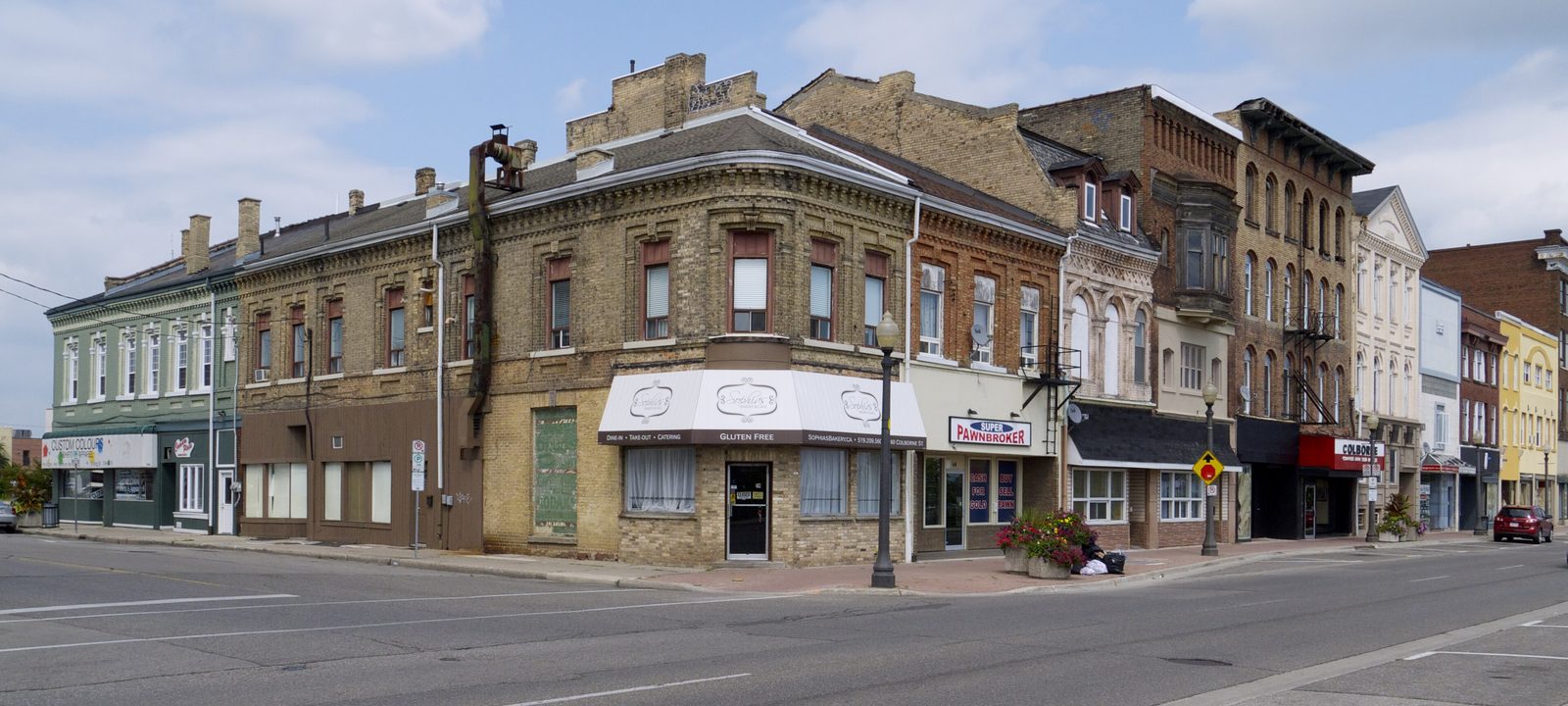
Older brick storefronts on Colborne Street at King Street in downtown Brantford
Colborne Street at King Street, downtown Brantford.
Photo: JustSomePics, CC BY-SA 4.0

About Brantford

Brantford is a city of about 105,000 on the Grand River, west of Hamilton on Highway 403. It is surrounded by the County of Brant but has governed itself as a separate city since 1877, so the city line matters when you buy: taxes, services, and bylaws differ on either side.

It sits on the Haldimand Tract, the land along the Grand granted to the Haudenosaunee after the American Revolution, and it takes its name from Joseph Brant, the Mohawk leader whose crossing of the river gave the place its first name, Brant’s ford. Six Nations of the Grand River is a short drive to the southeast. Brantford also calls itself the Telephone City: Alexander Graham Bell worked out the idea of the telephone at his father’s house on Tutela Heights in 1874.

Below you’ll find the city’s story, the river and its trails, the schools and the hospital, and how people get around, then a walk through Brantford by its five wards: downtown and Eagle Place, West Brant and Tutela Heights, Holmedale and the northwest, the north end, and Echo Place and Lynden Hills.

Brantford in depth

Brant’s ford and the Telephone City

After the American Revolution, Joseph Brant led Mohawk families to the Grand River, where the Crown granted the Haudenosaunee the Haldimand Tract. The Mohawk Chapel, built in 1785, is the oldest surviving church in Ontario and one of the royal chapels in Canada, and Joseph Brant is buried there. Today the chapel and the Woodland Cultural Centre nearby tell part of the city’s story, and Six Nations of the Grand River, the most populous First Nations reserve in Canada, is just to the southeast.

The town grew along the river and the railway in the middle of the 1800s, and it became a separate city in 1877, apart from Brant County. Alexander Graham Bell’s parents had settled on Tutela Heights, at the house now called the Bell Homestead, and it was there, in 1874, that Bell conceived the telephone; the first call over a distance was made from Brantford to Paris in August 1876.

Brantford later became an industrial city, and when Highway 403 was finished between Brantford and Ancaster in 1997, new employers followed. Downtown has since grown into a student and arts district around Laurier Brantford, Harmony Square, and the Sanderson Centre.

Brantford in depth

The Grand, the trails, and the parks

The Grand runs through the middle of Brantford, and you can follow it on foot or by bike along the SC Johnson Trail, the D’Aubigny Trail, and the dike trails. Waterworks Park, at 390 Grand River Avenue in Holmedale, has the Rotary Bike Park, and Glenhyrst Art Gallery, in Glenhyrst Gardens, is along the trails too.

Brant Conservation Area, run by the Grand River Conservation Authority on the city’s west side, has camping, swimming, and paddling a few minutes from downtown. Across the city, neighbourhood parks sit alongside larger playing fields such as the Steve Brown Sports Complex and the John Wright Soccer Complex.

Brantford in depth

The city and the County of Brant

The City of Brantford and the County of Brant are separate municipalities, and the county wraps all the way around the city, taking in Paris, St. George, and Burford. In 2017, about 2,700 hectares moved from the county into the city in a boundary adjustment, so some addresses that were once in the county are now in Brantford. When you buy near the edge, it is worth checking which side of the line a property is on.

Brantford in depth

Schools, colleges, and the hospital

Public schools are run by the Grand Erie District School Board and Catholic schools by the Brant Haldimand Norfolk Catholic District School Board. The public high schools are Brantford Collegiate Institute on Brant Avenue, North Park Collegiate on North Park Street, Pauline Johnson Collegiate on Colborne Street East, and Tollgate Technological Skills Centre on Tollgate Road; the Catholic high schools are Assumption College on Shellard Lane and St. John’s College on Paris Road. There is a French Catholic elementary school, Sainte-Marguerite-Bourgeoys, on Clench Avenue, and the W. Ross Macdonald School, the provincial school for blind and deafblind students, is on Brant Avenue. Boundaries change, so it is worth checking an address with the board before you buy.

Wilfrid Laurier University and Conestoga College both have downtown campuses. Brantford General Hospital is at 200 Terrace Hill Street.

Brantford in depth

Getting around

Highway 403 runs right through the city, so Hamilton is about 35 to 40 minutes away and Kitchener-Waterloo about 45. Wayne Gretzky Parkway and King George Road connect the north end to the highway.

The VIA Rail station, on Wadsworth Street near downtown, is on the line between Toronto and Windsor, and GO Transit buses connect Brantford with the Aldershot GO station in Burlington. Brantford Transit runs the city buses from its terminal downtown.

Ward 5

Downtown, Eagle Place, and the east side

Ward 5 holds downtown, inside the bend of the Grand, along with Eagle Place across the river to the south and the older streets east of downtown along Colborne Street East.

Map of Downtown, Eagle Place, and the east side in Brantford: the city wards in this part are shaded, with the rivers, main roads, and parks. Each place in our guide is marked; choose one to read about it.DowntownEagle PlaceColborne East
City of Brantford open data and OpenStreetMap

Inside the bend of the Grand

Downtown

Downtown runs along Colborne and Dalhousie streets, around Harmony Square. Laurier Brantford and Conestoga College have campuses here, the Sanderson Centre for the Performing Arts is close by, and the main library, the farmers’ market, and the Civic Centre are a few blocks apart. Victoria Square holds the Joseph Brant memorial.

Homes

Older homes, apartments, and student housing close to the campuses.

Streets and landmarks

Colborne, Dalhousie, Market, and King streets.

Parks and green space

Harmony Square, Victoria Square, and the river trails at Brant’s Crossing.

Schools

Central Public School, on George Street.

In the city’s ward: Ward 5.

South of the river

Eagle Place

Eagle Place, across the Grand from downtown, began as a separate settlement and was later taken into the city, and it’s one of the city’s most historic neighbourhoods. The Mohawk Chapel is close by on Mohawk Street, and the Eagle Place Community Centre, Tutela Park, and Moose Park are in the neighbourhood.

Homes

Updated older homes and newer infill, with some of the most approachable prices in the city.

Streets and landmarks

Eagle Avenue, Erie Avenue, Tecumseh Street, and Mohawk Street.

Parks and green space

Tutela Park, Moose Park, Bellview Park, and the John Wright Soccer Complex.

Schools

Princess Elizabeth and Bellview public schools, and Madonna Della Libera Catholic School.

In the city’s ward: Ward 5.

East of downtown

Colborne Street East and Mohawk Park

East of downtown, the older streets between Colborne Street East and the river run toward Mohawk Park. Pauline Johnson Collegiate is on Colborne Street East, and Alexandra Park and Iroquois Park are among the neighbourhood greens.

Homes

Older homes on the streets off Colborne Street East.

Streets and landmarks

Colborne Street East, Rawdon Street, and Marlborough Street.

Schools

Pauline Johnson Collegiate, King George and Major Ballachey public schools, and Holy Cross Catholic School.

In the city’s ward: Ward 5.

Ward 1

West Brant and Tutela Heights

Ward 1 is the southwest of the city, across the Grand from downtown: Tutela Heights and the Bell Homestead along the river, and the newer subdivisions of West Brant beyond.

Map of West Brant and Tutela Heights in Brantford: the city wards in this part are shaded, with the rivers, main roads, and parks. Each place in our guide is marked; choose one to read about it.Tutela HeightsWest Brant
City of Brantford open data and OpenStreetMap

Southwest of downtown, near the Grand

Tutela Heights and the Bell Homestead

Tutela Heights, near the Grand southwest of downtown, was outside the city for many years and was later taken into it. The Bell Homestead National Historic Site, the house where Bell conceived the telephone, is on Tutela Heights Road, and the streets nearby lead down to Lions Park Arena and the Steve Brown Sports Complex.

Homes

Homes of different ages, with larger lots toward Tutela Heights.

Streets and landmarks

Tutela Heights Road, Clench Avenue, and Erie Avenue.

Schools

Agnes Hodge Public School and the French Catholic school Sainte-Marguerite-Bourgeoys, both on Clench Avenue.

In the city’s ward: Ward 1.

The southwest’s newer subdivisions

West Brant and Shellard Lane

West Brant is where many young families land. Subdivisions such as Wyndfield, Sienna Woods, and Nature’s Grand have gone up here, and the Shellard Lane area is its growing edge, with several schools within walking distance and parks and trails around them.

Homes

Newer detached homes with open layouts, plus townhouses.

Streets and landmarks

Shellard Lane, Blackburn Drive, Dowden Avenue, and Flanders Drive.

Parks and green space

Walter Gretzky Park, Edith Monture Park, and Shellard Forest.

Schools

Walter Gretzky and Edith Monture elementary schools, St. Basil and St. Gabriel Catholic schools, and Assumption College on Shellard Lane.

In the city’s ward: Ward 1.

Ward 2

Holmedale, Terrace Hill, and the northwest

Ward 2 runs northwest from downtown, through Holmedale and Terrace Hill to Fairview and the streets around Paris Road.

Map of Holmedale, Terrace Hill, and the northwest in Brantford: the city wards in this part are shaded, with the rivers, main roads, and parks. Each place in our guide is marked; choose one to read about it.HolmedaleTerrace HillFairview
City of Brantford open data and OpenStreetMap

Along the river, northwest of downtown

Holmedale

Holmedale began as a hamlet beside the Grand and was later taken into the city. People like it for the river views and the mature trees, and the SC Johnson Trail, Waterworks Park, and the Rotary Bike Park are close by. Brantford Collegiate Institute and the W. Ross Macdonald School are on Brant Avenue.

Homes

Century homes and older brick houses, some backing onto green space.

Streets and landmarks

Grand River Avenue, Brant Avenue, Dufferin Avenue, and Chestnut Avenue.

Parks and green space

Waterworks Park, Holmedale Park, and Dufferin Park.

Schools

Dufferin and Lansdowne-Costain public schools, Christ the King Catholic School, and Brantford Collegiate Institute.

In the city’s ward: Ward 2.

Close to downtown

Terrace Hill

Terrace Hill is a long established neighbourhood of older brick homes and tree lined streets, close to downtown. Brantford General Hospital is on Terrace Hill Street, and the VIA station is just to the south.

Homes

Older brick homes, some beautifully restored and some waiting for work.

Streets and landmarks

Terrace Hill Street, Wadsworth Street, and Brant Avenue.

Parks and green space

Robert Moore Park, City View Park, and Edward E. Goold Park.

In the city’s ward: Ward 2.

Toward Paris Road and the 403

Fairview and the northwest

Northwest of Terrace Hill, Fairview and the streets around Paris Road and Tollgate Road hold a cluster of schools, with quick access to Highway 403.

Homes

Family homes.

Streets and landmarks

Paris Road, Tollgate Road, Kent Road, and Queensway Drive.

Parks and green space

Spring Gardens Park, Carolina Park, and Regent Park.

Schools

St. John’s College, Tollgate Technological Skills Centre, Russell Reid and James Hillier public schools, and Our Lady of Providence Catholic School.

In the city’s ward: Ward 2.

Ward 3

The north end

Ward 3 is the middle of the north end, from North Park Street up through Brier Park and Greenbrier to Highway 403.

Map of The north end in Brantford: the city wards in this part are shaded, with the rivers, main roads, and parks. Each place in our guide is marked; choose one to read about it.North ParkBrier Park
City of Brantford open data and OpenStreetMap

The middle of the north end

North Park and Grand Woodlands

North Park Street runs up the middle of the north end, past North Park Collegiate and the Wayne Gretzky Sports Centre, with its pools and rinks. Grand Woodlands and Cameron Heights are to the east.

Homes

Family homes of different decades.

Streets and landmarks

North Park Street, Wood Street, Fairview Drive, and Ellenson Drive.

Parks and green space

Grandwoodlands Park, Cameron Heights Park, and Wood Street Park.

Schools

North Park Collegiate, Grandview, Prince Charles, and Centennial-Grand Woodlands public schools, and St. Pius X and St. Patrick Catholic schools.

In the city’s ward: Ward 3.

Near King George Road and the 403

Brier Park and Greenbrier

Greenbrier, just east of King George Road, and Brier Park, beside it, are established north end neighbourhoods with well kept detached homes, schools and parks close by, and shopping along King George Road. They are among the quickest spots in the city for reaching the 403.

Homes

Detached homes from the postwar decades through the 1980s.

Streets and landmarks

King George Road, Memorial Drive, Blackfriar Lane, and White Oaks Avenue.

Parks and green space

Brier Park, Greenbrier Park, Cedarland Park, and Forestwood Park.

Schools

Brier Park, Greenbrier, and Cedarland public schools, and Resurrection and St. Leo Catholic schools.

In the city’s ward: Ward 3.

Ward 4

Echo Place, Lynden Hills, and the northeast

Ward 4 is the east and northeast of the city, from Echo Place along Colborne Street East up to Lynden Hills and Branlyn.

Map of Echo Place, Lynden Hills, and the northeast in Brantford: the city wards in this part are shaded, with the rivers, main roads, and parks. Each place in our guide is marked; choose one to read about it.Echo PlaceLynden Hills
City of Brantford open data and OpenStreetMap

Along Colborne Street East

Echo Place

Echo Place stretches along Colborne Street East toward Cainsville, with Echo Park, Woodman Park, and Johnson Park among its greens and the Arrowdale golf course on Stanley Street. Families who want trails and parks close by often look here.

Homes

Postwar bungalows and later family homes.

Streets and landmarks

Colborne Street East, Woodman Drive, Glenwood Drive, and Stanley Street.

Parks and green space

Echo Park, Woodman Park, Johnson Park, Mission Park, and Orchard Park.

Schools

Echo Place and Woodman-Cainsville public schools, and St. Peter Catholic School.

In the city’s ward: Ward 4.

The northeast

Lynden Hills and Branlyn

Lynden Hills and Branlyn round out the north end on the east side, known for affordable homes, convenient shopping at Lynden Park Mall on Lynden Road, and the Branlyn Community Centre. The schools here include Branlyn Community School and Notre Dame Catholic School, which share a site on Brantwood Park Road.

Homes

Mostly family homes from the 1970s and 1980s.

Streets and landmarks

Lynden Road, Brantwood Park Road, Banbury Road, and Branlyn Crescent.

Parks and green space

Lynden Hills Park, Jaycee Park, Florence Buchanan Park, and Silverbridge Park.

Schools

Branlyn Community School, Banbury Heights School, and Notre Dame Catholic School.

In the city’s ward: Ward 4.

Sources

Written from our work with clients here and the time we have spent getting to know the city, and checked against the sources below.

Each fact was checked against at least two sources. Neighbourhood names follow local usage, and the official areas each entry covers are listed under it. The streets named are examples rather than boundaries. Details such as school boundaries, zoning, and bus routes change, so please check anything important with the municipality, the transit agency, or the school board.