County of Brant

St. George

A village of nineteenth century storefronts on the road between Brantford and Cambridge, with farm country in every direction.

8 minute read

Map of St. George: every one of the County settlement areas is shaded by the part of St. George it belongs to in our guide, with the rivers, main roads, and parks. Choose one to open it in our guide.Main StreetNorth endBeverlyStreet WestThe Oaks
County of Brant open data and OpenStreetMap
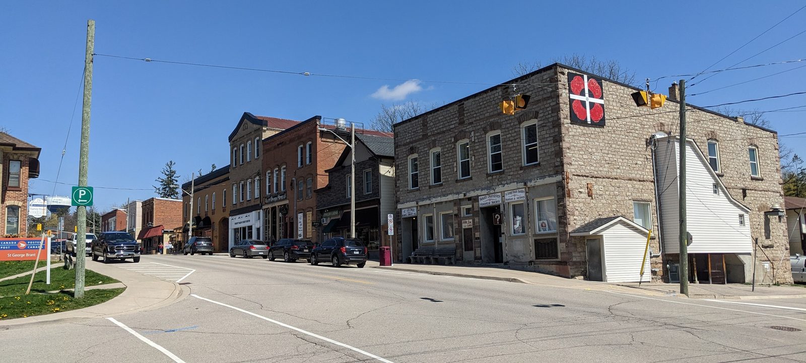
Main Street in St. George, Ontario, with the stone Memorial Hall and older storefronts
Main Street, St. George.
Photo: JFVoll, CC BY-SA 4.0

About St. George

St. George is a village in the County of Brant, north of Brantford and south of Cambridge, and South Dumfries Township had its offices here before the county became one municipality in 1999. Main Street still keeps many of its buildings from the 1800s, with antique shops, cafes, and restaurants along it.

The village began as Bauslaugh Mills, after John Bauslaugh’s sawmill, and by 1832 it had three churches and a handful of businesses. Stone came later: William Snowball’s grist mill in 1871, the Howell Block in 1891, and a brick school on Beverly Street in 1893, all still standing.

Below you’ll find the village’s story, its parks and golf, the schools, and how people get around, then a walk through the village itself, from Main Street to the west side and the country at the edges.

St. George in depth

Bauslaugh Mills and the stone village

John and Peter Bauslaugh are credited with founding St. George, and the village first went by Bauslaugh Mills, after John’s sawmill. Main Street began in the 1820s, when Henry Moe sold fish and dry goods from the first log building, and the earliest settlers came for the flowing wells and good farmland around it.

The buildings that give Main Street its character came later in the century. William Snowball began building his cut stone flour mill at 41 Main Street South in 1869, and the Countyand the mill bears the date 1871; by 1885rsquo;s heritage tour dates the mill to 1871; by 1885 steam power let it turn out 200 barrels of flour a day. Across the road, the stone Howell Block of 1891 held a drugstore, a millinery, a printing office, and a lawyer; local people bought it in 1924 to hold as a community hall, and it is now home to the South Dumfries Historical Society.

Sunnyside, at 13 Main Street South, is a Romanesque Revival house built in the late 1880s as a doctor’s home and office. It later served as the South Dumfries Township office and is a private home again. South Dumfries became part of the County of Brant on January 1, 1999.

St. George in depth

The Hoodless Homestead and AppleFest

Just west of the village, at 359 Blue Lake Road, is the farmhouse where Adelaide Hunter Hoodless was born, built around 1830. She founded the world’s first Women’s Institute, at Stoney Creek, and pushed to have domestic science taught in Ontario schools. The homestead was named a National Historic Site in 1995, and the Federation of Women’s Institutes of Canada owns it and runs it as a museum.

Every September, AppleFest takes over Main Street with vendors, food, and music. It began in 1984, and it is still run with a great deal of volunteer help.

St. George in depth

Parks, the community centre, and golf

The village has several small parks: Snowball Park and King William Park near Main Street, Sunny Hill Park on the north side, and Arena Park and Elliot Field on the west side. The Gaukel Memorial Community Centre, at 7 Gaukel Drive, took its name in 2022; it was the South Dumfries Community Centre before that, and the St. George Ravens hockey team plays there.

Two golf courses are close. The Oaks of St. George is just southwest of the village, and Brant Valley is to the southeast, toward Brantford.

St. George in depth

Schools and the library

St. George-German Public School, on College Street, is the village’s elementary school, run by the Grand Erie District School Board. Catholic schools are run by the Brant Haldimand Norfolk Catholic District School Board, and there is no high school in the village, so older students travel for school. Boundaries change, so it is worth checking an address with the board before you buy.

The old school of 1893, at 39 Beverly Street West, was replaced in 1973 by a newer building behind it and now holds a nursery school and day care. The St. George branch of the Brant library is at 78 Main Street North.

St. George in depth

Getting around

Most people here drive. Beverly Street, County Highway 5, runs east and west through the village, Highway 24 heads south into Brantford as Brant Road, and St. George Road leads north toward Cambridge. Brantford and Cambridge are each roughly 15 to 20 minutes away, and Highway 403 is the way to Hamilton.

Where the village began

Main Street and the old village

The old village runs along Main Street, from the stone blocks south of Beverly Street to the library and the streets climbing north toward St. George Road.

Map of Main Street and the old village in St. George: the County settlement areas in this part are shaded, with the rivers, main roads, and parks. Each place in our guide is marked; choose one to read about it.Main StreetNorth end
County of Brant open data and OpenStreetMap

The village core

Main Street

Main Street is where St. George began, and many of its buildings date from the 1800s. The Snowball grist mill of 1871 is at 41 Main Street South, the Howell Block and the Memorial Community Hall share the stone front at 34 and 36, and Sunnyside stands at number 13. The St. George-South Dumfries Museum is here too, in the Howell Block.

Homes

Century homes and older brick houses on the side streets, some on deep lots.

Streets and landmarks

Main Street North and South, Beverly Street, High Street, and Scott Street.

Parks and green space

Snowball Park and King William Park are a short walk from Main Street.

Day to day

Antique shops, cafes, and restaurants, with bigger shopping in Brantford or Cambridge.

On the County’s settlement map: St. George.

Up Main Street North

The north end

North of the core, Main Street North runs past the library at number 78 and becomes St. George Road on its way toward Cambridge. Sunny Hill Park is on this side of the village, and the streets around it are residential.

Homes

Older homes along Main Street North and family homes on the side streets.

Streets and landmarks

Main Street North and St. George Road.

Getting around

St. George Road leads north toward Cambridge.

On the County’s settlement map: St. George.

Beverly Street West and beyond

The west side and the edges

West of Main Street, Beverly Street leads past the school and the community centre toward Highway 24, with newer streets on either side and a large new subdivision planned.

Map of The west side and the edges in St. George: the County settlement areas in this part are shaded, with the rivers, main roads, and parks. Each place in our guide is marked; choose one to read about it.Beverly Street WestThe Oaks
County of Brant open data and OpenStreetMap

The school, the arena, and the playing fields

Beverly Street West

Beverly Street West carries County Highway 5 out of the village, past the old school of 1893 at number 39. St. George-German Public School is just south on College Street, and the Gaukel Memorial Community Centre, Arena Park, and Elliot Field are close by. A large subdivision is planned on Beverly Street West, with single family homes and townhouses in phases.

Homes

Family homes on the streets off Beverly Street, with new construction planned to the west.

Streets and landmarks

Beverly Street West, College Street, Gaukel Drive, and Thompson Street.

Schools

St. George-German Public School, on College Street.

On the County’s settlement map: St. George.

Toward Brant Road

Highway 5 west and The Oaks

Between the village and Brant Road, the settlement area takes in The Oaks of St. George golf course and the land along Highway 5 to the west. Blue Lake Road and the Hoodless Homestead are just beyond.

Homes

Country properties and larger lots.

Getting around

Brant Road, Highway 24, runs south into Brantford.

On the County’s settlement map: St. George.

Sources

Written from our work with clients here and the time we have spent getting to know the village, and checked against the sources below.

Each fact was checked against at least two sources. Neighbourhood names follow local usage, and the official areas each entry covers are listed under it. The streets named are examples rather than boundaries. Details such as school boundaries, zoning, and bus routes change, so please check anything important with the municipality, the transit agency, or the school board.