York Region

Markham

Two old main streets, a growing downtown with a new university campus, and the Rouge valley running down its east side, all in one of the largest cities in the GTA.

8-minute read

Map of Markham: every one of the city boundary is shaded by the part of Markham it belongs to in our guide, with the rivers, main roads, and parks. Choose one to open it in our guide.UnionvilleDowntownMarkhamVillageCornellThornhillMillikenBerczy andAngus Glen
Ontario Municipal Boundaries, Nominatim, and OpenStreetMap contributors
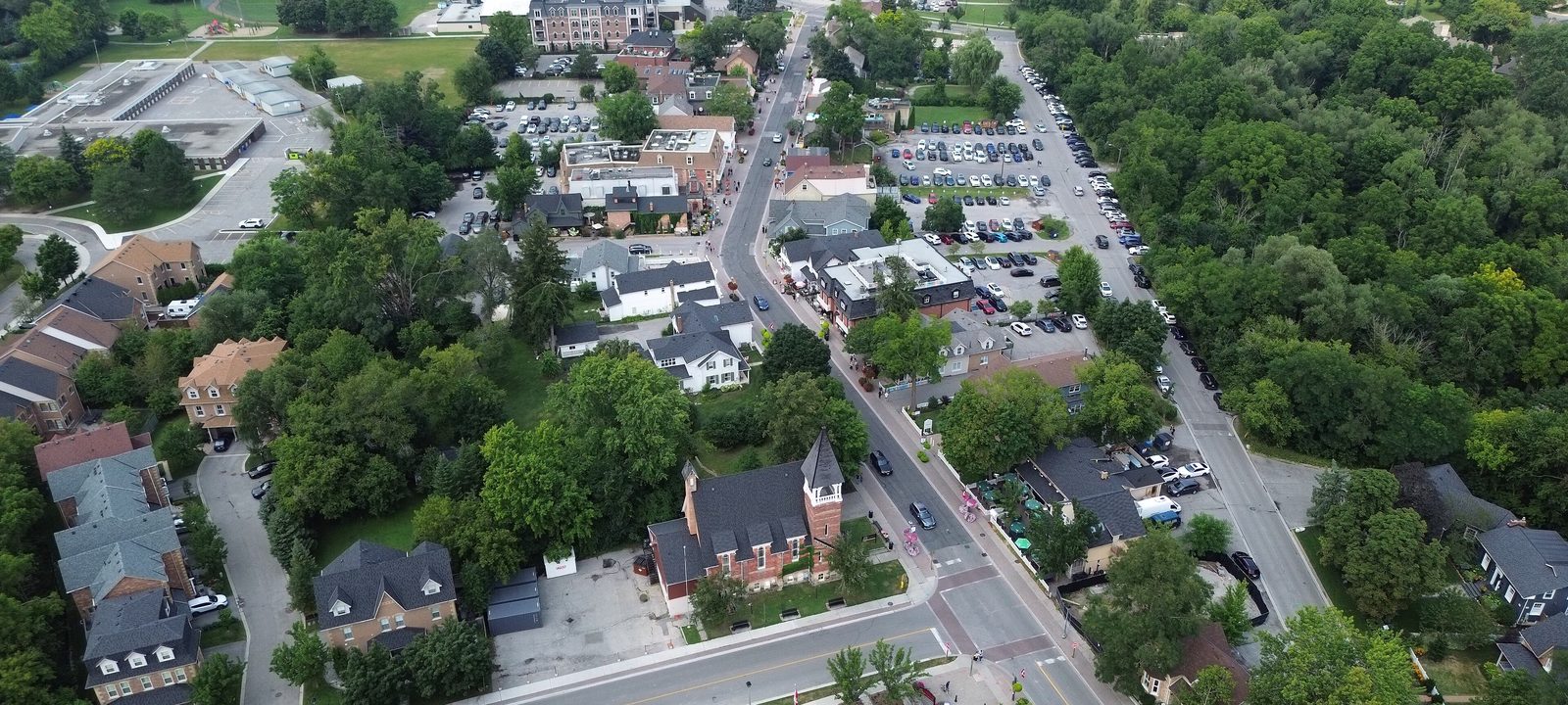
An aerial view of Main Street Unionville, a two-lane street lined with brick and clapboard buildings, a church with a steeple, and mature trees all around
Main Street Unionville, from above.
Photo: Nath87, CC0

About Markham

Markham lies northeast of Toronto, between Richmond Hill and Pickering, and is home to about 338,000 people. Its story begins in 1794, when William Berczy brought 64 German families to settle the township. Mills and villages grew along the Rouge River and its creeks, and two of them, Unionville and Markham Village, still have the main streets that grew up around them before the railway arrived in 1871.

Today Markham is a city of many communities: the two old villages, Thornhill along Yonge Street, newer neighbourhoods like Cornell, Berczy, and Angus Glen, and a downtown taking shape around Highway 7, where York University opened its Markham campus in 2024. The Rouge valley, now part of Rouge National Urban Park, runs down the east side.

Below you’ll find the main streets and the Rouge, the hospital and the new campus, schools, and how to get around, then a walk through Markham, from Unionville and Markham Village to Thornhill and the north.

Markham in depth

Two main streets

Main Street Unionville runs from Toogood Pond down to the Rouge River and is protected as a heritage district, with shops, restaurants, and the Varley Art Gallery in and around its 1800s buildings. Unionville Station, built in 1871 for the Toronto and Nipissing Railway, still stands on its original site and is now a community centre.

Markham Village grew around its mills and taverns on the Rouge, took the name Markham when its post office opened in 1828, and was incorporated in 1873, two years after the railway arrived. Its Main Street became a heritage district in 1990.

Markham in depth

The Rouge and the outdoors

Rouge National Urban Park was established in 2015 as Canada’s first national urban park, and at about 79 square kilometres it’s the largest urban park in North America. It follows the Rouge River and Little Rouge Creek through the east side of Markham and down into Toronto, with trails, farmland, and forest. Each fall, the Markham Fair fills its fairgrounds at McCowan Road and Elgin Mills Road.

For golf, Angus Glen, which has hosted the Canadian Open twice, has two public courses in the north of the city, and Markham also has two private clubs in Thornhill.

Markham in depth

The hospital and the new campus

Markham Stouffville Hospital opened in 1990 and is now part of Oak Valley Health. York University’s Markham Campus opened in downtown Markham in 2024, and the Markham Pan Am Centre, built for the 2015 Pan Am Games, is close by, with pools and gyms open to the public.

Markham in depth

Schools

Public schools are run by the York Region District School Board, and Catholic schools by the York Catholic District School Board, with French-language schools as well. Public high schools include Unionville, Bill Crothers, Markville, Markham District, Bur Oak, Pierre Elliott Trudeau, Bill Hogarth, Middlefield, and Milliken Mills. Catholic high schools include Father Michael McGivney, St. Augustine, and St. Brother André. Boundaries change as the city grows, so it is worth checking an address with the board before you buy.

Markham in depth

Getting around

GO trains on the Stouffville line stop at Milliken, Unionville, Centennial, Markham, and Mount Joy. Viva buses run along Highway 7, Highway 404 runs up the west side of the city, Highway 407 crosses the south, and Highway 48, Markham Road, runs north through Markham Village.

Main Street and Highway 7

Unionville and downtown

Old Unionville and its Main Street, and downtown Markham taking shape to the south along Highway 7.

Map of Unionville and downtown in Markham: the city boundary in this part are shaded, with the rivers, main roads, and parks. Each place in our guide is marked; choose one to read about it.UnionvilleDowntown
Ontario Municipal Boundaries, Nominatim, and OpenStreetMap contributors

Main Street and Toogood Pond

Unionville

Old Unionville centres on Main Street, a heritage district of shops, restaurants, and 1800s buildings that runs from Toogood Pond to the Rouge River. The Varley Art Gallery is here, along with the old railway station. Around it, streets of homes from many decades spread out in every direction.

Homes

Heritage homes near Main Street and family homes of many decades around it.

Day to day

Main Street’s shops and restaurants, and the park at Toogood Pond.

On the city map: City of Markham.

Around Highway 7 and Enterprise Boulevard

Downtown Markham

South of Unionville, along Highway 7 and Enterprise Boulevard, downtown Markham is a newer district of condos, offices, and shops, with York University’s Markham Campus, the Pan Am Centre, and Unionville High School.

Homes

Mostly condos and townhouses.

Getting around

Viva on Highway 7 and Unionville GO nearby.

On the city map: City of Markham.

The east side

Markham Village and Cornell

The old Markham Village on Main Street and Highway 48, and the planned community of Cornell to the east.

Map of Markham Village and Cornell in Markham: the city boundary in this part are shaded, with the rivers, main roads, and parks. Each place in our guide is marked; choose one to read about it.Markham VillageCornell
Ontario Municipal Boundaries, Nominatim, and OpenStreetMap contributors

Main Street and the Rouge

Markham Village

Markham Village grew along Main Street near the Rouge River and is now a heritage district, with shops and restaurants in its old buildings, the GO station, and Markham District High School. Residential streets of many decades surround it.

Homes

Heritage homes near Main Street and family homes around them.

Getting around

Markham GO and Highway 48.

On the city map: City of Markham.

A planned community

Cornell

East of Ninth Line and north of Highway 407, Cornell was planned in the 1990s by the firm Duany Plater-Zyberk around walkable streets, with front porches facing the sidewalk and garages tucked onto rear lanes. Markham Stouffville Hospital is on its edge, and Bill Hogarth Secondary School is in the neighbourhood.

Homes

Detached homes, semis, and townhouses on lanes, with some condos.

Health

Markham Stouffville Hospital.

On the city map: City of Markham.

The west and the south

Thornhill and Milliken

The Markham side of Thornhill, east of Yonge Street, and Milliken along the south edge of the city.

Map of Thornhill and Milliken in Markham: the city boundary in this part are shaded, with the rivers, main roads, and parks. Each place in our guide is marked; choose one to read about it.ThornhillMilliken
Ontario Municipal Boundaries, Nominatim, and OpenStreetMap contributors

The Markham side of Yonge Street

Thornhill

East of Yonge Street, the Markham half of Thornhill has its own heritage district around the old village, with 138 protected properties, and streets of family homes stretching east toward Bayview Avenue. The Ladies’ Golf Club of Toronto and the Bayview Golf and Country Club are both here.

Homes

Heritage homes near Yonge Street and family homes of many decades.

History

The Thornhill-Markham Heritage Conservation District.

On the city map: City of Markham.

The south edge

Milliken

Milliken runs along the south edge of the city near Steeles Avenue and Kennedy Road, with Milliken GO station on the Stouffville line and Milliken Mills High School on Kennedy Road.

Homes

Family homes and townhouses.

Getting around

Milliken GO.

On the city map: City of Markham.

Newer neighbourhoods

Berczy and Angus Glen

Newer neighbourhoods in the north of the city, around Kennedy Road and Major Mackenzie Drive.

Map of Berczy and Angus Glen in Markham: the city boundary in this part are shaded, with the rivers, main roads, and parks. Each place in our guide is marked; choose one to read about it.Berczy and Angus Glen
Ontario Municipal Boundaries, Nominatim, and OpenStreetMap contributors

Newer neighbourhoods

Berczy and Angus Glen

In the north of the city, Berczy Village, named for Markham’s founder, and Angus Glen, around the golf club of the same name, are neighbourhoods of newer family homes, with Pierre Elliott Trudeau High School nearby.

Homes

Newer detached homes and townhouses.

Recreation

Angus Glen Golf Club and Community Centre.

On the city map: City of Markham.

Everyday drives

Real drives, day to day

Drives from this area to universities and colleges, major employers, hospitals, GO stations, and more, sorted nearest first. Downtown trips show the transit time first, from TTC and GO schedules checked against Google Maps; other times are by car without traffic.

See all 19 drives for this area on a map
Universities and collegesNearest about 15 minutes
  • From Unionville to Seneca, Newnham campus: about 15 minutesCollege13 km by road, without traffic
  • From Unionville to Centennial College, Progress campus: about 21 minutesCollege15 km by road, without traffic
  • From Unionville to York University, Keele campus: about 21 minutesUniversity22 km by road, without traffic
  • From Unionville to University of Toronto, Scarborough campus: about 23 minutesUniversity20 km by road, without traffic
Major employersNearest about 42 minutes
  • From Unionville to GM, Oshawa Assembly plant: about 42 minutes48 km by road, without traffic
  • From Unionville to First Canadian Place, Financial District: about 50 minutes by GO train (about 30 minutes by car without traffic)Stouffville GO train · drive 32 km by road
HospitalsNearest under 10 minutes
  • From Cornell to Markham Stouffville Hospital: under 10 minutes1.4 km by road, without traffic
GO stations and Union StationNearest about 45 minutes by GO train
  • From Unionville to Union Station, Toronto: about 45 minutes by GO train (about 31 minutes by car without traffic)Stouffville GO train · drive 33 km by road
Highway on-rampsNearest about 12 minutes
  • From Berczy to Highway 404 at Major Mackenzie Drive: about 12 minutes7.8 km by road, without traffic
AirportsNearest about 42 minutes
  • From Unionville to Pearson Airport: about 42 minutes48 km by road, without traffic
Parks and outdoorsNearest under 10 minutes
  • From Unionville to Toogood Pond Park: under 10 minutes2.9 km by road, without traffic
  • From Cornell to Rouge National Urban Park: about 19 minutes13 km by road, without traffic
Schools, markets, and main streetsNearest about 10 minutes
  • From Markham Village to Main Street Unionville: about 10 minutes6.1 km by road, without traffic

Selling

Selling a larger home in Markham

Selling a larger home in Markham takes a careful price, good preparation, and strong photography. You deal with the two of us directly, from the first visit to closing day, and your plans stay confidential until you’re ready.

Book a conversation

Markham

Questions people ask

Who can help me buy or sell a home in Markham?

Reach out any time. We’re Tanner Hickey and Robin Hickey, Sales Representatives with RE/MAX Real Estate Centre Inc., Brokerage, based in Cambridge and working with clients across Ontario. Call Tanner at 519-716-4806 or Robin at 519-240-8984, or book a conversation.

What’s Markham like as a place to live?

Markham is a city of many communities. Unionville and Markham Village still have their old main streets, and newer neighbourhoods like Cornell, Berczy, and Angus Glen have grown around them. The Rouge valley, part of Rouge National Urban Park, runs down the east side.

How far is Markham from downtown Toronto?

On a clear road, under half an hour to Union Station. York University’s new Markham campus, opened in 2024, sits in the downtown taking shape along Highway 7.

Who can help me sell a larger home in Markham?

We’d be glad to. Robin has been selling real estate since 1985 and Tanner since 2018, and with a larger home that experience shows in the details: a careful price, a house that shows well, and privacy if you’d rather the neighbours not know yet. Here’s how we sell family and larger homes.

Book a conversation

Sources

Written from our work with clients here and the time we have spent getting to know the city, and checked against the sources below.

Each fact was checked against at least two sources. Neighbourhood names follow local usage, and the official areas each entry covers are listed under it. The streets named are examples rather than boundaries. Details such as school boundaries, zoning, and bus routes change, so please check anything important with the municipality, the transit agency, or the school board.