York Region

Richmond Hill

A city along Yonge Street, from an old village and its mill pond up to the kettle lakes of the Oak Ridges Moraine, with Canada’s largest telescope in the middle of it all.

7-minute read

Map of Richmond Hill: every one of the city boundary is shaded by the part of Richmond Hill it belongs to in our guide, with the rivers, main roads, and parks. Choose one to open it in our guide.Old villageSouth endBayview HillOak Ridges
Ontario Municipal Boundaries, Nominatim, and OpenStreetMap contributors
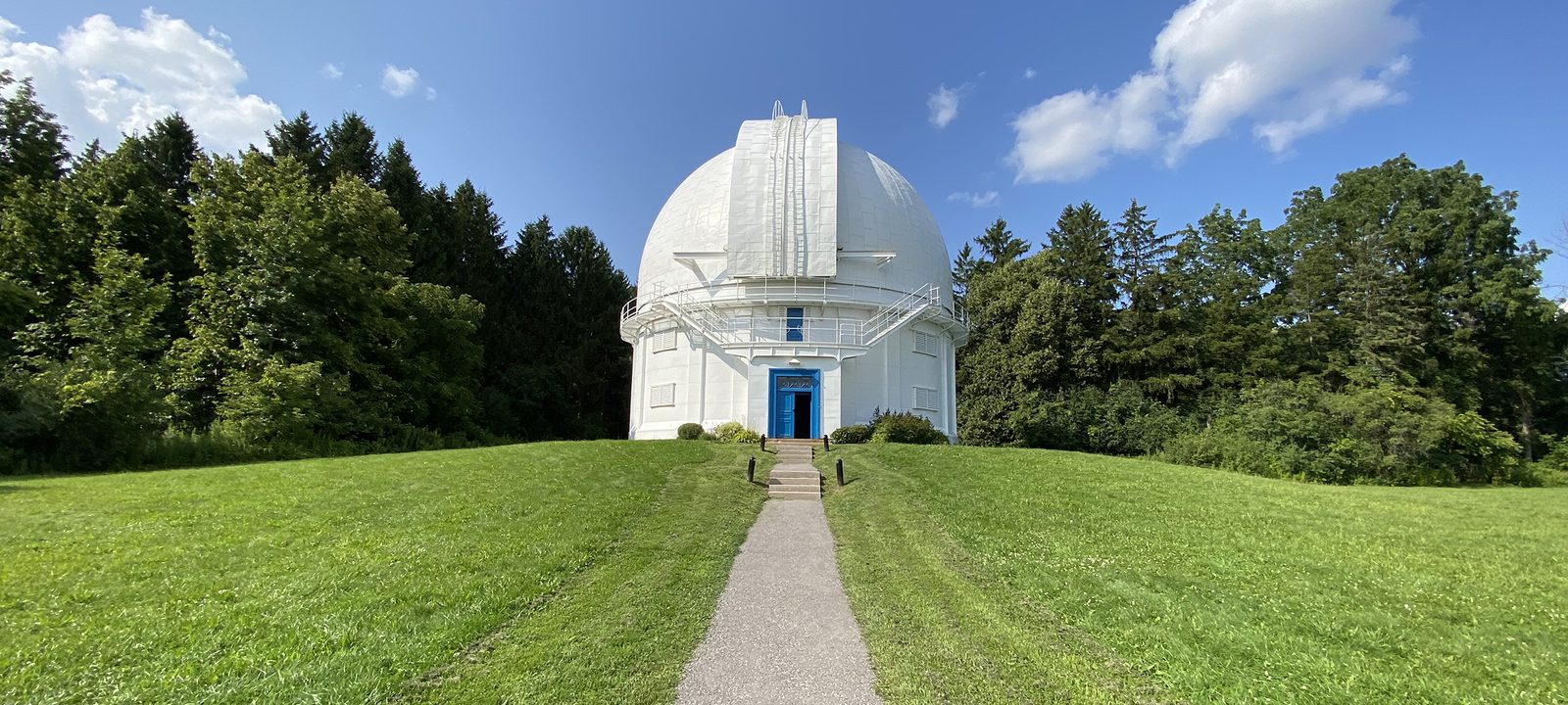
The white dome of the David Dunlap Observatory at the top of a grassy hill, with a paved path leading up to its blue door and tall evergreens on either side
The David Dunlap Observatory, in Observatory Park.
Photo: Canmenwalker, CC BY 4.0

About Richmond Hill

Richmond Hill runs north along Yonge Street from Highway 7, between Vaughan to the west and Markham to the east, and is home to about 202,000 people. It began as a village on Yonge Street, incorporated in 1873, became a town in 1957, and a city in 2019. Oak Ridges and Lake Wilcox, to the north, became part of it in 1971.

It has grown a great deal since the 1990s, but the old village and Mill Pond are still at its centre, the David Dunlap Observatory still sits on its hill, and the north end reaches up into the Oak Ridges Moraine, with Lake Wilcox, the largest kettle lake on the moraine.

Below you’ll find the observatory, the lakes and parks, the hospital, schools, and how to get around, then a walk through Richmond Hill: the old village, the south end, the east side, and Oak Ridges.

Richmond Hill in depth

The observatory

The David Dunlap Observatory opened on May 31, 1935, and its 74-inch telescope is still the largest in Canada. The dome, the telescope, and the old administration building are now part of the city’s Observatory Park, which hosts public programs. Because of the observatory, Richmond Hill has a bylaw that limits light pollution, to help keep the night sky dark.

Richmond Hill in depth

Lakes and parks

Mill Pond Park, near the old village, is a pond that once powered a sawmill, with a boardwalk and a trail around it, and summer concerts in the park. In the north, Lake Wilcox Park has a boardwalk, a splash pad, and a promenade along the largest kettle lake on the Oak Ridges Moraine, and the trails of the moraine run through the woods around it. Richmond Green, in the east, has sports fields, arenas, and space for events.

For golf, Richmond Hill has public courses on Bathurst Street and in the north end, and the private Summit Golf Club on Yonge Street.

Richmond Hill in depth

The hospital and the arts

Mackenzie Richmond Hill Hospital, run by Mackenzie Health, is on Trench Street near Yonge Street and Major Mackenzie Drive. A short way south, the Richmond Hill Centre for the Performing Arts opened on Yonge Street in 2009.

Richmond Hill in depth

Schools

Public schools are run by the York Region District School Board, and Catholic schools by the York Catholic District School Board, with French-language schools as well. Public high schools include Alexander Mackenzie, Bayview, Langstaff, Richmond Green, and Richmond Hill High School. Catholic high schools include Our Lady Queen of the World Academy and St. Theresa of Lisieux. Boundaries change, so check the address with the school boards before you buy.

Richmond Hill in depth

Getting around

GO trains on the Richmond Hill line stop at four stations in the city, Langstaff, Richmond Hill, Gormley, and Bloomington, and service has run here since 1978. Viva buses run along Yonge Street and Highway 7, Highway 404 runs along the east side of the city, and Highway 407 runs along the south.

The Yonge North Subway Extension will bring Line 1 north from Finch to Richmond Hill Centre, at Highway 7 and Yonge Street. Early work has begun, but no opening date has been set.

Yonge Street and Mill Pond

The old village

The old village on Yonge Street, around Major Mackenzie Drive, with Mill Pond just to the west.

Map of The old village in Richmond Hill: the city boundary in this part are shaded, with the rivers, main roads, and parks. Each place in our guide is marked; choose one to read about it.Old villageMill Pond
Ontario Municipal Boundaries, Nominatim, and OpenStreetMap contributors

Yonge Street

The old village

The old village runs along Yonge Street around Major Mackenzie Drive, with heritage buildings, shops, and restaurants, the hospital on Trench Street, and the performing arts centre a short way south. Streets of older homes lead off Yonge on both sides.

Homes

Heritage homes and older houses near Yonge Street, with newer infill and condos.

Day to day

Shops and restaurants on Yonge Street, the hospital, and the theatre.

On the city map: City of Richmond Hill.

The pond and the heritage streets

Mill Pond

Mill Pond is just west of the old village, a park around a pond that once powered a sawmill, with a boardwalk, a trail, and summer concerts. Heritage homes and residential streets surround it.

Homes

Heritage homes and family houses from many decades.

Parks and green space

Mill Pond Park.

On the city map: City of Richmond Hill.

The observatory and Highway 7

The south end

South of 16th Avenue, from the observatory down to Highway 7 and Richmond Hill Centre.

Map of The south end in Richmond Hill: the city boundary in this part are shaded, with the rivers, main roads, and parks. Each place in our guide is marked; choose one to read about it.South end
Ontario Municipal Boundaries, Nominatim, and OpenStreetMap contributors

The observatory and Richmond Hill Centre

The south end

South of 16th Avenue, Observatory Park and the David Dunlap Observatory sit on their hill, with newer homes on the land around them. Further south, condo towers have gone up around Yonge Street and Highway 7, near Langstaff GO and the bus terminal, where the subway is planned to end.

Homes

Family homes, newer streets near the observatory, and condos near Highway 7.

Getting around

Langstaff GO, the bus terminal, and Highways 7 and 407.

On the city map: City of Richmond Hill.

Bayview and Richmond Green

The east side

East toward Bayview Avenue and Leslie Street, with Bayview Hill and Richmond Green.

Map of The east side in Richmond Hill: the city boundary in this part are shaded, with the rivers, main roads, and parks. Each place in our guide is marked; choose one to read about it.Bayview Hill
Ontario Municipal Boundaries, Nominatim, and OpenStreetMap contributors

The east side

Bayview Hill and Richmond Green

East toward Bayview Avenue, Bayview Hill is a neighbourhood of family homes, with Bayview Secondary School on Bayview Avenue. To the northeast, Richmond Green Park and Sports Centre on Elgin Mills Road has fields and arenas, with Richmond Green Secondary School close by.

Homes

Family homes, many on larger lots.

Recreation

Richmond Green Park and Sports Centre.

On the city map: City of Richmond Hill.

The moraine

Oak Ridges and Lake Wilcox

The north end of the city, up on the Oak Ridges Moraine, around Lake Wilcox.

Map of Oak Ridges and Lake Wilcox in Richmond Hill: the city boundary in this part are shaded, with the rivers, main roads, and parks. Each place in our guide is marked; choose one to read about it.Oak Ridges
Ontario Municipal Boundaries, Nominatim, and OpenStreetMap contributors

The moraine

Oak Ridges and Lake Wilcox

Oak Ridges grew up along Yonge Street on the Oak Ridges Moraine and became part of Richmond Hill in 1971. Lake Wilcox is at its centre, with Lake Wilcox Park on the shore, and trails through the woods and wetlands of the moraine all around.

Homes

Older homes near the lake, family subdivisions, and newer homes.

Parks and green space

Lake Wilcox Park and the moraine trails.

On the city map: City of Richmond Hill.

Everyday drives

Real drives, day to day

Drives from this area to universities and colleges, major employers, hospitals, GO stations, and more, sorted nearest first. Times are by car without traffic.

See all 19 drives for this area on a map
Universities and collegesNearest about 19 minutes
  • From the old village to York University, Markham campus: about 19 minutesUniversity16 km by road, without traffic
  • From the old village to Seneca, Newnham campus: about 19 minutesCollege17 km by road, without traffic
  • From the old village to Seneca, King campus: about 22 minutesCollege15 km by road, without traffic
  • From the old village to Humber College, North campus: about 28 minutesCollege27 km by road, without traffic
Major employersNearest about 35 minutes
  • From the old village to First Canadian Place, Financial District: about 35 minutes36 km by road, without traffic
  • From the old village to Ford, Oakville Assembly Complex: about 50 minutes57 km by road, without traffic
HospitalsNearest under 10 minutes
  • From the old village to Mackenzie Richmond Hill Hospital: under 10 minutes1.4 km by road, without traffic
GO stations and Union StationNearest under 10 minutes
  • From the old village to Richmond Hill GO Station: under 10 minutes1.8 km by road, without traffic
  • From the old village to Union Station, Toronto: about 35 minutes37 km by road, without traffic
Highway on-rampsNearest about 8 minutes
  • From Bayview Hill to Highway 404 at Major Mackenzie Drive: about 8 minutes4.9 km by road, without traffic
AirportsNearest about 42 minutes
  • From Bayview Hill to Pearson Airport: about 42 minutes43 km by road, without traffic
Parks and outdoorsNearest under 10 minutes
  • From the old village to Mill Pond Park: under 10 minutes2.6 km by road, without traffic
GolfNearest about 17 minutes
  • From Bayview Hill to Bloomington Downs Golf Course: about 17 minutes12 km by road, without traffic

Selling

Selling a larger home in Richmond Hill

Selling a larger home in Richmond Hill takes a careful price, good preparation, and strong photography. You deal with the two of us directly, from the first visit to closing day, and your plans stay confidential until you’re ready.

Book a conversation

Richmond Hill

Questions people ask

Who can help me buy or sell a home in Richmond Hill?

That’s us. We’re Tanner Hickey and Robin Hickey of RE/MAX Real Estate Centre Inc., Brokerage, based in Cambridge, with clients across Ontario. It’s the two of us from the first conversation to closing. Call Tanner at 519-716-4806 or Robin at 519-240-8984, or book a conversation.

What’s it like to live in Richmond Hill?

It’s grown a lot since the 1990s, but the old village and Mill Pond are still at the centre, and the David Dunlap Observatory still sits on its hill. Up north, Oak Ridges reaches into the moraine, around Lake Wilcox.

How long is the drive to downtown Toronto?

About 35 minutes to Union Station without traffic. Yonge Street runs right through the city, so it’s a straight shot in.

Who can help me sell a larger home in Richmond Hill?

That’s us. We’ll walk through the house with you, tell you what’s worth doing before you list and what you can leave alone, and plan the photos and the timing around your next move. To see where your home stands, ask for an opinion of value.

Book a conversation

Sources

Written from our work with clients here and the time we have spent getting to know the city, and checked against the sources below.

Each fact was checked against at least two sources. Neighbourhood names follow local usage, and the official areas each entry covers are listed under it. The streets named are examples rather than boundaries. Details such as school boundaries, zoning, and bus routes change, so please check anything important with the municipality, the transit agency, or the school board.