Middlesex County

London

Southwestern Ontario’s largest city, where the two branches of the Thames meet, with a university, a college, three hospitals, and old brick neighbourhoods within a walk or a short bike ride of downtown.

18-minute read

Map of London: every one of the planning districts is shaded by the part of London it belongs to in our guide, with the rivers, main roads, and parks. Choose one to open it in our guide.DowntownWoodfieldOld NorthMasonvilleStoneybrookHyde ParkHuron HeightsArgyleHamilton RoadWortleyVillageHighlandWhite OaksPond MillsOakridgeByronLambeth
City of London Open Data (planning districts) and OpenStreetMap contributors
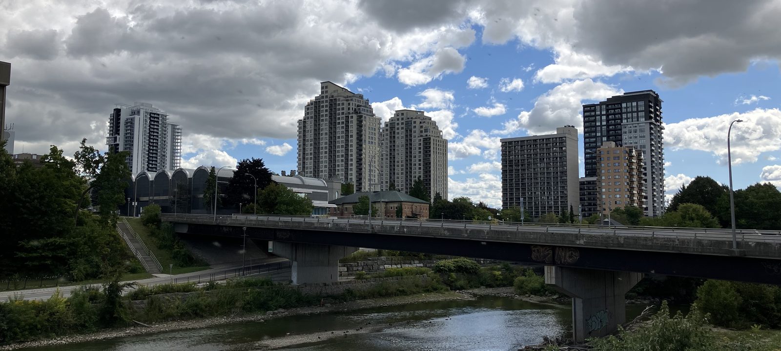
Downtown London towers rising above the Thames, with a road bridge crossing the river and trees along both banks
Downtown London above the Thames.
Photo: Gogerr, CC BY 4.0

About London

London is a city of about 422,000 where the North Thames and the Thames meet, about 200 kilometres west of Toronto. John Graves Simcoe chose the site in 1793 and named the town and the river for the ones in England. It grew into the centre of Southwestern Ontario, and today it’s a city of learning and health care, home to Western University, Fanshawe College, and three major hospitals.

What people notice first is how green it is. Parks follow the river through the middle of the city, the Thames Valley Parkway runs for about 45 kilometres along the water, and the older neighbourhoods have streets of century homes under tall trees. Further out, the city grew in rings after it annexed Byron, Masonville, and its other neighbours in 1961, and then Lambeth and most of Westminster Township in 1993.

Below you’ll find the river and the parks, downtown, the schools, Western and Fanshawe, the hospitals, and how people get around. Then we walk the city part by part: the core, the north end, the east end, the south end, and the west side, using the City’s own planning districts so every corner of London is covered.

London in depth

The Thames and the parks

The Thames runs through everything here. Its two branches meet downtown at the Forks, where Museum London sits on the bank, and the parks follow the water out from there: Harris Park on Ridout Street North, Gibbons Park in Old North, and Springbank Park to the west, the largest in the city at 120 hectares, with Storybook Gardens for children.

The Thames Valley Parkway, a paved path about 45 kilometres long, links most of them for walking and cycling. In the northeast, the Fanshawe Dam holds back the North Thames to make Fanshawe Lake, finished in 1952 after the great flood of 1937, and the conservation area around it has camping, trails, and Fanshawe Pioneer Village. The Sifton Bog, in the west end, is one of the most southerly acidic bogs in Canada, with a boardwalk from Oxford Street out to Redmond’s Pond.

The City runs two public golf courses, Fanshawe and Thames Valley, and private clubs including London Hunt, Highland, and Sunningdale.

London in depth

Downtown, the market, and the arena

Downtown is compact and easy to walk. Covent Garden Market, on King Street, has served London since 1845, and across the street Canada Life Place, renamed from Budweiser Gardens in 2024, is home to the London Knights and the big concerts. Dundas Place, the city’s first flex street, opened in 2019 and can be closed to cars for festivals.

Victoria Park, just north of the core, hosts many of the summer festivals, and Richmond Row, the stretch of Richmond Street north of Dundas, is lined with restaurants and patios. Eldon House, from 1834, is the city’s oldest house and now a museum, and Banting House, on Adelaide Street, is where Frederick Banting had the idea that led to the discovery of insulin.

London in depth

Western, Fanshawe, and the hospitals

Western University, founded in 1878, spreads along the North Thames just north of Old North, with Huron University College and King’s University College beside it and the Ivey Business School on campus. Fanshawe College has its main campus in the east end, on Fanshawe College Boulevard.

London Health Sciences Centre runs Victoria Hospital, in the south end, and University Hospital, next to the Western campus, and St. Joseph’s Health Care London is in Old North. Together they make London the medical centre for the whole region.

London in depth

Schools

Public schools are run by the Thames Valley District School Board and Catholic schools by the London District Catholic School Board, and the two French boards, Conseil scolaire Viamonde and Conseil scolaire catholique Providence, have schools here too. We name the high schools and some of the elementary schools in each part of the city below. Boundaries change as the city grows, so it is worth checking an address with the board before you buy.

London in depth

Getting around

Highway 401 runs along the south edge of the city toward Toronto and Windsor, and Highway 402 branches off to Sarnia. There is no freeway through the middle of town, so most trips use the big arterial roads, with the Veterans Memorial Parkway on the east side. London Transit runs the city buses.

VIA Rail’s station downtown is on the Quebec City to Windsor corridor, with trains to Toronto, Windsor, and Sarnia, and London International Airport, in the east end, has flights to Toronto, Calgary, and other cities.

The Forks, Woodfield, Old East Village, and Blackfriars

Downtown and the core

The oldest parts of the city cluster around the Forks of the Thames: downtown itself, Woodfield to the north and east, Blackfriars across the river to the west, and Old East Village along Dundas Street.

Map of Downtown and the core in London: the planning districts in this part are shaded, with the rivers, main roads, and parks. Each place in our guide is marked; choose one to read about it.DowntownWoodfieldOld East VillageBlackfriars
City of London Open Data (planning districts) and OpenStreetMap contributors

The Forks and the core

Downtown and Richmond Row

Downtown runs from the Forks of the Thames east along Dundas and King streets, with Covent Garden Market, Canada Life Place, the Central Library, and the courthouse. Richmond Row heads north from Dundas toward Victoria Park, and towers have been going up across the core in recent years, so many people now live within a walk of all of it.

Homes

Condominium and rental towers, lofts, and some older houses on the side streets.

Streets and landmarks

Dundas Place, Richmond Row, King Street, and Ridout Street, with Eldon House and Museum London at the Forks.

Schools

London Central Secondary School, on Waterloo Street, and Catholic Central High School and H.B. Beal Secondary School, both on Dundas Street.

The City’s planning districts: Central London.

Heritage streets north of the core

Woodfield

Woodfield runs from Richmond Street east to Adelaide, between Queens Avenue and the CP tracks. Wealthy Londoners built estates here in the 1800s, and smaller homes filled in between them. East Woodfield became the city’s first heritage conservation district, and West Woodfield followed in 2008, so the Gothic Revival, Italianate, Second Empire, and Queen Anne houses are protected.

Homes

Victorian brick homes of many styles, with some converted to apartments and offices.

Parks and green space

Victoria Park is at the southwest corner.

Schools

Woodfield French Immersion Public School, Aberdeen Public School, and London Central Secondary School are close by.

The City’s planning districts: Central London.

Along Dundas Street East

Old East Village

Old East Village grew up as London East, an industrial town of oil refineries and railway shops that joined the city in 1885. Most of its homes went up in the late 1800s and early 1900s, and the neighbourhood became a heritage conservation district in 2006. Dundas Street East is its main street, the Western Fair District is here, and the old Kellogg plant is now The Factory, a large indoor adventure park.

Homes

Cottages and two-storey brick homes from the late 1800s and early 1900s, with new apartment buildings along Dundas.

Schools

St. Mary Catholic School is here.

The City’s planning districts: East London.

Across the river from downtown

Blackfriars and Petersville

Just across the Thames from downtown, Blackfriars and Petersville were once a separate village, joined into London West. The Blackfriars Bridge, an iron bowstring truss from 1875, still carries people over the river to downtown. It became a heritage conservation district in 2015, and the Thames Valley Parkway runs along the river with Harris Park just across the water.

Homes

Cottages and older homes on small lots, close to the river.

Streets and landmarks

Blackfriars Street, Wilson Avenue, and Wharncliffe Road North.

Schools

Eagle Heights Public School and Jeanne-Sauvé French Immersion Public School are nearby.

The City’s planning districts: West London.

Old North, Masonville, Hyde Park, and the newer north

The north end

North of Oxford Street, the city runs from Old North and Western up past Masonville to the newer neighbourhoods along Sunningdale and Fanshawe Park roads, and west to Hyde Park.

Map of The north end in London: the planning districts in this part are shaded, with the rivers, main roads, and parks. Each place in our guide is marked; choose one to read about it.Old NorthMasonvilleStoneybrookHyde Park
City of London Open Data (planning districts) and OpenStreetMap contributors

Between downtown and Western

Old North

Old North runs north of Oxford Street between the river and Adelaide Street, up to Western University’s Richmond Gates. It’s one of London’s oldest residential areas, with Victorian and Edwardian homes on deep lots. The Bishop Hellmuth heritage district, built up mostly between 1895 and 1910 in the Queen Anne Revival style, is in the south of it, and Broughdale runs along the edge of the campus.

St. Joseph’s Hospital is in the neighbourhood and University Hospital is just past the campus, so many people who work at the hospitals and the university live close by, with students on the blocks nearest Western. Gibbons Park, on the river, has an outdoor pool.

Homes

Large Victorian and Edwardian homes, with more student rentals on the blocks nearest Western.

Streets and landmarks

Richmond Street, St. George Street, Grosvenor Street, and the Richmond Gates.

Schools

Old North Public School, St. George’s Public School, and St. Michael Catholic School, with London Central Secondary School a walk south.

The City’s planning districts: North London.

The north end

Masonville, Uplands, and Sunningdale

Masonville was one of the communities London annexed in 1961, and today it’s the north end’s shopping hub, around Masonville Place at Richmond Street and Fanshawe Park Road. North of it, Uplands and Sunningdale are newer neighbourhoods of detached homes running up to Sunningdale Road and the private golf club that shares the name.

Homes

Detached homes from the 1970s on, with newer streets toward Sunningdale Road and condominiums near the mall.

Schools

Masonville Public School, Jack Chambers Public School, St. Kateri Catholic School, and St. Catherine of Siena Catholic School.

The City’s planning districts: Masonville, Uplands, and Sunningdale.

Toward Fanshawe Lake

Stoneybrook and the northeast

East of Richmond Street, Stoneybrook grew after the 1961 annexation, and the City’s Stoney Creek district beyond it, named for the creek, has newer subdivisions out toward Fanshawe Lake and the conservation area.

Homes

Detached homes and townhouses, from established streets in Stoneybrook to newer ones further north.

Schools

A.B. Lucas Secondary School is on Tennent Avenue and the Catholic board’s secondary school is on Sunningdale Road East, with Stoneybrook, Northridge, and Stoney Creek public schools and St. Mark Catholic School.

Parks and green space

Stoney Creek runs through, and Fanshawe Conservation Area is to the east.

The City’s planning districts: Stoneybrook and Stoney Creek.

The northwest

Hyde Park, Fox Hollow, and Medway

Hyde Park Corner was settled in 1818 and stayed a rural crossroads until the city took it in. Since then it has grown fast, with detached homes, townhouses, and apartments, and big box shopping along Fanshawe Park Road and Hyde Park Road. Fox Hollow, to the north, is newer still, and Medway, to the east, runs along Medway Creek toward Western, with established homes near the university and the Sifton Bog to the south.

Homes

Newer detached homes, townhouses, and apartments in Hyde Park and Fox Hollow, and established homes in Medway.

Schools

Sir Frederick Banting Secondary School and St. André Bessette Catholic Secondary School, with Emily Carr, Orchard Park, Sir Arthur Currie, University Heights, and Wilfrid Jury public schools and St. Marguerite d’Youville and St. Thomas More Catholic schools.

Parks and green space

Medway Valley Heritage Forest follows the creek.

The City’s planning districts: Hyde Park, Fox Hollow, and Medway.

Argyle, Huron Heights, Hamilton Road, and the airport

The east end

The east end grew up around industry, the railway, and later Fanshawe College and the airport. It has some of the most affordable established neighbourhoods in the city.

Map of The east end in London: the planning districts in this part are shaded, with the rivers, main roads, and parks. Each place in our guide is marked; choose one to read about it.Huron HeightsArgyleHamilton Road
City of London Open Data (planning districts) and OpenStreetMap contributors

Around Fanshawe College

Huron Heights, Carling, and Fanshawe

Huron Heights was built in four phases through the 1960s, with schools and a shopping plaza planned in. Carling, to the west, has established streets toward Adelaide Street, and the Fanshawe district runs up to the lake and the conservation area. Fanshawe College’s main campus is close, so many students rent here.

Homes

Mostly 1960s detached homes, with townhouses and apartments.

Schools

Montcalm Secondary School and John Paul II Catholic Secondary School, with Lord Elgin, Hillcrest, Northbrae, and East Carling public schools, Louise Arbour French Immersion, and St. Anne’s and Blessed Sacrament Catholic schools.

Parks and green space

Fanshawe Conservation Area and Fanshawe Pioneer Village.

The City’s planning districts: Huron Heights, Carling, and Fanshawe.

Dundas Street East and the airport

Argyle and the far east end

Argyle grew up after the Second World War around Pottersburg, Nelson Park, and Trafalgar Heights, and Dundas Street East is its main strip, with Argyle Mall. Beyond it, Crumlin and the Airport district are mostly industrial land, farms, and London International Airport.

Homes

Postwar detached homes, townhouses, and walk up apartments.

Schools

Clarke Road Secondary School, with Bonaventure Meadows, John P. Robarts, Lord Nelson, and Prince Charles public schools and Holy Family and St. Pius X Catholic schools.

Parks and green space

Kiwanis Park and East Lions Park.

The City’s planning districts: Argyle, Crumlin, and Airport.

The old east end, south of the tracks

Hamilton Road

Hamilton Road runs southeast from downtown, with older homes on the streets around it and the river along its south side. Between Adelaide Street and Highbury Avenue, the road itself is a long main street of small shops and restaurants from many parts of the world.

Homes

Older detached homes and cottages on modest lots.

Schools

B. Davison Secondary School, with Ealing, Tweedsmuir, and Trafalgar public schools, Lester B. Pearson School for the Arts, and St. Bernadette Catholic School.

The City’s planning districts: Hamilton Road.

Wortley Village, White Oaks, and Pond Mills

The south end

South of the river, the city runs from Wortley Village and the old south end down through the postwar and 1970s neighbourhoods to Highway 401 and the farmland beyond it.

Map of The south end in London: the planning districts in this part are shaded, with the rivers, main roads, and parks. Each place in our guide is marked; choose one to read about it.Wortley VillageHighlandWhite OaksPond Mills
City of London Open Data (planning districts) and OpenStreetMap contributors

The south end’s village

Wortley Village and Old South

Wortley Village was a suburb called London South until the city annexed it in 1890, and it still feels like its own place. Wortley Road is the main street, lined with shops, cafes, and restaurants, and the old London Normal School, a former teachers’ college, now houses the YMCA. Most of the homes were built before the Second World War, and since 2015 the area has been a heritage conservation district.

Homes range from cottages to large brick houses, and Victoria Hospital and Thames Park are close.

Homes

Cottages, bungalows, and large brick houses, mostly from before the Second World War.

Schools

London South Collegiate Institute, on Tecumseh Avenue, with Tecumseh, Victoria, and Wortley Road public schools and Holy Rosary and St. Martin Catholic schools.

Parks and green space

Thames Park and the river path.

The City’s planning districts: South London.

Above the river, west of Wellington Road

Highland and Southcrest

South of the old south end, Highland and Southcrest are established neighbourhoods on both sides of Wharncliffe Road, with the private Highland Country Club in the middle and Westminster Secondary School on Base Line Road West.

Homes

Detached homes from the postwar years on.

Schools

Westminster Secondary School, with Arthur Ford, Kensal Park, Mountsfield, Sir Isaac Brock, Woodland Heights, and Sir George Étienne Cartier public schools and St. Jude Catholic School.

The City’s planning districts: Highland and Southcrest.

South toward Highway 401

White Oaks and Westminster

White Oaks grew up after 1961 around White Oaks Mall and White Oaks Park, and the Westminster district to the east takes in the Westminster Ponds, about 200 hectares of ponds, wetlands, and woods with trails that reach Pond Mills. South of them, Brockley, Glanworth, and Longwoods are mostly farmland and industry along Highway 401, part of what the city gained in 1993.

Homes

Detached homes, townhouses, and apartments from the 1970s on.

Schools

Sir Wilfrid Laurier Secondary School and Regina Mundi College, with White Oaks, Ashley Oaks, Cleardale, Rick Hansen, Arthur Stringer, Nicholas Wilson, and Wilton Grove public schools and St. Francis, Sir Arthur Carty, and St. Anthony Catholic schools.

Parks and green space

White Oaks Park and the Westminster Ponds.

The City’s planning districts: White Oaks, Westminster, Brockley, Glanworth, and Longwoods.

The southeast

Pond Mills and Glen Cairn

In the southeast, Pond Mills was one of the subdivisions built after 1961, and Glen Cairn sits between it and the river. Further east, the Jackson, Bradley, and Old Victoria districts have newer subdivisions such as Summerside, with farmland beyond.

Homes

Townhouses, apartments, and detached homes from the 1970s on, with newer homes to the east.

Schools

Glen Cairn, Princess Elizabeth, C.C. Carrothers, and Summerside public schools and St. Sebastian Catholic School.

The City’s planning districts: Glen Cairn, Jackson, Bradley, Highbury, and Old Victoria.

Oakridge, Westmount, Byron, and Lambeth

The west side

West of the core, the city climbs from the river to Oakridge and Westmount, then out to Byron and Springbank Park, and south to Lambeth and the newest streets of the southwest.

Map of The west side in London: the planning districts in this part are shaded, with the rivers, main roads, and parks. Each place in our guide is marked; choose one to read about it.OakridgeByronLambeth
City of London Open Data (planning districts) and OpenStreetMap contributors

The west and southwest

Oakridge and Westmount

Oakridge, on the hill west of the river, has established streets around Oxford Street West and two high schools. To the south, Sifton Properties planned Westmount in the late 1960s as a large community of houses, townhouses, and apartments around Westmount Shopping Centre.

Homes

Established detached homes in Oakridge, and houses, townhouses, and apartments in Westmount.

Schools

Oakridge Secondary School and St. Thomas Aquinas Catholic Secondary School on Oxford Street West, and Saunders Secondary School on Viscount Road, with Clara Brenton, John Dearness, Riverside, Westmount, and W. Sherwood Fox public schools.

Parks and green space

The Sifton Bog, off Oxford Street West.

The City’s planning districts: Oakridge, Westmount, and Bostwick.

The old village by Springbank Park

Byron

Byron was a village first known as Hall’s Mills, after its gristmill, and later named for the poet. London annexed it in 1961, and big subdivisions grew around the old village. Most homes are detached, Springbank Park is along the river to the east, and Boler Mountain, on Griffith Street, has skiing and snowboarding in winter. Riverbend and the Woodhull and Sharon Creek districts carry the west side out to the city limits, with newer homes and countryside.

Homes

Detached homes, from the old village to new subdivisions in Riverbend.

Schools

Byron Northview, Byron Somerset, and Byron Southwood public schools and St. George and St. Theresa Catholic schools.

Parks and green space

Springbank Park and Storybook Gardens.

The City’s planning districts: Byron, River Bend, Woodhull, and Sharon Creek.

The southwest

Lambeth and Talbot Village

Lambeth was a police village in Westminster Township and joined London in 1993. Its Main Street, near Colonel Talbot Road, is still the village core. North of it, Talbot Village is a newer neighbourhood built around a plaza and a wetland, and the southwest is where much of London’s new building is happening.

Homes

Village homes in Lambeth and newer detached homes and townhouses in Talbot Village and the southwest.

Schools

Lambeth Public School.

Getting around

Highway 402 and Highway 401 are close.

The City’s planning districts: Lambeth, Talbot, and Tempo.

Everyday drives

Real drives, day to day

Drives from this area to universities and colleges, major employers, hospitals, GO stations, and more, sorted nearest first. Times are by car without traffic.

See all 16 drives for this area on a map
Universities and collegesNearest about 10 minutes
  • From Old East Village to Fanshawe College, London campus: about 10 minutesCollege4.7 km by road, without traffic
  • From Byron to Western University: about 16 minutesUniversity11 km by road, without traffic
Major employersNearest under 10 minutes
  • From Wortley Village to Canada Life, London campus: under 10 minutes2.4 km by road, without traffic
  • From Wortley Village to General Dynamics Land Systems, London plant: about 22 minutes11 km by road, without traffic
  • From Wortley Village to Toyota, Woodstock plant: about 47 minutes60 km by road, without traffic
HospitalsNearest about 7 minutes
  • From Wortley Village to Victoria Hospital: about 7 minutes3.3 km by road, without traffic
  • From Old North to University Hospital: about 7 minutes3.5 km by road, without traffic
DowntownNearest about 15 minutes
  • From Hyde Park to downtown London: about 15 minutes10 km by road, without traffic
GO stations and Union StationNearest under 10 minutes
  • From Old North to London station (VIA Rail): under 10 minutes2.1 km by road, without traffic
Highway on-rampsNearest under 10 minutes
  • From White Oaks to the 401 at Wellington Road: under 10 minutes2.4 km by road, without traffic
  • From Old East Village to the 401 at Highbury Avenue: about 12 minutes8.3 km by road, without traffic
AirportsNearest about 19 minutes
  • From Masonville to London International Airport: about 19 minutes15 km by road, without traffic
Parks and outdoorsNearest about 7 minutes
  • From Byron to Springbank Park: about 7 minutes4.3 km by road, without traffic
  • From Masonville to Fanshawe Conservation Area: about 16 minutes11 km by road, without traffic
Schools, markets, and main streetsNearest under 10 minutes
  • From Wortley Village to Covent Garden Market: under 10 minutes1.7 km by road, without traffic
  • From Old North to A. B. Lucas Secondary School: about 10 minutes6.0 km by road, without traffic

Selling

Selling a larger home in London

Every larger home in London is a little different, so we price it from recent sales nearby and what’s for sale now, not a formula, and we show you our reasoning. Then we prepare the house to show well and agree with you in advance how public the marketing should be.

Book a conversation

London

Questions people ask

Who can help me buy or sell a home in London?

We’d be happy to talk. We’re Tanner Hickey and Robin Hickey, Sales Representatives with RE/MAX Real Estate Centre Inc., Brokerage. We’re based in Cambridge and work with clients across Ontario. Call Tanner at 519-716-4806 or Robin at 519-240-8984, or book a conversation.

Is London a good place to put down roots?

What people notice first is how green it is. Parks follow the Thames through the middle of the city, the Thames Valley Parkway runs along the water, and the older neighbourhoods have century homes under tall trees. Western, Fanshawe, and three major hospitals are a big part of city life.

How long is the drive from London to Toronto?

Plan on about two hours and twenty minutes to Union Station without traffic. Downtown Galt is about an hour and twenty minutes.

Who can help me sell a larger home in London?

We can, and the price is where we start. A larger home usually has fewer recent sales to compare it with, so we study what has sold nearby and what’s for sale now, and we show you our reasoning. Here’s how we sell family and larger homes, or start with an opinion of value.

Book a conversation

Sources

Written from our work with clients here and the time we have spent getting to know the city, and checked against the sources below.

Each fact was checked against at least two sources. Neighbourhood names follow local usage, and the official areas each entry covers are listed under it. The streets named are examples rather than boundaries. Details such as school boundaries, zoning, and bus routes change, so please check anything important with the municipality, the transit agency, or the school board.