Perth County

St. Marys

A stone town where Trout Creek meets the Thames, with a limestone downtown, a quarry you can swim in, and the Canadian Baseball Hall of Fame.

7-minute read

Map of St. Marys: every one of the town boundary is shaded by the part of St. Marys it belongs to in our guide, with the rivers, main roads, and parks. Choose one to open it in our guide.DowntownSouth endEast wardWest ward
OpenStreetMap contributors
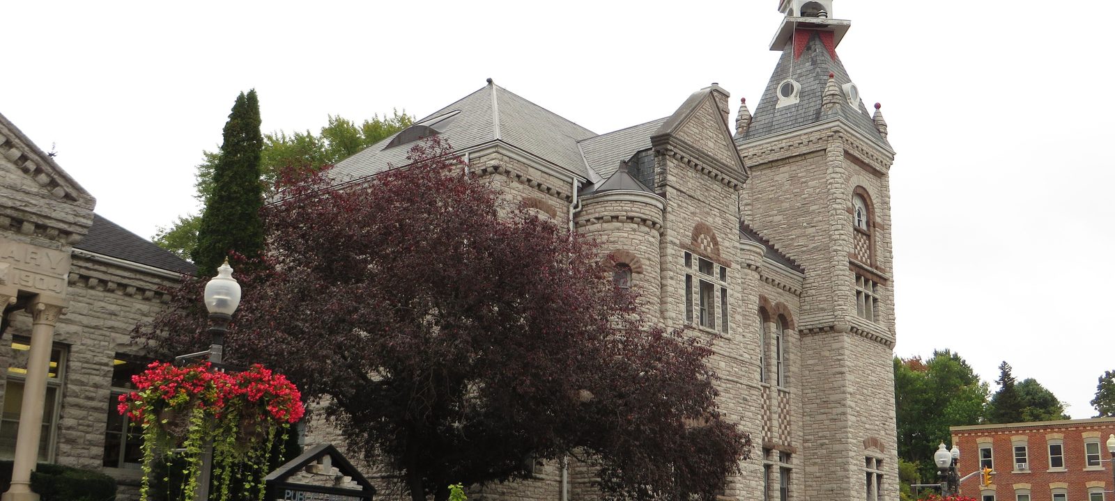
The St. Marys Town Hall, a grey limestone building with a clock tower and red roof, behind a tree with dark red leaves and flower baskets
The St. Marys Town Hall on Queen Street East.
Photo: Ken Lund from Reno, Nevada, USA, CC BY-SA 2.0

About St. Marys

St. Marys is a town of about 7,400 where Trout Creek joins the North Thames, southwest of Stratford and north of London. The river once tumbled over limestone ledges here, and the early settlement was called Little Falls. Thomas Ingersoll built the first mills in the early 1840s, the Grand Trunk Railway arrived in the late 1850s, and the town grew on milling, grain, and stone.

The stone is what you notice. Limestone was quarried right from the riverbed and its banks, and the churches, the downtown blocks, and many of the houses were built of it, which is why St. Marys calls itself the Stonetown. The town governs itself, separate from Perth County, and much of its life still happens downtown and along the water.

Below you’ll find the river and the Quarry, the Baseball Hall of Fame, the schools, the hospital, and how to get around, then a walk through the town: downtown, the south end by the Quarry, the east ward, and the west and north.

St. Marys in depth

The Stonetown

Limestone lay close to the surface along the river, and from the mid 1800s it was quarried along Water Street and used for nearly everything. You can see it in the downtown blocks on Queen Street, the town hall, the old water tower, and the library, built in 1904 and 1905 with a grant from the Andrew Carnegie Foundation.

The Grand Trunk Railway shaped the town too. The St. Marys Junction station, built in 1858, still stands in the north end, and the railway’s Sarnia Bridge, high over the Thames, is now part of the Grand Trunk Trail, a walkway with wide views over the town.

St. Marys in depth

The Quarry, the river, and the parks

In the south end, an old limestone quarry filled with water in the 1930s. The town now runs it as a swimming quarry, billed as the largest outdoor freshwater swimming pool in Canada, with picnic areas and a slide when the water allows.

Along the water, the Riverview Walkway follows the Thames south of downtown, and parks like the Flats, Cadzow Park, and Centennial Park are close to the centre of town. There is golf just past the east edge of town, too: St. Marys Golf and Country Club, a semi-private 18 on Queen Street East, has been there since 1932.

St. Marys in depth

The Canadian Baseball Hall of Fame

The Canadian Baseball Hall of Fame moved here from Toronto in 1994 and opened in 1998, on parkland in the south end. Its museum holds memorabilia from Canadian players and from the Blue Jays and the Expos, and there are ballfields beside it.

St. Marys in depth

Schools and the hospital

Public schools are run by the Avon Maitland District School Board: Little Falls Public School and St. Marys District Collegiate and Vocational Institute, the high school on Elizabeth Street, which also has elementary grades. Catholic schools are run by the Huron-Perth Catholic District School Board, with Holy Name of Mary School on Peel Street North. Boundaries change, so check the address with the school boards before you buy.

St. Marys Memorial Hospital is on Queen Street West.

St. Marys in depth

Getting around

Highway 7 runs through town and east to Stratford. VIA Rail stops at the station on James Street North, on the line between Toronto and Sarnia, and Perth County Connect runs a bus between London, St. Marys, and Stratford.

Queen Street and the Flats

Downtown and the river

Downtown sits on Queen Street, close to where Trout Creek meets the Thames, with the town hall, the library, and parkland along the water.

Map of Downtown and the river in St. Marys: the town boundary in this part are shaded, with the rivers, main roads, and parks. Each place in our guide is marked; choose one to read about it.Downtown
OpenStreetMap contributors

The stone downtown

Downtown and Queen Street

Downtown runs along Queen Street, with limestone commercial blocks, the town hall, and the library on Church Street North. Millennium Park and the Flats are along the river, and the Grand Trunk Trail crosses above them on the Sarnia Bridge.

Homes

Stone and brick homes from the 1800s on the streets around Queen Street.

Parks and green space

The Flats, Millennium Park, and Lind Park.

Day to day

Shops, restaurants, the museum, and the library are within a few blocks.

On the town map: Town of St. Marys.

The Quarry and the Hall of Fame

The south end

South of downtown, the river runs past the Riverview Walkway, the Quarry, and the Canadian Baseball Hall of Fame.

Map of The south end in St. Marys: the town boundary in this part are shaded, with the rivers, main roads, and parks. Each place in our guide is marked; choose one to read about it.South end
OpenStreetMap contributors

Swimming, baseball, and the riverside walk

The Quarry and the south end

South of downtown, the Riverview Walkway follows the Thames, Centennial Park and the Canadian Baseball Hall of Fame are close to the river, with the swimming quarry just beyond. The St. Marys Museum is on Church Street.

Homes

Older homes near the river and the museum, with more modern streets further south.

Parks and green space

Centennial Park, the Riverview Walkway, and the Quarry.

On the town map: Town of St. Marys.

The high school, the Pyramid, and the golf course

The east ward

East of the river, the town runs out past the high school and the Pyramid Recreation Centre toward the golf course at the edge of town.

Map of The east ward in St. Marys: the town boundary in this part are shaded, with the rivers, main roads, and parks. Each place in our guide is marked; choose one to read about it.East ward
OpenStreetMap contributors

Elizabeth Street and the Pyramid

The east ward

East of downtown, St. Marys District Collegiate and Vocational Institute is on Elizabeth Street, and the Pyramid Recreation Centre, Little Falls Public School, and Solis Fields sit together further east. East Ward Park and Southvale Park are here too, and St. Marys Golf and Country Club is just past the east edge of town on Queen Street East.

Homes

Homes of many ages, with family streets near the schools and the recreation centre.

Schools

St. Marys D.C.V.I. and Little Falls Public School, with Holy Name of Mary School on Peel Street North.

Parks and green space

East Ward Park, Southvale Park, Rotary Park, and Solis Fields.

On the town map: Town of St. Marys.

The hospital and the junction

The west and north

West of downtown are the hospital and the West Ward, and to the north the old railway junction.

Map of The west and north in St. Marys: the town boundary in this part are shaded, with the rivers, main roads, and parks. Each place in our guide is marked; choose one to read about it.West ward
OpenStreetMap contributors

The hospital and the junction

The west ward and the north end

West of the river, Queen Street West leads past St. Marys Memorial Hospital and West Ward Park. To the north, the old St. Marys Junction station, built in 1858 for the Grand Trunk, stands on Glass Street.

Homes

Older stone and brick homes near downtown, and homes of many ages further out.

Parks and green space

West Ward Park.

On the town map: Town of St. Marys.

Everyday drives

Real drives, day to day

Drives from this area to universities and colleges, major employers, hospitals, GO stations, and more, sorted nearest first. Times are by car without traffic.

See all 14 drives for this area on a map
Universities and collegesNearest about 22 minutes
  • From downtown St. Marys to University of Waterloo, Stratford School: about 22 minutesUniversity19 km by road, without traffic
  • From downtown St. Marys to Fanshawe College, London campus: about 41 minutesCollege37 km by road, without traffic
  • From downtown St. Marys to Western University: about 44 minutesUniversity41 km by road, without traffic
Major employersNearest about 38 minutes
  • From downtown St. Marys to General Dynamics Land Systems, London plant: about 38 minutes37 km by road, without traffic
  • From downtown St. Marys to Canada Life, London campus: about 47 minutes42 km by road, without traffic
  • From downtown St. Marys to Toyota, Woodstock plant: about 56 minutes55 km by road, without traffic
HospitalsNearest under 10 minutes
  • From downtown St. Marys to St. Marys Memorial Hospital: under 10 minutes1.0 km by road, without traffic
DowntownNearest about 22 minutes
  • From downtown St. Marys to downtown Stratford: about 22 minutes20 km by road, without traffic
  • From downtown St. Marys to downtown London: about 47 minutes42 km by road, without traffic
AirportsNearest about 38 minutes
  • From downtown St. Marys to London International Airport: about 38 minutes34 km by road, without traffic
Sports and entertainmentNearest under 10 minutes
  • From downtown St. Marys to the Canadian Baseball Hall of Fame: under 10 minutes1.2 km by road, without traffic
  • From downtown St. Marys to the Festival Theatre: about 24 minutes21 km by road, without traffic
GolfNearest under 10 minutes
  • From downtown St. Marys to St. Marys Golf and Country Club: under 10 minutes3.0 km by road, without traffic
Schools, markets, and main streetsNearest under 10 minutes
  • From downtown St. Marys to St. Marys D.C.V.I.: under 10 minutes1.0 km by road, without traffic

Selling

Selling a larger home in St. Marys

Selling a larger home or a property with some land in St. Marys? We’ll advise you to have the right checks done early, like the well, the septic system, and any outbuildings, then price it from recent sales nearby and plan the photos and timing with you.

Book a conversation

St. Marys

Questions people ask

Who can help me buy or sell a home in St. Marys?

We can help. We’re Tanner Hickey and Robin Hickey of RE/MAX Real Estate Centre Inc., Brokerage, based in Cambridge, with clients across Ontario. Call Tanner at 519-716-4806 or Robin at 519-240-8984, or book a conversation.

Why do people call St. Marys the Stonetown?

The stone is what you notice. Limestone from the riverbed built the churches, the downtown blocks, and many of the houses, which is why it calls itself the Stonetown. Much of life still happens downtown and along the water, where Trout Creek meets the North Thames.

How far is St. Marys from London?

Downtown London is under 50 minutes without traffic, and Stratford is just up the road to the northeast.

Who can help me sell a larger home in St. Marys?

We can. A house on some land brings its own questions, so we’ll advise you to have the well, the septic system, and any barns or outbuildings checked early, and we price it from recent sales nearby with our reasoning shown. Here’s how we handle rural properties, or ask for an opinion of value.

Book a conversation

Sources

Written from our work with clients here and the time we have spent getting to know the city, and checked against the sources below.

Each fact was checked against at least two sources. Neighbourhood names follow local usage, and the official areas each entry covers are listed under it. The streets named are examples rather than boundaries. Details such as school boundaries, zoning, and bus routes change, so please check anything important with the municipality, the transit agency, or the school board.