Peel Region

Caledon

A town of villages and hamlets spread across the Niagara Escarpment and the Oak Ridges Moraine, with the Credit River valley, horse country, and some of the best golf in Ontario.

8-minute read

Map of Caledon: every one of the settlement areas is shaded by the part of Caledon it belongs to in our guide, with the rivers, main roads, and parks. Choose one to open it in our guide.BoltonCaledon EastPalgraveAltonCaledonVillageBelfountainMono MillsInglewoodTerra CottaMayfield West
Ontario Municipal Boundaries, Town of Caledon, Nominatim, and OpenStreetMap contributors
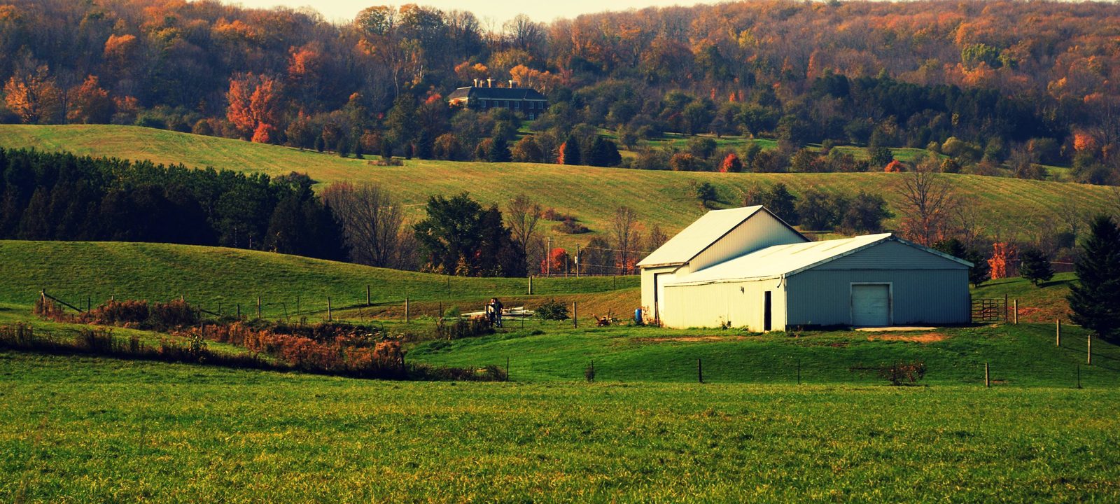
Rolling green fields in late afternoon light, a pale barn with a white roof, a wooden fence line, and wooded hills in autumn colour behind
Farm country in the Caledon hills.
Photo: Michael Gil from Toronto, ON, Canada, CC BY 2.0

About Caledon

Caledon covers the northern part of Peel Region, about 688 square kilometres of farms, forests, river valleys, and villages, the largest municipality in the GTA by area. About 76,600 people live here, many of them in Bolton, Caledon East, and Mayfield West, and the rest in villages and hamlets or out in the countryside.

The town was formed on January 1, 1974, from Albion and Caledon townships, the northern half of Chinguacousy Township, and the villages of Bolton and Caledon East. The Niagara Escarpment cuts across it on a diagonal, the Oak Ridges Moraine covers most of the northeast, and both are protected as part of the Greenbelt.

Below you’ll find the hills and valleys, the arts and horse country, schools, and how to get around, then a walk through Caledon’s communities. Bolton has a guide of its own.

Caledon in depth

The escarpment, the moraine, and the Credit

The Niagara Escarpment runs through the west of Caledon, and the Credit River cuts through it at the Forks of the Credit, where the provincial park has trails along the river and up the valley sides. Near Cheltenham, the Cheltenham Badlands show bare red Queenston shale, with a boardwalk and a short trail run by the Ontario Heritage Trust.

In Belfountain, Charles Mack bought land in 1908 and built a park with a dam and a small waterfall, a suspension bridge, and a fountain, and Credit Valley Conservation has run it as Belfountain Conservation Area since 1959. The Caledon Trailway, a 35 km gravel trail on an old railway line, runs from Terra Cotta through Inglewood and Caledon East to Palgrave.

Caledon in depth

Mills, arts, and horse country

In Alton, the Beaver Knitting Mill was built in 1881 on Shaw’s Creek and ran on water power until 1982. Restored, it’s now the Alton Mill Arts Centre, with studios and galleries. Out east, the Caledon Equestrian Park in Palgrave hosted equestrian events at the 2015 Pan Am Games.

For golf, Caledon has TPC Toronto at Osprey Valley near Alton, with three public 18s, the private Pulpit Club, and Caledon Country Club near Inglewood, with Glen Eagle and Caledon Woods in Bolton.

Caledon in depth

Schools

Public schools are run by the Peel District School Board, and Catholic schools by the Dufferin-Peel Catholic District School Board, with French-language schools as well. Public high schools include Humberview in Bolton and Mayfield Secondary School on Mayfield Road. Catholic high schools include St. Michael in Bolton and Robert F. Hall in Caledon East. Many of the villages have their own elementary schools, and students in the countryside are often bused, so it is worth checking an address with the board before you buy.

Caledon in depth

Getting around

Highway 10 runs north through Mayfield West and Caledon Village, Airport Road runs through Caledon East, and Highway 50 runs through Bolton. Highway 9 crosses the north end near Mono Mills, and Highway 427 now reaches Major Mackenzie Drive, south of Bolton. Most people here get around by car.

The Humber side

Bolton, Caledon East, and Palgrave

The east of the town, on the Humber side, with Bolton, Caledon East, and Palgrave.

Map of Bolton, Caledon East, and Palgrave in Caledon: the settlement areas in this part are shaded, with the rivers, main roads, and parks. Each place in our guide is marked; choose one to read about it.BoltonCaledon EastPalgrave
Ontario Municipal Boundaries, Town of Caledon, Nominatim, and OpenStreetMap contributors

The largest community

Bolton

Bolton, on the Humber River in the southeast of the town, is Caledon’s largest community, with a historic downtown on Queen Street and newer neighbourhoods around it. Our guide to Bolton has the full story.

Homes

Older homes near downtown and subdivisions of many decades.

Schools

Humberview and St. Michael high schools.

The Town’s settlement areas: Bolton.

The town hall

Caledon East

Caledon East, on Airport Road, is home to the town hall on Old Church Road and Robert F. Hall Catholic Secondary School. The Caledon Trailway passes through the village, with a trailhead and parking on Old Church Road.

Homes

Village homes and newer subdivisions.

Civic

Caledon Town Hall.

The Town’s settlement areas: Caledon East.

Horse country

Palgrave

Palgrave sits on Highway 50 in the northeast, on the Oak Ridges Moraine. The Caledon Equestrian Park is here, the Caledon Trailway ends at Palgrave Stationlands Park, and around the village the Palgrave Estate area has homes on large lots. Albion Hills Conservation Park, with 538 hectares of forest and mountain bike trails, is just to the south.

Homes

Village homes and estate homes on large lots.

Outdoors

The equestrian park, the trailway, and Albion Hills.

The Town’s settlement areas: Palgrave and Palgrave Estate.

Alton, Caledon Village, Belfountain, and Mono Mills

The hills

The northwest, up on the escarpment and the moraine, with Alton, Caledon Village, Belfountain, and Mono Mills.

Map of The hills in Caledon: the settlement areas in this part are shaded, with the rivers, main roads, and parks. Each place in our guide is marked; choose one to read about it.AltonCaledon VillageBelfountainMono Mills
Ontario Municipal Boundaries, Town of Caledon, Nominatim, and OpenStreetMap contributors

The mill on Shaw’s Creek

Alton

Alton is a mill village on Shaw’s Creek in the west of the town, home to the Alton Mill Arts Centre. TPC Toronto at Osprey Valley is just outside the village.

Homes

Village homes and country properties.

Arts

The Alton Mill Arts Centre.

The Town’s settlement areas: Alton.

On Highway 10

Caledon Village

Caledon Village sits on Highway 10 at Charleston Sideroad, with the Forks of the Credit a short drive south and farm country all around.

Homes

Village homes and country properties.

Outdoors

The Forks of the Credit, to the south.

The Town’s settlement areas: Caledon Village.

The Credit River gorge

Belfountain

Belfountain is above the Credit River in the escarpment, around the conservation area that began as Charles Mack’s park, with its dam, waterfall, and suspension bridge.

Homes

Village homes and houses on wooded lots.

Outdoors

Belfountain Conservation Area and the Bruce Trail nearby.

The Town’s settlement areas: Belfountain.

The north end

Mono Mills

Mono Mills is a small community at the north end of the town, where Airport Road meets Highway 9, among the hills of the moraine.

Homes

Country homes and village lots.

Getting around

Airport Road and Highway 9.

The Town’s settlement areas: Mono Mills.

Inglewood, Cheltenham, and Terra Cotta

The Credit valley

The Credit River villages at the foot of the escarpment: Inglewood, Cheltenham, and Terra Cotta.

Map of The Credit valley in Caledon: the settlement areas in this part are shaded, with the rivers, main roads, and parks. Each place in our guide is marked; choose one to read about it.InglewoodTerra Cotta
Ontario Municipal Boundaries, Town of Caledon, Nominatim, and OpenStreetMap contributors

Credit River villages

Inglewood and Cheltenham

Inglewood and Cheltenham sit along the Credit River at the foot of the escarpment. The Caledon Trailway passes through Inglewood, with parking on McLaughlin Road, and the Cheltenham Badlands are on Olde Base Line Road, close to both. Caledon Country Club is just outside Inglewood.

Homes

Village homes and country properties.

Outdoors

The Caledon Trailway and the Cheltenham Badlands.

The Town’s settlement areas: Inglewood and Cheltenham.

Red clay and the Credit

Terra Cotta

Terra Cotta takes its name from the red clay and the brickmaking that once went on here. It’s the southern end of the Caledon Trailway, and Terra Cotta Conservation Area, run by Credit Valley Conservation since 1959, is close by.

Homes

Village homes and country properties.

Outdoors

Terra Cotta Conservation Area and the trailway.

The Town’s settlement areas: Terra Cotta.

The newest neighbourhoods

Mayfield West

The south of the town along Highway 10 and Mayfield Road, where most of Caledon’s new homes are being built.

Map of Mayfield West in Caledon: the settlement areas in this part are shaded, with the rivers, main roads, and parks. Each place in our guide is marked; choose one to read about it.Mayfield West
Ontario Municipal Boundaries, Town of Caledon, Nominatim, and OpenStreetMap contributors

New neighbourhoods by Highway 10

Mayfield West

Mayfield West is where Caledon is growing fastest, on new streets north of Mayfield Road around Highway 10, with Mayfield Secondary School on Mayfield Road. The town’s plan adds another stage west of Highway 10, with room for about 7,000 more residents.

Homes

Newer detached homes and townhouses.

School

Mayfield Secondary School.

The Town’s settlement areas: Mayfield West.

Everyday drives

Real drives, day to day

Drives from this area to universities and colleges, major employers, hospitals, GO stations, and more, sorted nearest first. Times are by car without traffic.

See all 19 drives for this area on a map
Universities and collegesNearest about 34 minutes
  • From Caledon East to Humber College, North campus: about 34 minutesCollege30 km by road, without traffic
  • From Caledon East to Sheridan College, Mississauga campus: about 38 minutesCollege42 km by road, without traffic
  • From Caledon East to York University, Keele campus: about 41 minutesUniversity40 km by road, without traffic
  • From Caledon East to University of Toronto, Mississauga campus: about 48 minutesUniversity52 km by road, without traffic
Major employersNearest about 42 minutes
  • From Caledon East to Honda, Alliston plant: about 42 minutes40 km by road, without traffic
  • From Caledon East to Ford, Oakville Assembly Complex: about 49 minutes59 km by road, without traffic
  • From Caledon East to First Canadian Place, Financial District: about 55 minutes60 km by road, without traffic
GO stations and Union StationNearest about 20 minutes
  • From Mayfield West to Georgetown GO Station: about 20 minutes16 km by road, without traffic
AirportsNearest about 29 minutes
  • From Mayfield West to Pearson Airport: about 29 minutes27 km by road, without traffic
Parks and outdoorsNearest about 11 minutes
  • From Caledon East to Albion Hills Conservation Park: about 11 minutes7.2 km by road, without traffic
  • From Caledon Village to Belfountain Conservation Area: about 14 minutes11 km by road, without traffic
GolfNearest about 13 minutes
  • From Caledon East to Caledon Woods Golf Club: about 13 minutes11 km by road, without traffic
Schools, markets, and main streetsNearest about 20 minutes
  • From Caledon East to Humberview Secondary School: about 20 minutes16 km by road, without traffic

Selling

Selling a larger home in Caledon

Selling a larger home or a property with some land in Caledon? We’ll advise you to have the right checks done early, like the well, the septic system, and any outbuildings, then price it from recent sales nearby and plan the photos and timing with you.

Book a conversation

Caledon

Questions people ask

Who can help me buy or sell a home in Caledon?

That would be us. We’re Tanner Hickey and Robin Hickey of RE/MAX Real Estate Centre Inc., Brokerage, based in Cambridge, with clients across Ontario. Call Tanner at 519-716-4806 or Robin at 519-240-8984, or book a conversation.

Is Caledon really that rural?

It’s a lot of countryside, the largest municipality in the GTA by area, with farms, forests, river valleys, and villages. The Niagara Escarpment cuts across on a diagonal and the Oak Ridges Moraine covers much of the northeast, both protected as part of the Greenbelt. Bolton, Caledon East, and Mayfield West are where most people live.

How far is Caledon from Pearson?

From the middle of the town, about 40 minutes without traffic, and Union Station is closer to an hour.

Who can help me sell a larger home in Caledon?

We can. A house on some land brings its own questions, so we’ll advise you to have the well, the septic system, and any barns or outbuildings checked early, and we price it from recent sales nearby with our reasoning shown. Here’s how we handle rural properties, or ask for an opinion of value.

Book a conversation

Sources

Written from our work with clients here and the time we have spent getting to know the city, and checked against the sources below.

Each fact was checked against at least two sources. Neighbourhood names follow local usage, and the official areas each entry covers are listed under it. The streets named are examples rather than boundaries. Details such as school boundaries, zoning, and bus routes change, so please check anything important with the municipality, the transit agency, or the school board.