City of Hamilton

Stoney Creek

Hamilton’s east end, from the lake and the fruit farms of Winona to the Old Town under the escarpment and the newer streets and farmland on the Mountain above it.

8-minute read

Map of Stoney Creek: every one of the neighbourhoods is shaded by the part of Stoney Creek it belongs to in our guide, with the rivers, main roads, and parks. Choose one to open it in our guide.Old TownLakeshoreFruitlandWinonaUpperStoney CreekVinemount
City of Hamilton Open Data (neighbourhoods) and OpenStreetMap contributors
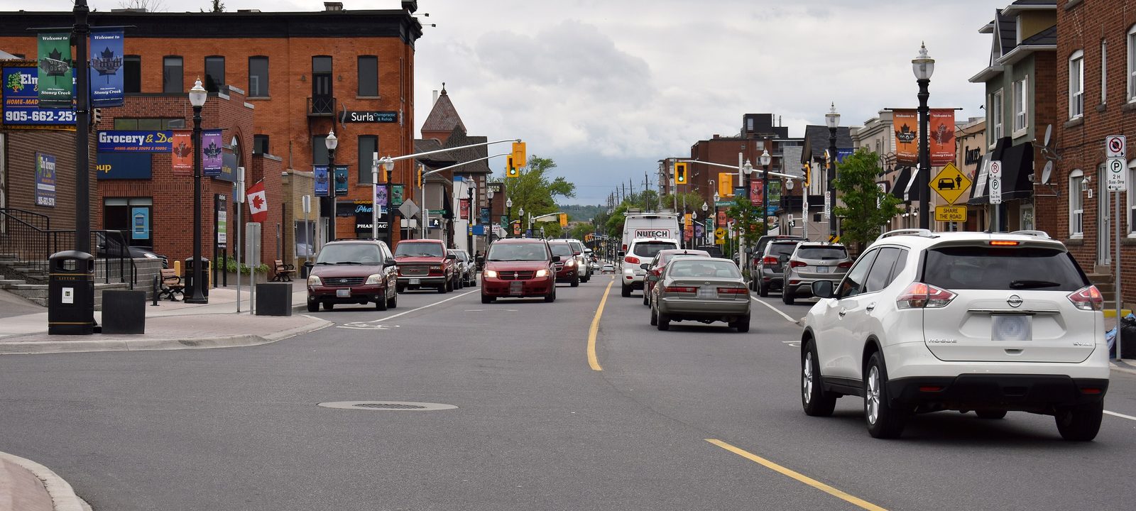
King Street in downtown Stoney Creek, with two and three-storey brick buildings, street lamps, and cars on the road under a cloudy sky
King Street in the Old Town.
Photo: Joey Coleman, CC BY-SA 2.0

About Stoney Creek

Stoney Creek is the east end of Hamilton, about ten kilometres from downtown, running along Lake Ontario toward Grimsby. It was a town from 1974 and a city from 1984, and in 2001 it joined Hamilton, Ancaster, Dundas, Flamborough, and Glanbrook to form today’s City of Hamilton. It takes its name from the creek that runs from the Devil’s Punchbowl, on the escarpment, down to the lake.

The Niagara Escarpment splits it in two. Below it are the Old Town on King Street, the battlefield, the lakeshore, and Fruitland and Winona, where fruit farms once ran right down to the water. Above it, on the Mountain, are the newer neighbourhoods of Upper Stoney Creek and a wide stretch of farmland with villages like Vinemount and Tapleytown.

Below you’ll find the battlefield, the escarpment and the lake, the fruit belt, the schools, and how to get around, then a walk through Stoney Creek, using the City’s own neighbourhood names. Our guide to Hamilton covers the rest of the city.

Stoney Creek in depth

The battlefield

On the night of June 6, 1813, British regulars and local militia surprised an American army camped here, a turning point in the War of 1812 in this part of Upper Canada. The ground is now Battlefield House Museum and Park, a National Historic Site run by the City, with Battlefield House itself and the Battlefield Monument, unveiled on the battle’s hundredth anniversary in 1913.

Up on Ridge Road, along the brow of the escarpment, the Erland Lee Museum is the farmhouse where Janet and Erland Lee drafted the constitution of the first Women’s Institute in 1897, an idea that spread around the world.

Stoney Creek in depth

The escarpment and the lake

The creek drops over the escarpment at the Devil’s Punchbowl, a deep bowl of layered rock with a waterfall and a lookout over the lake, and side trails of the Bruce Trail lead to it and to the battlefield. Up on the Mountain, the Eramosa Karst Conservation Area has caves, sinkholes, and trails.

On the lake, Fifty Point Conservation Area has a beach, camping, and a small craft harbour. For golf, Pros Golf Centre, a public nine with a driving range, is on Green Mountain Road in Upper Stoney Creek, and Scenic Woods is a few minutes south in Hannon.

Stoney Creek in depth

The fruit belt

The strip between the escarpment and the lake has a mild climate for this part of Ontario, and Stoney Creek was known for its orchards for generations. Fruitland and Winona still carry the names. The Winona Peach Festival began in 1967, as a Centennial project, and since 1977 it has grown into a three day festival in Winona Park each August.

Stoney Creek in depth

Schools

Public schools are run by the Hamilton-Wentworth District School Board, with Saltfleet High School on the Mountain and Orchard Park Secondary School in Fruitland. Catholic schools are run by the Hamilton-Wentworth Catholic District School Board, with St. John Henry Newman Catholic Secondary School on Gray Road. Each neighbourhood below lists its elementary schools. Boundaries change, so check the address with the school boards before you buy.

Stoney Creek in depth

Getting around

The QEW runs along the lower city toward Niagara and Toronto, and the Red Hill Valley Parkway and the Lincoln Alexander Parkway connect Stoney Creek to the rest of Hamilton. Confederation GO, at Centennial Parkway and the QEW, opened in 2025 on the Lakeshore West line, and HSR buses serve the built up areas.

Below the escarpment

The Old Town and the lakeshore

The Old Town on King Street, the battlefield, and the neighbourhoods that spread toward the lake in the 1970s and 1980s.

Map of The Old Town and the lakeshore in Stoney Creek: the neighbourhoods in this part are shaded, with the rivers, main roads, and parks. Each place in our guide is marked; choose one to read about it.Old TownLakeshore
City of Hamilton Open Data (neighbourhoods) and OpenStreetMap contributors

King Street and the battlefield

The Old Town and Battlefield

The Old Town grew up along King Street below the escarpment, where the creek comes down to the plain. Battlefield House and its park are on King Street West, and the Devil’s Punchbowl is just up the hill. The City maps this area as Stoney Creek, Battlefield, Corman, and Highway Valley.

Homes

Older homes near King Street, with 1970s and 1980s streets around them.

Schools

St. John Henry Newman Catholic Secondary School is on Gray Road, with Collegiate Avenue, St. Clare of Assisi, St. David, St. Francis Xavier, and St. Martin of Tours among the elementary schools.

History

Battlefield House Museum and Park, and the Battlefield Monument.

The City of Hamilton’s neighbourhoods: Stoney Creek, Battlefield, Corman (Stoney Creek), and Highway Valley.

Toward the lake and the QEW

The lakeshore

North of the Old Town, homes spread toward the lake in the 1970s and 1980s, on both sides of the QEW, with industrial land along the highway. The City maps it as Lakeshore, Poplar Park, Guernsey, Eastdale, and South Meadow.

Homes

Mostly detached homes and townhouses from the 1970s and 1980s, with some newer homes near the water.

Schools

Eastdale and South Meadow are among the elementary schools.

The City of Hamilton’s neighbourhoods: Lakeshore, Poplar Park, Guernsey, Eastdale, South Meadow, and Industrial, lower Stoney Creek.

The fruit belt

Fruitland and Winona

East of the Old Town, Fruitland and Winona run along the lake toward Grimsby, with newer streets among the old farms.

Map of Fruitland and Winona in Stoney Creek: the neighbourhoods in this part are shaded, with the rivers, main roads, and parks. Each place in our guide is marked; choose one to read about it.FruitlandWinona
City of Hamilton Open Data (neighbourhoods) and OpenStreetMap contributors

Old orchards and new streets

Fruitland

Fruitland runs along the lake east of the Old Town. Orchards have given way to newer streets here, with industrial land along the QEW. The City maps it as Fruitland, Trillium, Bayview, Westmeria, and Dewitt, and Orchard Park Secondary School is on DeWitt Road.

Homes

Newer detached homes and townhouses, with older farmhouses here and there.

Schools

Orchard Park Secondary School, with Immaculate Heart of Mary, Our Lady of Peace, and St. Gabriel among the elementary schools.

The City of Hamilton’s neighbourhoods: Fruitland, Industrial, Fruitland, Trillium, Bayview, Westmeria, and Dewitt.

The peach festival and the lake

Winona and Fifty Point

Winona is the eastern end of Stoney Creek, next to Grimsby. Winona Park hosts the peach festival every August, and Fifty Point Conservation Area is on the lake, with its beach and harbour.

Homes

Newer subdivisions, with older homes and farms nearby.

Schools

Winona Elementary School.

Parks and green space

Fifty Point Conservation Area and Winona Park.

The City of Hamilton’s neighbourhoods: Winona North, Winona South, and Fifty Point.

On the Mountain

Upper Stoney Creek

Above the escarpment, neighbourhoods built mostly in the 1990s and 2000s.

Map of Upper Stoney Creek in Stoney Creek: the neighbourhoods in this part are shaded, with the rivers, main roads, and parks. Each place in our guide is marked; choose one to read about it.Upper Stoney Creek
City of Hamilton Open Data (neighbourhoods) and OpenStreetMap contributors

Newer neighbourhoods on the Mountain

Upper Stoney Creek

Above the escarpment, homes spread across this part of Stoney Creek in the 1990s and 2000s. The City maps Albion, Felker, Highland, Nash, Trinity, and Valley Park here. The Eramosa Karst Conservation Area is on the west side, and Saltfleet High School is on Highland Road West.

Homes

Mostly detached homes and townhouses from the 1990s on.

Schools

Saltfleet High School, with Billy Green, Gatestone, Janet Lee, Mount Albion, St. James the Apostle, St. Mark, and St. Paul among the elementary schools.

Parks and green space

The Eramosa Karst Conservation Area and Valley Park.

The City of Hamilton’s neighbourhoods: Albion, Felker, Highland, Nash North, Nash South, Trinity (Stoney Creek), and Valley Park.

Vinemount and Tapleytown

The Mountain countryside

Most of Stoney Creek is still farmland, and much of it’s up here, with small villages along the back roads.

Map of The Mountain countryside in Stoney Creek: the neighbourhoods in this part are shaded, with the rivers, main roads, and parks. Each place in our guide is marked; choose one to read about it.Vinemount
City of Hamilton Open Data (neighbourhoods) and OpenStreetMap contributors

Farmland above the escarpment

Vinemount and Tapleytown

Most of Stoney Creek is still farmland, and much of it’s up here, with villages like Vinemount and Tapleytown along the back roads. The City maps it all as the East Mountain Area.

Homes

Country properties, farms, and village homes.

Schools

Tapleytown and Our Lady of the Assumption are the elementary schools here.

The City of Hamilton’s neighbourhoods: East Mountain Area.

Everyday drives

Real drives, day to day

Drives from this area to universities and colleges, major employers, hospitals, GO stations, and more, sorted nearest first. Times are by car without traffic.

See all 17 drives for this area on a map
Universities and collegesNearest about 22 minutes
  • From Stoney Creek to Mohawk College, Fennell campus: about 22 minutesCollege18 km by road, without traffic
  • From Upper Stoney Creek to McMaster University: about 27 minutesUniversity17 km by road, without traffic
  • From Stoney Creek to Sheridan College, Trafalgar campus in Oakville: about 31 minutesCollege37 km by road, without traffic
  • From Stoney Creek to University of Toronto, Mississauga campus: about 41 minutesUniversity47 km by road, without traffic
Major employersNearest about 14 minutes
  • From Stoney Creek to ArcelorMittal Dofasco, Hamilton steel plant: about 14 minutes9.1 km by road, without traffic
  • From Stoney Creek to Ford, Oakville Assembly Complex: about 31 minutes38 km by road, without traffic
HospitalsNearest about 17 minutes
  • From Upper Stoney Creek to Juravinski Hospital: about 17 minutes10 km by road, without traffic
DowntownNearest about 18 minutes
  • From Stoney Creek to downtown Hamilton: about 18 minutes13 km by road, without traffic
GO stations and Union StationNearest about 6 minutes
  • From Stoney Creek to Confederation GO Station: about 6 minutes3.9 km by road, without traffic
Highway on-rampsNearest about 7 minutes
  • From Stoney Creek to the QEW at Centennial Parkway: about 7 minutes4.6 km by road, without traffic
AirportsNearest about 28 minutes
  • From Upper Stoney Creek to John C. Munro Hamilton International Airport: about 28 minutes24 km by road, without traffic
Parks and outdoorsNearest about 18 minutes
  • From Stoney Creek to Fifty Point Conservation Area: about 18 minutes13 km by road, without traffic
GolfNearest about 19 minutes
  • From Upper Stoney Creek to Scenic Woods Golf Club: about 19 minutes14 km by road, without traffic
Schools, markets, and main streetsNearest about 6 minutes
  • From Stoney Creek to Orchard Park Secondary School: about 6 minutes4.3 km by road, without traffic

Selling

Selling a larger home in Stoney Creek

Selling a larger home in Stoney Creek takes a careful price, good preparation, and strong photography. You deal with the two of us directly, from the first visit to closing day, and your plans stay confidential until you’re ready.

Book a conversation

Stoney Creek

Questions people ask

Who can help me buy or sell a home in Stoney Creek?

We can. We’re Tanner Hickey and Robin Hickey of RE/MAX Real Estate Centre Inc., Brokerage, based in Cambridge, with clients across Ontario. You get both of us, start to finish. Call Tanner at 519-716-4806 or Robin at 519-240-8984, or book a conversation.

What’s it like to live in Stoney Creek?

Below the escarpment you’ve got the Old Town on King Street, the battlefield, the lakeshore, and Fruitland and Winona, where fruit farms once ran down to the water. Up on the Mountain are the newer neighbourhoods of Upper Stoney Creek and wide farmland.

How far is Stoney Creek from downtown Hamilton?

About 15 minutes without traffic. Union Station in Toronto is just under an hour.

Who can help me sell a larger home in Stoney Creek?

We’d be glad to. Robin has been selling real estate since 1985 and Tanner since 2018, and with a larger home that experience shows in the details: a careful price, a house that shows well, and privacy if you’d rather the neighbours not know yet. Here’s how we sell family and larger homes.

Book a conversation

Sources

Written from our work with clients here and the time we have spent getting to know the city, and checked against the sources below.

Each fact was checked against at least two sources. Neighbourhood names follow local usage, and the official areas each entry covers are listed under it. The streets named are examples rather than boundaries. Details such as school boundaries, zoning, and bus routes change, so please check anything important with the municipality, the transit agency, or the school board.