Niagara Region

Grimsby

A lakeside town between the water and the Niagara Escarpment, at the west end of Niagara’s fruit and wine country, with a new hospital and a GO station on the way.

6-minute read

Map of Grimsby: every one of the town boundary is shaded by the part of Grimsby it belongs to in our guide, with the rivers, main roads, and parks. Choose one to open it in our guide.DowntownGrimsby BeachEast endEscarpment
Ontario Municipal Boundaries, Nominatim, and OpenStreetMap contributors
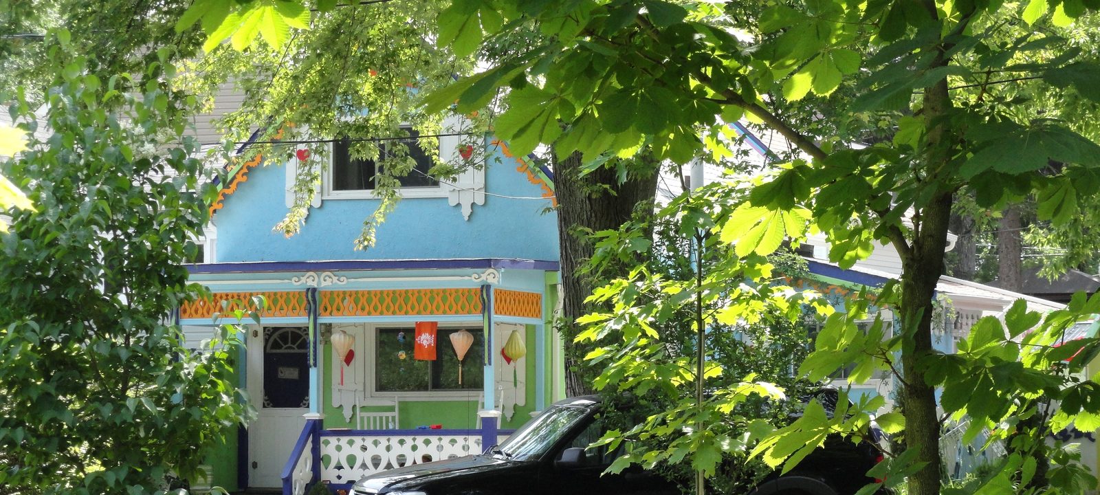
A pale blue painted cottage with ornate white and orange trim and a porch, partly hidden behind trees and a parked car
One of the painted cottages at Grimsby Beach.
Photo: ontario-travel-secrets.com from Canada, CC BY 2.0

About Grimsby

Grimsby sits on the south shore of Lake Ontario, at the eastern edge of the Hamilton area and the western edge of Niagara. Most of the town lies on the narrow strip between the lake and the Niagara Escarpment, with the Bruce Trail running along the top of the cliffs.

Loyalists settled here in the late 1780s, at a spot first called the Forty, after the creek that runs through town. The name Grimsby came in 1816, the village was incorporated in 1876, and it became a town in 1922. Orchards once covered much of the land between the lake and the escarpment; most gave way to homes in the decades after the 1950s, and Grimsby is now a starting point for Niagara’s wine country.

Below you’ll find the lake and the escarpment, the town’s camp meeting past, the new hospital and the GO station, the schools, and how to get around, then a walk through Grimsby: downtown, Grimsby Beach, the east end, and up the escarpment.

Grimsby in depth

The escarpment and the lake

The Niagara Escarpment rises right behind downtown. Beamer Memorial Conservation Area, run by the Niagara Peninsula Conservation Authority, has lookouts over the town and the lake and trails through the Forty Mile Creek valley, and every spring the Niagara Peninsula Hawkwatch counts migrating hawks from its tower. The Bruce Trail runs along the top of the cliffs.

On the lake, there are small parks and beaches along the shore. For golf, there is no course inside the town, but Twenty Valley is a short drive east in Vineland and Scenic Woods is west on the Mountain in Hannon.

Grimsby in depth

Grimsby Park and the painted cottages

In 1859, a Methodist camp meeting began at Grimsby Park, by the lake, and it grew into one of the first summer assemblies of its kind in Canada, with hotels, a temple, and rows of colourful wooden cottages. Later the grounds became an amusement park, which faded after the Depression began in the 1930s. Fires and redevelopment took most of the old buildings, but a number of the painted cottages still stand at Grimsby Beach.

Grimsby in depth

The new hospital and the GO station

The new West Lincoln Memorial Hospital opened on November 24, 2025, on Main Street East, run by Hamilton Health Sciences. It serves Grimsby and the towns around it.

Construction of Grimsby GO station, near Casablanca Boulevard, began in 2026, and the province expects it to open in the second half of 2027 on the Lakeshore West line. Until then, VIA Rail’s Toronto to New York train stops at the Grimsby station on Ontario Street.

Grimsby in depth

Schools

Public schools are run by the District School Board of Niagara, with Central, Grand Avenue, Lakeview, Nelles, Park, and Smith among the elementary schools. Public high school students go to West Niagara Secondary School, just east in Beamsville. Catholic schools are run by the Niagara Catholic District School Board: Our Lady of Fatima and St. Joseph, and Blessed Trinity Catholic Secondary School on Livingston Avenue. Boundaries change, so check the address with the school boards before you buy.

Grimsby in depth

Getting around

The QEW runs through the middle of town, with interchanges at Casablanca Boulevard, at Christie Street, Ontario Street, and Maple Avenue, and at Bartlett Avenue. Hamilton is to the west and St. Catharines to the east, both along the QEW.

Main Street and the Forty

Downtown

The old centre on Main Street, close to where Forty Mile Creek comes down from the escarpment, with the museum, the library, and the art gallery.

Map of Downtown in Grimsby: the town boundary in this part are shaded, with the rivers, main roads, and parks. Each place in our guide is marked; choose one to read about it.Downtown
Ontario Municipal Boundaries, Nominatim, and OpenStreetMap contributors

Main Street

Downtown Grimsby

Downtown runs along Main Street, below the escarpment. The Grimsby Museum is on Murray Street, the library and the Grimsby Public Art Gallery are close by, and St. Andrew’s Anglican Church is on Main Street West.

Homes

Older homes on the streets around Main Street, with some newer infill.

Day to day

Shops, restaurants, the library, and the art gallery are within a few blocks.

On the town map: Town of Grimsby.

The cottages and the shore

Grimsby Beach and the lake

North of the QEW, toward the lake, with the old Grimsby Park grounds, the Peach King Centre, and newer homes and condos near the water.

Map of Grimsby Beach and the lake in Grimsby: the town boundary in this part are shaded, with the rivers, main roads, and parks. Each place in our guide is marked; choose one to read about it.Grimsby Beach
Ontario Municipal Boundaries, Nominatim, and OpenStreetMap contributors

The painted cottages

Grimsby Beach

Grimsby Beach is the old Grimsby Park, on the lake west of the town centre, where some of the painted cottages from the camp meeting days still stand among newer homes. The Peach King Centre, the town arena, is nearby, and newer condos have gone up close to the water and the QEW.

Homes

Painted cottages and older homes, newer houses, and condos near the lake.

Recreation

The Peach King Centre.

On the town map: Town of Grimsby.

Toward Beamsville

The east end

East of downtown along Main Street East, with the new hospital and streets of homes from many decades.

Map of The east end in Grimsby: the town boundary in this part are shaded, with the rivers, main roads, and parks. Each place in our guide is marked; choose one to read about it.East end
Ontario Municipal Boundaries, Nominatim, and OpenStreetMap contributors

The hospital and Main Street East

The east end

East of downtown, Main Street East leads past the new West Lincoln Memorial Hospital toward Beamsville, with streets of homes from many decades on both sides.

Homes

Homes from many decades, with newer streets toward the town line.

Health

West Lincoln Memorial Hospital.

On the town map: Town of Grimsby.

Beamer and the Bruce Trail

The escarpment

Up the escarpment, the lookouts and trails of Beamer Memorial, and farmland beyond.

Map of The escarpment in Grimsby: the town boundary in this part are shaded, with the rivers, main roads, and parks. Each place in our guide is marked; choose one to read about it.Escarpment
Ontario Municipal Boundaries, Nominatim, and OpenStreetMap contributors

Lookouts, trails, and farms

Up the escarpment

Above the town, Beamer Memorial Conservation Area looks out over Grimsby and the lake, the Bruce Trail follows the brow, and farmland stretches south toward the town line.

Homes

Country properties and homes on larger lots.

Parks and green space

Beamer Memorial Conservation Area and the Bruce Trail.

On the town map: Town of Grimsby.

Everyday drives

Real drives, day to day

Drives from this area to universities and colleges, major employers, hospitals, GO stations, and more, sorted nearest first. Times are by car without traffic.

See all 14 drives for this area on a map
Universities and collegesNearest about 27 minutes
  • From downtown Grimsby to Brock University: about 27 minutesUniversity35 km by road, without traffic
  • From downtown Grimsby to Mohawk College, Fennell campus: about 34 minutesCollege37 km by road, without traffic
  • From downtown Grimsby to McMaster University: about 38 minutesUniversity45 km by road, without traffic
  • From downtown Grimsby to Sheridan College, Trafalgar campus in Oakville: about 38 minutesCollege50 km by road, without traffic
Major employersNearest about 20 minutes
  • From downtown Grimsby to ArcelorMittal Dofasco, Hamilton steel plant: about 20 minutes23 km by road, without traffic
  • From downtown Grimsby to Ford, Oakville Assembly Complex: about 38 minutes51 km by road, without traffic
HospitalsNearest under 10 minutes
  • From downtown Grimsby to West Lincoln Memorial Hospital: under 10 minutes1.9 km by road, without traffic
GO stations and Union StationNearest about 16 minutes
  • From downtown Grimsby to Confederation GO Station: about 16 minutes18 km by road, without traffic
Highway on-rampsNearest under 10 minutes
  • From downtown Grimsby to the QEW at Christie Street: under 10 minutes1.3 km by road, without traffic
AirportsNearest about 40 minutes
  • From downtown Grimsby to John C. Munro Hamilton International Airport: about 40 minutes42 km by road, without traffic
Parks and outdoorsNearest about 5 minutes
  • From downtown Grimsby to Grimsby Beach: about 5 minutes3.6 km by road, without traffic
  • From downtown Grimsby to Fifty Point Conservation Area: about 14 minutes9.0 km by road, without traffic
GolfNearest about 24 minutes
  • From downtown Grimsby to Twenty Valley Golf and Country Club: about 24 minutes23 km by road, without traffic

Selling

Selling a larger home in Grimsby

Every larger home in Grimsby is a little different, so we price it from recent sales nearby and what’s for sale now, not a formula, and we show you our reasoning. Then we prepare the house to show well and agree with you in advance how public the marketing should be.

Book a conversation

Grimsby

Questions people ask

Who can help me buy or sell a home in Grimsby?

Robin and I are glad to help. We’re Tanner Hickey and Robin Hickey, Sales Representatives with RE/MAX Real Estate Centre Inc., Brokerage, based in Cambridge and working with clients across Ontario. Call Tanner at 519-716-4806 or Robin at 519-240-8984, or book a conversation.

What’s Grimsby like, between the lake and the escarpment?

Most of the town sits on a narrow strip between Lake Ontario and the escarpment, with the Bruce Trail running along the cliffs. Orchards once covered much of that land, and today Grimsby is a starting point for Niagara’s wine country.

How far is Grimsby from Hamilton and Toronto?

Downtown Hamilton is about half an hour without traffic, and Union Station is about an hour.

Who can help me sell a larger home in Grimsby?

That’s us. We’ll walk through the house with you, tell you what’s worth doing before you list and what you can leave alone, and plan the photos and the timing around your next move. To see where your home stands, ask for an opinion of value.

Book a conversation

Sources

Written from our work with clients here and the time we have spent getting to know the city, and checked against the sources below.

Each fact was checked against at least two sources. Neighbourhood names follow local usage, and the official areas each entry covers are listed under it. The streets named are examples rather than boundaries. Details such as school boundaries, zoning, and bus routes change, so please check anything important with the municipality, the transit agency, or the school board.