Centre Wellington, Wellington County

Elora

A stone village where Irvine Creek meets the Grand River, with a gorge at the edge of town, a summer music festival, and a downtown built from the same limestone as the cliffs.

7-minute read

Map of Elora: every one of the urban centre is shaded by the part of Elora it belongs to in our guide, with the rivers, main roads, and parks. Choose one to open it in our guide.DowntownSalemSouth sideEast end
County of Wellington (urban centre boundary) and OpenStreetMap contributors
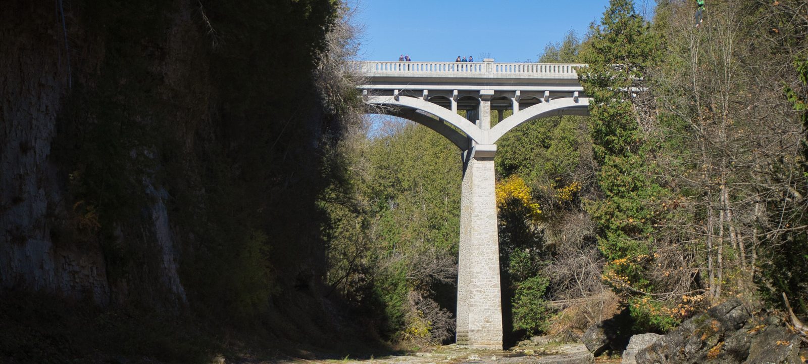
A white concrete arch bridge on a tall stone pier high above Irvine Creek, between steep limestone walls and autumn trees
The David Street Bridge over Irvine Creek.
Photo: Chicken4War, CC BY-SA 4.0

About Elora

Elora sits where Irvine Creek runs into the Grand River, about 20 kilometres north of Guelph. Captain William Gilkison founded the village in 1832 and named it after his brother’s ship, the Elora, which took its name from the Ellora caves in India. The river powered mills and distilleries through the 1800s, and the village was incorporated in 1858.

Since 1999, Elora has been part of the Township of Centre Wellington, along with Fergus and the countryside around them. It still feels like its own place. The downtown is built of local limestone, the Grand drops into a gorge right beside Mill Street, and on a summer weekend you will hear music from the festival and see tubers floating down the river.

Below you’ll find the gorge and the Quarry, the village’s story, the festival and the cinema, the schools, the hospital, and how to get around, then a walk through Elora: downtown, Salem across the creek, the south side of the river, and the east end.

Elora in depth

The gorge and the Quarry

Just below downtown, the Grand River drops into a narrow limestone gorge with tall cliffs on both sides. The Grand River Conservation Authority runs the Elora Gorge Conservation Area at the edge of town, with riverside trails behind safety barriers, lookouts over the water, campsites, and a stretch of river where people tube and kayak through the rapids in summer.

At the east end of the village, the Elora Quarry is an old limestone quarry that the conservation authority now runs as a swimming spot, with a beach and stone walls around the water. Both are seasonal and get busy on hot days, so passes are worth booking ahead. For golf, Fergus Golf Club is just north of Fergus and Wildwinds Golf Links is a little further east.

Elora in depth

A stone village on the Grand

The Elora Mill is where it started. A mill has stood beside the falls since 1832, and over the years the five storey stone building housed a grist mill, a sawmill, and a distillery. After a long renovation, it reopened in 2018 as the Elora Mill Hotel and Spa.

Around it, the old downtown on Mill, Metcalfe, and Geddes Streets is mostly limestone and brick from the 1800s. Many of the buildings went up when the village was a busy market town for the farms around it, and a good number now hold shops, galleries, and restaurants.

Elora in depth

Music, film, and the museum

The Elora Festival began in 1979, and its choir, the Elora Singers, grew out of it. Every July and August, the festival fills churches and the Gambrel Barn with concerts. The Gorge Cinema on Mill Street opened in 1974 and is known as the oldest continuously running repertory cinema in Canada.

Halfway between Elora and Fergus, the Wellington County Museum and Archives is in the old House of Industry and Refuge, a stone county home for people in need that opened in 1877 and became a museum in 1975. It’s a National Historic Site. The Grand River Raceway, a harness racing track, is at the edge of the village.

Elora in depth

Schools and the hospital

Public schools are run by the Upper Grand District School Board: Elora Public School on Mill Street East and Salem Public School on Woolwich Street. Public high school students go to Centre Wellington District High School in Fergus. Catholic schools are run by the Wellington Catholic District School Board, with St. Mary Catholic Elementary School on Irvine Street. Boundaries change, so check the address with the school boards before you buy.

Groves Memorial Community Hospital moved to a new building between Elora and Fergus in 2020.

Elora in depth

Getting around

No highway runs through Elora. County roads lead east to Fergus and south to Guelph, and Kitchener and Waterloo are about 20 kilometres to the southwest. The Elora Cataract Trailway, a former rail line, starts in Elora and runs 47 kilometres east through Fergus, Hillsburgh, and Erin toward the Forks of the Credit.

Mill Street and the falls

Downtown and the Mill

Downtown sits on the north bank of the Grand, where the river drops into the gorge, with the Elora Mill and the shops on Mill and Metcalfe Streets.

Map of Downtown and the Mill in Elora: the urban centre in this part are shaded, with the rivers, main roads, and parks. Each place in our guide is marked; choose one to read about it.Downtown
County of Wellington (urban centre boundary) and OpenStreetMap contributors

Stone shops above the gorge

Downtown Elora

Downtown is a few short streets of limestone shops, cafés, and restaurants on Mill, Metcalfe, and Geddes Streets, right above the falls. The Elora Mill Hotel and Spa is beside the water, and the Gorge Cinema is on Mill Street.

Homes

Stone and brick homes from the 1800s on the streets around downtown, and some homes in converted older buildings.

Schools

St. Mary Catholic Elementary School is on Irvine Street.

Day to day

Shops, restaurants, the library, and the river are within a few blocks.

The County’s urban centre boundary: Elora and Salem.

Across the creek

Salem and Irvine Creek

North and west of downtown, Salem sits across Irvine Creek, linked to Elora by the David Street Bridge.

Map of Salem and Irvine Creek in Elora: the urban centre in this part are shaded, with the rivers, main roads, and parks. Each place in our guide is marked; choose one to read about it.Salem
County of Wellington (urban centre boundary) and OpenStreetMap contributors

Across Irvine Creek

Salem

Salem grew up as its own small village across Irvine Creek and now runs into Elora. The David Street Bridge, a concrete arch on a tall stone pier, crosses the creek gorge between them. Salem Public School is on Woolwich Street.

Homes

Older homes near the creek, with newer streets further out.

Schools

Salem Public School.

The County’s urban centre boundary: Elora and Salem.

Toward the gorge

South of the river

Across the Metcalfe Street bridge, the south side of the village leads west toward the Elora Gorge Conservation Area.

Map of South of the river in Elora: the urban centre in this part are shaded, with the rivers, main roads, and parks. Each place in our guide is marked; choose one to read about it.South side
County of Wellington (urban centre boundary) and OpenStreetMap contributors

Toward the gorge

The south side

South of the Grand, across the Metcalfe Street bridge, the village continues on the far bank. To the west, the Elora Gorge Conservation Area follows the river out of town, with its trails, lookouts, and campground.

Homes

Homes of many ages on the streets south of the river.

Parks and green space

The Elora Gorge Conservation Area, just west of the village.

The County’s urban centre boundary: Elora and Salem.

The Quarry and the newer streets

The east end

East of downtown, along Mill Street East and beyond, are Elora Public School, the Quarry, and the village’s newer streets.

Map of The east end in Elora: the urban centre in this part are shaded, with the rivers, main roads, and parks. Each place in our guide is marked; choose one to read about it.East end
County of Wellington (urban centre boundary) and OpenStreetMap contributors

Newer streets toward Fergus

The east end and the Quarry

East of downtown, Mill Street East leads past Elora Public School toward the Elora Quarry, and newer streets of family homes have grown up on this side of the village, toward Fergus.

Homes

Newer detached homes and townhouses, with some older homes along Mill Street East.

Schools

Elora Public School.

Parks and green space

The Elora Quarry Conservation Area.

The County’s urban centre boundary: Elora and Salem.

Everyday drives

Real drives, day to day

Drives from this area to universities and colleges, major employers, hospitals, GO stations, and more, sorted nearest first. Times are by car without traffic.

See all 20 drives for this area on a map
Universities and collegesNearest about 31 minutes
  • From downtown Elora to the University of Guelph: about 31 minutesUniversity24 km by road, without traffic
  • From downtown Elora to Wilfrid Laurier University, Waterloo campus: about 34 minutesUniversity30 km by road, without traffic
  • From downtown Elora to University of Waterloo, main campus: about 35 minutesUniversity31 km by road, without traffic
  • From downtown Elora to Conestoga College, Doon campus: about 48 minutesCollege42 km by road, without traffic
Major employersNearest about 24 minutes
  • From downtown Elora to Linamar, Guelph head office: about 24 minutes21 km by road, without traffic
  • From downtown Elora to Manulife, Waterloo office: about 30 minutes28 km by road, without traffic
  • From downtown Elora to Sun Life, Waterloo office: about 36 minutes31 km by road, without traffic
  • From downtown Elora to OpenText, Waterloo head office: about 36 minutes31 km by road, without traffic
HospitalsNearest about 6 minutes
  • From downtown Elora to Groves Memorial Community Hospital: about 6 minutes3.7 km by road, without traffic
DowntownNearest about 25 minutes
  • From downtown Elora to downtown Guelph: about 25 minutes22 km by road, without traffic
AirportsNearest about 37 minutes
  • From downtown Elora to Region of Waterloo International Airport: about 37 minutes32 km by road, without traffic
Parks and outdoorsNearest under 10 minutes
  • From downtown Elora to the Elora Quarry: under 10 minutes1.7 km by road, without traffic
  • From downtown Elora to the Elora Gorge Conservation Area: about 8 minutes3.1 km by road, without traffic
GolfNearest about 16 minutes
  • From downtown Elora to Fergus Golf Club: about 16 minutes11 km by road, without traffic
Schools, markets, and main streetsNearest about 13 minutes
  • From downtown Elora to Centre Wellington District High School: about 13 minutes8.3 km by road, without traffic
  • From downtown Elora to the St. Jacobs Farmers’ Market: about 30 minutes29 km by road, without traffic

Selling

Selling a larger home in Elora

Selling a larger home or a property with some land in Elora? We’ll advise you to have the right checks done early, like the well, the septic system, and any outbuildings, then price it from recent sales nearby and plan the photos and timing with you.

Book a conversation

Elora

Questions people ask

Who can help me buy or sell a home in Elora?

We’d enjoy that. We’re Tanner Hickey and Robin Hickey, Sales Representatives with RE/MAX Real Estate Centre Inc., Brokerage, based in Cambridge and working with clients across Ontario. Call Tanner at 519-716-4806 or Robin at 519-240-8984, or book a conversation.

What makes Elora feel different?

Elora still feels like its own place. The downtown is built of local limestone, the Grand drops into a gorge right beside Mill Street, and on a summer weekend you’ll hear music from the festival and see tubers floating down the river.

How far is Elora from Guelph?

Downtown Guelph is about 25 minutes without traffic, and Kitchener is about 40.

Who can help me sell a larger home in Elora?

We can. A house on some land brings its own questions, so we’ll advise you to have the well, the septic system, and any barns or outbuildings checked early, and we price it from recent sales nearby with our reasoning shown. Here’s how we handle rural properties, or ask for an opinion of value.

Book a conversation

Sources

Written from our work with clients here and the time we have spent getting to know the city, and checked against the sources below.

Each fact was checked against at least two sources. Neighbourhood names follow local usage, and the official areas each entry covers are listed under it. The streets named are examples rather than boundaries. Details such as school boundaries, zoning, and bus routes change, so please check anything important with the municipality, the transit agency, or the school board.